domingo, 10 de febrero de 2013

ESA - Is the ozone layer on the road to recovery?


http://upload.wikimedia.org/wikipedia/commons/4/46/Future_ozone_layer_concentrations.gif
Full resolution(1,280 × 932 pixels, file size: 2.01 MB, MIME type: image/gif, looped, 6 frames, 18 s)
NASA projections of stratospheric ozone concentrations if chlorofluorocarbons had not been banned.

Regulation

In 1978, the United States, Canada and Norway enacted bans on CFC-containing aerosol sprays that are thought to damage the ozone layer. The European Community rejected an analogous proposal to do the same. In the U.S., chlorofluorocarbons continued to be used in other applications, such as refrigeration and industrial cleaning, until after the discovery of the Antarctic ozone hole in 1985. After negotiation of an international treaty (the Montreal Protocol), CFC production was sharply limited beginning in 1987 and phased out completely by 1996.[citation needed] Since that time, the treaty has been amended to ban CFC production after 1995 in the developed countries, and later in developing. Today, over 160 countries have signed the treaty. Beginning January 1, 1996, only recycled and stockpiled CFCs will be available for use in developed countries like the US. This production phaseout is possible because of efforts to ensure that there will be substitute chemicals and technologies for all CFC uses.[7]
On August 2, 2003, scientists announced that the depletion of the ozone layer may be slowing down due to the international ban on CFCs.[8] Three satellites and three ground stations confirmed that the upper atmosphere ozone depletion rate has slowed down significantly during the past decade. The study was organized by the American Geophysical Union. Some breakdown can be expected to continue due to CFCs used by nations which have not banned them, and due to gases which are already in the stratosphere. CFCs have very long atmospheric lifetimes, ranging from 50 to over 100 years. It has been estimated that the ozone layer may not recover until 2075.[9]
Compounds containing C–H bonds (such as hydrochlorofluorocarbons, or HCFCs) have been designed to replace the function of CFCs. These replacement compounds are more reactive and less likely to survive long enough in the atmosphere to reach the stratosphere where they could affect the ozone layer. While being less damaging than CFCs, HCFCs can have a negative impact on the ozone layer, so they are also being phased out.[10]
Wikipedia.
File:Ozone cycle.svgFull resolution(SVG file, nominally 1,052 × 744 pixels, file size: 420 KB)

The ozone layer is a layer in Earth's atmosphere containing relatively high concentrations of ozone (O3). However, "relatively high," in the case of ozone, is still very small with regard to ordinary oxygen, and is less than ten parts per million, with the average ozone concentration in Earth's atmosphere being only about 0.6 parts per million. The ozone layer is mainly found in the lower portion of the stratosphere from approximately 20 to 30 kilometres (12 to 19 mi) above Earth, though the thickness varies seasonally and geographically.[1]
The ozone layer was discovered in 1913 by the French physicists Charles Fabry and Henri Buisson. Its properties were explored in detail by the British meteorologist G. M. B. Dobson, who developed a simple spectrophotometer (the Dobsonmeter) that could be used to measure stratospheric ozone from the ground. Between 1928 and 1958 Dobson established a worldwide network of ozone monitoring stations, which continue to operate to this day. The "Dobson unit", a convenient measure of the columnar density of ozone overhead, is named in his honor.
The ozone layer absorbs 97–99% of the Sun's medium-frequency ultraviolet light (from about 200 nm to 315 nm wavelength), which potentially damages exposed life forms on Earth.[2]
Wikipedia.

8 February 2013 Satellites show that the recent ozone hole over Antarctica was the smallest seen in the past decade. Long-term observations also reveal that Earth’s ozone has been strengthening following international agreements to protect this vital layer of the atmosphere.
According to the ozone sensor on Europe’s MetOp weather satellite, the hole over Antarctica in 2012 was the smallest in the last 10 years.
The instrument continues the long-term monitoring of atmospheric ozone started by its predecessors on the ERS-2 and Envisat satellites.
Since the beginning of the 1980s, an ozone hole has developed over Antarctica during the southern spring – September to November – resulting in a decrease in ozone concentration of up to 70%.
South Pole ozone
Ozone depletion is more extreme in Antarctica than at the North Pole because high wind speeds cause a fast-rotating vortex of cold air, leading to extremely low temperatures. Under these conditions, human-made chlorofluorocarbons – CFCs – have a stronger effect on the ozone, depleting it and creating the infamous hole.
Over the Arctic, the effect is far less pronounced because the northern hemisphere’s irregular landmasses and mountains normally prevent the build-up of strong circumpolar winds.
Reduced ozone over the southern hemisphere means that people living there are more exposed to cancer-causing ultraviolet radiation.
International agreements on protecting the ozone layer – particularly the Montreal Protocol – have stopped the increase of CFC concentrations, and a drastic fall has been observed since the mid-1990s.
However, the long lifetimes of CFCs in the atmosphere mean it may take until the middle of this century for the stratosphere’s chlorine content to go back to values like those of the 1960s.
The evolution of the ozone layer is affected by the interplay between atmospheric chemistry and dynamics like wind and temperature.
If weather and atmospheric conditions show unusual behaviour, it can result in extreme ozone conditions – such as the record low observed in spring 2011 in the Arctic – or last year’s unusually small Antarctic ozone hole.
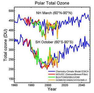
Total ozone
To understand these complex processes better, scientists rely on a long time series of data derived from observations and on results from numerical simulations based on complex atmospheric models.
Although ozone has been observed over several decades with multiple instruments, combining the existing observations from many different sensors to produce consistent and homogeneous data suitable for scientific analysis is a difficult task.
Within the ESA Climate Change Initiative, harmonised ozone climate data records are generated to document the variability of ozone changes better at different scales in space and time.
With this information, scientists can better estimate the timing of the ozone layer recovery, and in particular the closure of the ozone hole.
Chemistry climate models show that the ozone layer may be building up, and the hole over Antarctica will close in the next decades.
ESA
Guillermo Gonzalo Sánchez Achutegui
ayabaca@gmail.com
ayabaca@hotmail.com
ayabaca@yahoo.com

Turismo: La sorprendente ciudad subterránea de Derinkuyu


http://upload.wikimedia.org/wikipedia/commons/a/aa/Derinkuyu_Underground_City.JPG
Full resolution(3,456 × 2,592 pixels, file size: 3.13 MB, MIME type: image/jpeg)
 A typical view from inside the underground city in Derinkuyu, one of the largest underground complexes in Cappadocia. There are few artifacts left from the original builders, mainly just large rocks that was used to block the passage for intruders. Most of the "cities" are corridors, but some places there are rooms large enough to live in, and some rooms that have the cross-like shape of a church, which is probably exactly what they were.
Derinkuyu is a town and district of Nevşehir Province in the Central Anatolia region of Turkey. According to 2010 census, population of the district is 22,114 of which 10,679 live in the town of Derinkuyu.[1][2] The district covers an area of 445 km2 (172 sq mi),[3] and the average elevation is 1,300 m (4,265 ft), with the highest point being Mt. Ertaş at 1,988 m (6,522 ft).
Located in Cappadocia, Derinkuyu is notable for its large multi-level underground city (Derinkuyu Underground City), which is a major tourist attraction. The historical region of Cappadocia, where Derinkuyu is situated, contains several historical underground cities, carved out of a unique geological formation. They are not generally occupied. Over 200 underground cities at least two levels deep have been discovered in the area between Kayseri and Nevşehir, with around 40 of those having at least three levels. The troglodyte cities at Derinkuyu and Kaymaklı are two of the best examples of underground dwellings.
Wikipedia.

La sorprendente ciudad subterránea de Derinkuyu.........

 http://l3.yimg.com/bt/api/res/1.2/_MoB_0CWBfTEUlFM9WF_KA--/YXBwaWQ9eW5ld3M7cT04NQ--/http://media.zenfs.com/es-CO/blogs/desde-la-redaccion/Ilustracion-de-como-estaba-disenada-la-ciudad-subterranea-de-Derinkuyu-taringa.net_.jpgIlustración de cómo estaba diseñada la ciudad subterránea de Derinkuyu (taringa.net)

Por Alfred Lopez | La región de la Capadocia (Turquía) es famosa no solo por su importante pasado histórico, sino también por su característico paisaje geológico (declarado Patrimonio de la Humanidad por la UNESCO) , en el que nos podemos encontrar infinidad de viviendas que fueron construidas en el interior de sus montañas y más de 200 ciudades subterráneas, aunque tan solo hay una treintena de ellas accesibles.

Entre todas ellas destaca la que se encuentra bajo la ciudad de Derinkuyu, en la Anatolia central, una sorprendente y perfecta red de túneles y estancias con una capacidad para albergar a más de 10.000 personas (algunas fuentes apuntan que hasta 20.000) y cuya construcción tiene una antigüedad aproximada de 3.500 años.
Interior de la ciudad subterránea de Derinkuyu (Leyaya -Flickr / Creative Commons)Todo parece indicar que fue construida por el pueblo hitita, quienes por esa época estuvieron asentados en la zona, y como medio de defensa ante cualquier imprevisto ataque enemigo.
La ciudad subterránea de Derinkuyu tiene una veintena de niveles de profundidad, y aunque no se ha alcanzado el tope y solo se ha llegado hasta los 40 metros subterráneos (8 niveles), se calcula que la parte no accesible puede alcanzar los 85 metros.
El descubrimiento casual de este lugar ocurrió en 1963, cuando el propietario de una casa-cueva (muy típica en la zona) tiró una pared y se encontró que su vivienda comunicaba con otra estancia, de la que salía un túnel.
Tras ser inspeccionado por expertos, se comprobó que se trataba de una milenaria construcción, la cual estaba perfectamente diseñada para vivir largas temporadas sin tener que salir al exterior para nada, gracias a sus espacios adecuados para hacer la función de almacén de alimentos, el lugar donde tener los animales y, además, tenerlo todo perfectamente ventilado, gracias a los precisos conductos de ventilación que habían construido.
Puerta circular de piedra que bloqueaba uno de los pasillos de la ciudad subterránea de Derinkuyu (Basil & Tracy …También disponía de agua potable gracias a un rio subterráneo y a numerosos pozos que se realizaron. En caso de ser atacados el lugar quedaba herméticamente cerrado por unas puertas circulares de piedra cuyo peso aproximado era de media tonelada.
Resulta curioso observar que este pueblo, contando con los elementos más rudimentarios para construir ese lugar, no se olvidase de los espacios dedicados al ocio (como bares) o salas de culto en las que podían encomendarse a sus divinidades (la hitita era conocida como “la religión de los mil dioses”).
Cabe destacar que la estructura de la ciudad subterránea de Derinkuyu estaba estratégicamente diseñada para poder esconderse y huir en caso de que penetrase algún intruso, ya que disponía de escondrijos y recovecos imposibles de encontrar si no se conocía bien el lugar.
Estancia que se utilizaba como bar en la ciudad subterránea de Derinkuyu (Wikimedia commons)El único punto débil a toda esta ciudad eran sus pozos, a través de los cuales cualquier enemigo podría haber introducido veneno que iría a parar a las aguas subterráneas que después debían consumir sus habitantes. Algo que no han terminado de descartar los investigadores y expertos de que así ocurriera y fuese uno de los modos con los que los Pueblos del Mar atacasen y acabasen con los hititas.
Desde 1969 ocho niveles de esta sorprendente ciudad subterránea de Derinkuyu están abiertos a los visitantes, habiéndose convertido en uno de los puntos turísticos de mayor afluencia de la región de la Capadocia.

References:
1). http://www.cappadociaonline.com/
2). http://en.wikipedia.org/wiki/Derinkuyu
3). Tracy T. Twyman, Richard Metzger. The Arcadian Mystique. 2005.  Dragon Key Press.

 Guillermo Gonzalo Sánchez Achutegui 

ayabaca@gmail.com

ayabaca@hotmail.com

ayabaca@yahoo.com 

lunes, 4 de febrero de 2013

NASA - NASA's Super-Tiger Balloon Breaks Records While Collecting Data

NASA's Three Long Duration Balloon Missions Working Over Antarctica
2013-01-08


For the second time, the NASA Scientific Balloon Program managed at NASA’s Wallops Flight Facility, Wallops Island, VA, has three separate Long Duration Balloon (LDB) science missions afloat collecting data simultaneously. The previous time was during the 2007-2008 Antarctic campaign.

McMurdo Station, Antarctica The three missions in the current Antarctic summer Campaign, SuperTIGER, BLAST, and EBEX, were launched by NASA’s Columbia Scientific Balloon Facility (CSBF) in December 2012 from the LDB site near McMurdo Station, Antarctica.

The LDB site was established at Willy Field, McMurdo Station, in order to take advantage of the stratospheric anticyclone wind pattern circulating from east to west around the South Pole. The stratospheric wind circulation combined with the sparsely populated continent of Antarctica allows for long duration balloon flights at altitudes above 100,000 feet.

Super-TIGER was launched at 3:45 pm EST Dec 8, 2012. Super-TIGER, or Super Trans-Iron Galactic Element Recorder, is flying a new instrument for measuring the rare heavy elements among the flux of high-energy cosmic rays bombarding the Earth from elsewhere in our Milky Way Galaxay. The information retrieved from this mission will be used to develop an understanding where these energetic atomic nuclei are produced and how they achieve their very high energies.

The principal investigator of the SuperTIGER mission is Dr. Walter Binns of Washington University, St. Louis, Mo. The 39-million cubic foot scientific balloon is carrying SuperTIGER at a float altitude of 127,000 feet.

The second mission to launch in the campaign was BLAST, or the Balloon Borne Large Aperture Submillimeter Telescope, launched Dec. 25 at 1:57 p.m. EST. Galactic magnetic fields can polarize submillimeter-emitting micron-sized dust particles in star forming regions. The resulting emission is slightly polarized. By measuring the level of polarization, BLAST can help determine if magnetic fields are a dominant force over turbulence in regulating star formation in our Galaxy.

BLAST’s principal investigator is Dr. Mark Devlin of the University of Pennsylvania in Philadelphia. The 39-million cubic foot scientific balloon is at a float altitude of 126,000 feet.

The third and final mission of the Antarctic campaign was the heaviest payload ever launched aboard a NASA scientific balloon. Weighing in at 8,000 pounds, the EBEX experiment launched Dec. 29 at 7:27 p.m. EST. EBEX, or E&B Experiment, measures cosmic microwave background radiation, particularly its polarization. The cosmic microwave background is a type of radiation that fills the entire observable universe and is a relic remnant from the beginning of the universe. The discovery of the cosmic microwave background in the 1960's is a landmark confirmation of the big-bang model. EBEX is searching for signals from an inflationary expansion of the universe, which is thought to have taken place a fraction of a second after the big bang. Aside from being the heaviest payload ever launched aboard a NASA scientific balloon, EBEX is physically the largest payload ever to be flown by any balloon program worldwide. The 34 million cubic foot scientific balloon is carrying EBEX at a float altitude of 118,000 feet.

The principal investigator of the EBEX mission is Dr. Shaul Hanany of the University of Minnesota, Minneapolis, MN.

All three missions are still afloat over the Antarctic continent. They are monitored from the Operations Control Center at NASA’s CSBF in Palestine, Texas. BLAST and EBEX will stay afloat for another week; the flights will then be terminated at a location near McMurdo Station. SuperTIGER may stay afloat for several more weeks.

“I’m very proud of the NASA, CSBF, science, NSF/OPP and USAP personnel who have made this tremendous achievement possible” said Debora Fairbrother, chief of the NASA Balloon Program Office.

The National Science Foundation Office of Polar Programs manages the U.S. Antarctic Program and provides logistic support for all U.S. scientific operations in Antarctica. The NSF Antarctic Support Contractor (ASC) provides material support to the NASA Balloon Program, including support of launch and recovery operations throughout the Antarctic Campaign.

In addition, the Balloon Array for RPSP (Radiation Belt Storm Probes) Relativistic Electron Losses (BARREL) campaign is being conducted separately and independently of the NASA Balloon Program’s LDB Antarctic Campaign. The BARREL missions are hand launched balloons conducted by the science team from the remote sites of SANAE IV and Halley Research Station.

To follow the BARREL campaign activities, 
visit: http://relativisticballoons.blogspot.com/

To monitor the real time flight tracks of the balloons on the Internet, 
visit: http://www.csbf.nasa.gov/antarctica/ice.htm

For more information about NASA's balloon program on the Internet, 
 

Feature Articles


NASA's Three Long Duration Balloon Missions Working Over Antarctica - Jan 08, 2013
For the second time, the NASA Scientific Balloon Program managed at NASA’s Wallops Flight Facility, Wallops Island, VA, has three separate Long Duration Balloon (LDB)… Read More


Christmas Day BLAST! - Dec 26, 2012
NASA launched the Balloon-borne Large-Aperture Submillimeter Telescope or BLAST payload Dec. 25 from McMurdo Station, Antarctica, using a long duration balloon or LDB… Read More


Antarctic Balloon Campaign Underway - Dec 10, 2012
NASA's Balloon Program Office based at Wallops Flight Facility kicked off the winter Antarctic balloon campaign this weekend in McMurdo Station, Antarctica. On Saturday, December 8, the SuperTIGER payload was launched… Read More


NASA's Balloon Program Prepares for Antarctic Campaign! - Nov 27, 2012
NASA's Balloon Program Office based at Wallops Flight Facility is preparing for the annual winter Antarctic Campaign in McMurdo Station, Antarctica. This year's campaign features three missions: Super-TIGER, EBEX, and… Read More


2011-2012 Antarctica Campaign - Feb 8, 2012
After a late start the Antarctica campaign closed out with the successful flights of CREST and STO. Cosmic Ray Electron Synchrotron Telescope (CREST) - Dr. James Musser, Indiana University, was launched on December 25, and was… Read More

Code 820


Quick Links

NASA's Super-Tiger Balloon Breaks Records While Collecting Data
 
 
WASHINGTON -- A large NASA science balloon has broken two flight duration records while flying over Antarctica carrying an instrument that detected 50 million cosmic rays.

The Super Trans-Iron Galactic Element Recorder (Super-TIGER) balloon launched at 3:45 p.m. EST, Dec. 8 from the Long Duration Balloon site near McMurdo Station. It spent 55 days, 1 hour, and 34 minutes aloft at 127,000 feet, more than four times the altitude of most commercial airliners, and was brought down to end the mission on Friday. Washington University of St. Louis managed the mission.

On Jan. 24, the Super-TIGER team broke the record for longest flight by a balloon of its size, flying for 46 days. The team broke another record Friday after landing by becoming the longest flight of any heavy-lift scientific balloon, including NASA's Long Duration Balloons. The previous record was set in 2009 by NASA's Super Pressure Balloon test flight at 54 days, 1 hour, and 29 minutes.

"Scientific balloons give scientists the ability to gather critical science data for a long duration at a very low relative cost," said Vernon Jones, NASA's Balloon Program Scientist.

Super-TIGER flew a new instrument for measuring rare elements heavier than iron among the flux of high-energy cosmic rays bombarding Earth from elsewhere in our Milky Way galaxy. The information retrieved from this mission will be used to understand where these energetic atomic nuclei are produced and how they achieve their very high energies.

The balloon gathered so much data it will take scientists about two years to analyze it fully.

"This has been a very successful flight because of the long duration, which allowed us to detect large numbers of cosmic rays," said Dr. Bob Binns, principal investigator of the Super-TIGER mission. "The instrument functioned very well."

The balloon was able to stay aloft as long as it did because of prevailing wind patterns at the South Pole. The launch site takes advantage of anticyclonic, or counter-clockwise, winds circulating from east to west in the stratosphere there. This circulation and the sparse population work together to enable long-duration balloon flights at altitudes above 100,000 feet.

The National Science Foundation (NSF) Office of Polar Programs manages the U.S. Antarctic Program and provides logistic support for all U.S. scientific operations in Antarctica. NSF's Antarctic support contractor supports the launch and recovery operations for NASA's Balloon Program in Antarctica. Mission data were downloaded using NASA's Tracking and Data Relay Satellite System.

For more information about NASA's Balloon Program, visit:
NASA
Guillermo Gonzalo Sánchez Achutegui
ayabaca@gmail.com
ayabaca@hotmail.com
ayabaca@yahoo.com 

domingo, 3 de febrero de 2013

ESA - ESEO (European Student Earth Orbiter)

NUEVO SATÉLITE EDUCATIVO DE ESA DA UN GRAN PASO.-


El satélite ESEO
31 enero 2013 La nueva misión espacial diseñada por estudiantes universitarios de toda Europa entra en la fase avanzada de desarrollo, que será supervisada por la empresa italiana ALMASpace.
ESEO (European Student Earth Orbiter) es un microsatélite educativo que operará desde una órbita de baja altitud. El nuevo contratista principal, ALMASpace, supervisará las fases de desarrollo final, integración, ensayos y puesta en servicio.
El principal objetivo de esta misión es ofrecer a los estudiantes experiencia práctica en un proyecto espacial real, lo que les dotará con las cualidades necesarias para acceder con confianza a un puesto de trabajo altamente cualificado.
‘A través de ESEO, la Oficina de Educación y Gestión del Conocimiento de la ESA continúa con su misión de ofrecer actividades prácticas a los estudiantes universitarios de Europa. La oportunidad de participar en un proyecto real supone una fuerte fuente de motivación y una excelente preparación profesional para los futuros ingenieros y científicos europeos’, explica Piero Galeone, Responsable de la Unidad de Educación Terciaria de la ESA.
 
Configuración de las cargas útiles a bordo de ESEO
Durante la fase de diseño preliminar, también conocida como Fase B, el proyecto ESEO involucró a más de 200 estudiantes de 13 universidades de toda Europa. Al concluir esta fase, se decidió reducir el tamaño del satélite y se publicó un nuevo anuncio de licitación para seleccionar a una empresa europea que supervisase el desarrollo y los ensayos de ESEO.
Actualmente, nueve universidades europeas están trabajando con ALMASpace en la misión. Esta compañía italiana surgió de los Laboratorios de Microsatélites y Microsistemas Espaciales y Radiotelecomunicaciones de la Universidad de Bolonia en el año 2007, con el objetivo de poner en el mercado los resultados de su actividad investigadora en el campo de la ingeniería de sistemas espaciales.
‘Estamos orgullosos de haber sido seleccionados como el contratista principal para la continuación del proyecto ESEO’, comenta Paolo Tortora, Responsable del Programa ESEO en ALMASpace; ‘ALMASpace reconoce el alto valor educativo de este tipo de proyectos prácticos, más aún siendo una empresa formada por antiguos alumnos de la Universidad de Bolonia’.
Además de los aspectos ingenieriles inherentes a todo proyecto espacial, el componente educativo ocupará un papel central en el desarrollo de ESEO. Bajo la supervisión de la ESA, ALMASpace ofrecerá a los estudiantes la oportunidad de realizar prácticas complementarias a sus estudios universitarios, que incluirán clases impartidas por especialistas de renombre internacional y talleres de formación.
Los objetivos de esta misión son caracterizar el entorno de radiación ionizante en órbita, probar tecnologías para futuras misiones educativas y tomar fotografías de la Tierra o de otros cuerpos celestes con fines promocionales.
El instituto danés DTU Space desarrollará la microcámara del satélite, y la Universidad de Budapest, Hungría, el instrumento que monitorizará los niveles de radiación en órbita, un dato fundamental para vivir y trabajar en el espacio, ya que pueden provocar efectos adversos en equipos electrónicos y ser nocivos para la salud de los astronautas.
 
Representación de ESEO en órbita
Cada universidad es responsable de un aspecto diferente de la misión, entre los que se incluye el sistema de comunicaciones necesario para mantener el contacto con el satélite.
ESEO incorporará un dispositivo para acortar su vida en órbita, desarrollado por la Universidad de Cranfield, en el Reino Unido. Dicho dispositivo consiste en una vela que, una vez desplegada, aumenta la resistencia aerodinámica del satélite mientras surca las capas más altas de la atmósfera terrestre, lo que acelerará su descenso hasta poner fin a su misión, destruyéndose durante la reentrada.
ESEO es la tercera misión del Programa de Satélites Educativos de la ESA. Está basada en la experiencia adquirida con SSETI Express, lanzado en 2005, y con la cápsula experimental de reentrada YES2, puesta en órbita en 2007.
El satélite tendrá una masa de unos 40 kg y medirá 33x33x63 centímetros. Se lanzará en 2015-16 y llevará a cabo su misión durante un mínimo de seis meses.
 
Artist’s impression of ESEO deployed in orbit
Las nueve universidades involucradas en ESEO, y su contribución a la misión, son:
  • Universidad de Vigo (España) – GENSO para ESEO;
  • Universidad de Zaragoza (España) – Análisis de Misión
  • DTU Space (Dinamarca) – Microcámara;
  • Universidad de Budapest (Hungría) – Telescopio Dosimétrico y Sonda para la Diagnosis del Plasma;
  • Universidad de Breslavia (Polonia) – Subsistema de Comunicaciones en Banda-S;
  • Universidad de Bolonia (Italia) – Receptor GPS y Determinación de Órbita;
  • TU Delft (Países Bajos) – Sistema de Control de Actitud y Órbita;
  • Universidad de Cranfield (Reino Unido) – Dispositivo Desorbitador;
  • TU Múnich (Alemania) – Estación de Seguimiento en Banda-S;
Para más información:
Piero Galeone
Head of the Tertiary Education Unit
Piero.Galeone @ esa.int 


 ESEO workshop begins reshaping at start of phase B2
Students attending an ESEO workshop
22 December 2008 The first workshop to be conducted during the B2 development phase of the European Student Earth Orbiter (ESEO) was held from 15 to 19 December 2008. Organised by the ESA Education Office, the workshop took place in the Concurrent Design Facility (CDF) at the European Space Research and Technology Centre (ESTEC) in the Netherlands.
In the early stages of Phase B2, the ESEO project is studying the implementation of some important changes in requirements, in order to comply better with launch opportunities to fly the satellite to low Earth orbit as a secondary payload on one of the VEGA qualification flights.
This essentially involves a redesign to reduce the dry mass of the satellite and its payload from about 120 kg (as per Phase B1) to a target of 75 kg, while at the same time maintaining an architecture that will support the key systems and functions of the satellite.
The ESEO reconfiguration activity is led by Carlo Gavazzi Space, the Industrial Contractor for ESEO Phase B2 and Phase C/D, supported by their university coordination team.
ESEO preliminary design
The workshop involved the direct participation of 11 students from 7 different universities, who attended the ESTEC CDF in person, while five other students (representing subsystems to be designed by three additional universities) were involved via teleconference.
The workshop was also supported by AMSAT, an international group of amateur radio operators that is participating in ESEO by providing some of the satellite communication functions. AMSAT will enable the ESEO flight operations to access the Global Educational Network for Satellite Operations (GENSO) and the worldwide amateur radio network.
The end results of the workshop were the successful completion of the preliminary definition of the new ESEO configuration and the definition of the corresponding preliminary system budgets (mass, power, data links), as well as the identification of potentially critical areas that will require further attention at a later date.
ESEO project
ESEO is the second micro-satellite mission within the ESA Education Office’s Satellite Programme. It builds upon the experience gained with the SSETI Express micro-satellite, launched in 2005, and the YES2 student experiment flown in September 2007.
The project schedule foresees Phase B2 lasting one year, then a 2 year-long Phase C/D, followed by the launch campaign, with launch expected to take place in 2012.

ESA
Guillermo Gonzalo Sánchez Achutegui
ayabaca@gmail.com
ayabaca@hotmail.com
ayabaca@yahoo.com

NASA - Galaxy 2MASX J09442693+0429569


Hubble watches the lights go outGalaxy 2MASX J09442693+0429569
Hubble watches the lights go out Galaxy 2MASX J09442693+0429569 imaged by Hubble. This elliptical galaxy has entered a transitional phase from a young, star-forming galaxy to an older, larger, "red and dead" galaxy. Here, two galaxies have collided, exhausting the gases in the surrounding area and stopping the process of star birth. By contrast, as Hubble looks deeper into the Universe, galaxies show much more vigorous star birth. A merger is also predicted to happen between our own Milky Way Galaxy and neighbouring Andromeda in about four billion years.
Credits: ESA/Hubble & NASA, Acknowledgement: A. Zabludoff, N. Rose
ESA
Guillermo Gonzalo Sánchez Achutegui
ayabaca@gmail.com
ayabaca@hotmail.com
ayabaca@yahoo.com

ESA - Building a lunar base with 3D printing


  • Description Setting up a future lunar base could be made much simpler by using a 3D printer to build it from local materials. Industrial partners including renowned architects Foster+Partners have joined with ESA to test the feasibility of 3D printing using lunar soil.
    The base is first unfolded from a tubular module that can be easily transported by space rocket. An inflatable dome then extends from one end of this cylinder to provide a support structure for construction. Layers of regolith are then built up over the dome by a robot-operated 3D printer (right) to create a protective shell.
Lunar base made with 3D printing
31 January 2013 Setting up a lunar base could be made much simpler by using a 3D printer to build it from local materials. Industrial partners including renowned architects Foster + Partners have joined with ESA to test the feasibility of 3D printing using lunar soil.
“Terrestrial 3D printing technology has produced entire structures,” said Laurent Pambaguian, heading the project for ESA.
“Our industrial team investigated if it could similarly be employed to build a lunar habitat.”
Foster + Partners devised a weight-bearing ‘catenary’ dome design with a cellular structured wall to shield against micrometeoroids and space radiation, incorporating a pressurised inflatable to shelter astronauts.
A hollow closed-cell structure – reminiscent of bird bones – provides a good combination of strength and weight.
1.5 tonne building block
The base’s design was guided in turn by the properties of 3D-printed lunar soil, with a 1.5 tonne building block produced as a demonstration.
“3D printing offers a potential means of facilitating lunar settlement with reduced logistics from Earth,” added Scott Hovland of ESA’s human spaceflight team.
“The new possibilities this work opens up can then be considered by international space agencies as part of the current development of a common exploration strategy.”
Multi-dome base being constructed
“As a practice, we are used to designing for extreme climates on Earth and exploiting the environmental benefits of using local, sustainable materials,” remarked Xavier De Kestelier of Foster + Partners Specialist Modelling Group. “Our lunar habitation follows a similar logic.”
The UK’s Monolite supplied the D-Shape printer, with a mobile printing array of nozzles on a 6 m frame to spray a binding solution onto a sand-like building material.
D-Shape printer
3D ‘printouts’ are built up layer by layer – the company more typically uses its printer to create sculptures and is working on artificial coral reefs to help preserve beaches from energetic sea waves.
“First, we needed to mix the simulated lunar material with magnesium oxide. This turns it into ‘paper’ we can print with,” explained Monolite founder Enrico Dini. 
“Then for our structural ‘ink’ we apply a binding salt which converts material to a stone-like solid.
“Our current printer builds at a rate of around 2 m per hour, while our next-generation design should attain 3.5 m per hour, completing an entire building in a week.”
ESA
Guillermo Gonzalo Sánchez Achutegui
ayabaca@gmail.com
ayabaca@hotmail.com
ayabaca@yahoo.com

ESA: Las Estrellas pueden tener una maternidad tardía


Weighing the planet-forming disc around a nearby star


  • Description The 10 million-year-old star TW Hydrae is surrounded by a dense disc of planet-forming materials. Using ESA’s Herschel space observatory, astronomers have been able to ‘weigh’ the star’s disc with ten times higher accuracy than ever before, finding it still has enough mass to spawn 50 Jupiter-mass planets, several million years after most other stars have already given birth.
Utilizando las capacidades únicas del observatorio espacial Herschel de la ESA, los astrónomos han podido “pesar” con precisión el disco de una estrella, descubriendo que aún tiene la suficiente masa como para engendrar 50 planetas tipo Júpiter, y ello millones de años después de que muchas otras estrellas ya hayan “dado a luz”.  
Los discos protoplanetarios contienen todos los ingredientes brutos para fabricar planetas. Estos están compuestos, principalmente, por gas de hidrógeno molecular, que es muy transparente y, en esencia, invisible.
Normalmente, para hacer estimaciones sobre la masa total del disco, es mucho más fácil medir la emisión de “contaminantes”, como la pequeña fracción de polvo que se mezcla con el gas, o la de otros componentes del gas.
En el pasado, esta técnica ha causado significantes incertidumbres en las estimaciones de la masa del hidrógeno molecular, pero gracias a la información que proporciona la longitud de onda del infrarrojo lejano y a la sensibilidad de Herschel, los astrónomos han utilizado un método nuevo, más preciso, utilizando un pariente cercano del hidrógeno molecular llamado deuterio o hidrógeno “pesado”.
Dado que la proporción de gas de hidrógeno molecular “normal” y “pesado” es muy conocida por las medidas realizadas en nuestra vecindad local solar, esta aproximación proporciona un medio para “pesar” la masa total del disco de una estrella con una precisión diez veces mayor que la alcanzada con todas las técnicas utilizadas hasta el momento.
Utilizando esta técnica, se detectó una masa considerable de gas en el disco que rodea a TW Hydrae, una estrella joven que se encuentra a tan solo 176 años luz, en la constelación de la Hidra.
“No esperábamos encontrar tanto gas alrededor de esta estrella de 10 millones de años”, afirma el Profesor Edwin Bergin de la Universidad de Michigan, autor principal del artículo publicado enNature.
“Esta estrella tiene mucha más masa de la necesaria para generar un sistema solar como el nuestro y podría crear un sistema mucho más exótico con planetas más masivos que Júpiter”.
Observar un disco tan masivo en torno a TW Hydrae no es lo normal para estrellas de esta edad ya que, normalmente, en unos pocos millones de años, o bien el material se incorpora a la estrella central o a planetas gigantes, o bien es expulsado por los fuertes vientos estelares.
“Con datos más precisos sobre la masa, podemos aprender más sobre este sistema en términos de su potencial para crear planetas y la disponibilidad de ingredientes que pueden facilitar que haya vida en un planeta”, añade el Profesor Bergin. 
De hecho en otro sondeo de Herschel, científicos ya habían descubierto que TW Hydrae  era una estrella con un disco que contenía agua suficiente como para llenar varios miles de océanos como los de la Tierra.
El nuevo método para “pesar” un disco da a entender que el volumen de material disponible – incluida el agua – ha podido ser infravalorado, tanto en este como en los otros sistemas.
Una reevaluación de la masa de los discos en torno a otras estrellas de distintas edades proporcionará un mejor entendimiento del proceso que origina los planetas. 
“Puede haber diferentes resultados en relación a la formación de planetas para sistemas de diferentes edades”, afirma el Profesor Thomas Henning, coautor de este trabajo e investigador del Instituto Max Planck de Astronomía, en Alemania.  
“Al igual que la edad en la que las personas tienen hijos se enmarca en un rango, TW Hydrae parece estar al límite de ese rango para las estrellas, demostrando que este sistema en particular puede haber necesitado más tiempo para formar planetas, con lo cual sería una maternidad tardía”.
“La detección de hidrógeno molecular pesado fue posible gracias a las nuevas capacidades de observación ofrecidas por Herschel, que proporciona este salto hacia adelante a la hora de calcular el peso del disco que rodea a esta estrella”, añade Göran Pilbratt, científico responsable del proyecto Herschel en la ESA. 

Más información:
El artículo “Un disco viejo que aún puede formar un sistema planetario (An old disk that can still form a planetary system)” por E. Bergin et al, se ha publicado en la revistaNatureel 31 de enero de 2013.
El sondeo fue llevado a cabo como parte de un programa de tiempo abierto de Herschel utilizando el instrumento PACS (Photoconductor Array Camera and Spectrometer), que opera en longitudes de onda de entre 55 y 210 micras.
Herschel es un observatorio espacial de la ESA equipado con instrumentos desarrollados por consorcios liderados por investigadores europeos, con una importante participación de la NASA. El instrumento PACS fue diseñado y construido por un consorcio financiado por los países participantes y liderado por el Instituto Max Planck Institute de Física Extraterrestre (Garching, Alemania); el consorcio incluye a centros  de Bélgica, Austria, Francia, Italia y España. 
ESA
Guillermo Gonzalo Sánchez Achutegui
ayabaca@gmail.com
ayabaca@hotmail.com
ayabaca@yahoo.com