miércoles, 30 de enero de 2013

NASA - Water Bubble in Space


NASA astronaut Kevin Ford, Expedition 34 commander, watches a water bubble float freely between him and the camera, showing his image refracted, in the Unity node of the International Space Station. Image Credit: NASA

Download Image


NASA
Guillermo Gonzalo Sánchez Achutegui
ayabaca@gmail.com
ayabaca@hotmail.com
ayabaca@yahoo.com

martes, 29 de enero de 2013

ESA - When a planet behaves like a comet


 Artist’s impression of an active volcano on Venus. Results from a long-term study of Venus find evidence of a clear injection of sulphur dioxide into its upper atmosphere. One possible interpretation is that volcanic activity increased the sulphur dioxide component of the upper atmosphere, although an alternative is that a change in atmospheric circulation dredged up the gas.
Six years of observations by ESA’s Venus Express have shown large changes in the sulphur dioxide content of the planet’s atmosphere, and one intriguing possible explanation is volcanic eruptions.
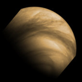
The thick atmosphere of Venus contains over a million times as much sulphur dioxide as Earth’s, where almost all of the pungent, toxic gas is generated by volcanic activity.
Most of the sulphur dioxide on Venus is hidden below the planet’s dense upper cloud deck, because the gas is readily destroyed by sunlight.
That means any sulphur dioxide detected in Venus’ upper atmosphere above the cloud deck must have been recently supplied from below.
Venus is covered in hundreds of volcanoes, but whether they remain active today is much debated, providing an important scientific goal for Venus Express.
The mission has already found clues pointing to volcanism on geologically recent timescales, within the last few hundreds of thousands to millions of years.
A previous analysis of infrared radiation from the surface pointed to lava flows atop a volcano with a composition distinct from those of their surroundings, suggesting that the volcano had erupted in the planet’s recent past.
Now, an analysis of sulphur dioxide concentration in the upper atmosphere over six years provides another clue.  

Rise and fall of sulphur dioxide
Immediately after arriving at Venus in 2006, the spacecraft recorded a significant increase in the average density of sulphur dioxide in the upper atmosphere, followed by a sharp decrease to values roughly ten times lower by today.
A similar fall was also seen during NASA’s Pioneer Venus mission, which orbited the planet from 1978 to 1992.
At that time, the preferred explanation was an earlier injection of sulphur dioxide from one or more volcanoes, with Pioneer Venus arriving in time for the decline.
“If you see a sulphur dioxide increase in the upper atmosphere, you know that something has brought it up recently, because individual molecules are destroyed there by sunlight after just a couple of days,” says Dr Emmanuel Marcq of Laboratoire Atmosphères, Milieux, Observations Spatiales, France, and lead author of the paper published in Nature Geoscience.
“A volcanic eruption could act like a piston to blast sulphur dioxide up to these levels, but peculiarities in the circulation of the planet that we don’t yet fully understand could also mix the gas to reproduce the same result,” adds co-author Dr Jean-Loup Bertaux, Principal Investigator for the instrument on Venus Express that made the detections.
Venus has a ‘super-rotating’ atmosphere that whips around the planet in just four Earth-days, much faster than the 243 days the planet takes to complete one rotation about its axis.
Such rapid atmospheric circulation spreads the sulphur dioxide around, making it difficult to isolate any individual points of origin for the gas.
Dr Marcq’s team speculate that if volcanism was responsible for the initial increase, then it could come from a relatively gentle increased output of several active volcanoes rather than one dramatic eruption.
“Alternatively, and taking into account the similar trend observed by Pioneer Venus, it’s possible that we are seeing decadal-scale variability in the circulation of the atmosphere, which is turning out to be even more complex than we could ever have imagined,” he notes.
“By following clues left by trace gases in the atmosphere, we are uncovering the way Venus works, which could point us to the smoking gun of active volcanism,” adds Håkan Svedhem, ESA’s Project Scientist for Venus Express.
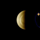
Comet-like ionosphere at Venus

The change in ionosphere of Venus during normal solar wind conditions (left) and reduced solar wind activity (right), as observed by ESA’s Venus Express spacecraft in August 2010.  The yellow lines show a projection of the solar magnetic field lines as they interact with the ionosphere.
Venus Express follows an elliptical orbit around the planet once every 24 hours, passing within 250 km of the north pole and 66 000 km over the south pole. The observations were made on the nightside of the planet, when Venus Express was within 15 000 km of the centre of the planet. Although the spacecraft only took measurements within two Venus radii, the findings suggest that the ionosphere likely extends to even greater distances during periods of reduced solar wind intensity.

When a planet behaves like a comet.
ESA’s Venus Express has made unique observations of Venus during a period of reduced solar wind pressure, discovering that the planet’s ionosphere balloons out like a comet’s tail on its nightside.  
The ionosphere is a region of weakly electrically charged gas high above the main body of a planet’s atmosphere. Its shape and density are partly controlled by the internal magnetic field of the planet.
For Earth, which has a strong magnetic field, the ionosphere is relatively stable under a range of solar wind conditions. By comparison, Venus does not have its own internal magnetic field and relies instead on interactions with the solar wind to shape its ionosphere.
The extent to which this shaping depends on the strength of the solar wind has been controversial, but new results from Venus Express reveal for the first time the effect of a very low solar wind pressure on the ionosphere of an unmagnetised planet.
The observations were made in August 2010 when NASA’s Stereo-B spacecraft measured a drop in solar wind density to 0.1 particles per cubic centimetre, around 50 times lower than normally observed; this persisted for about 18 hours. 
As this significantly reduced solar wind hit Venus, Venus Express saw the planet’s ionosphere balloon outwards on the planet’s ‘downwind’ nightside, much like the shape of the ion tail seen streaming from a comet under similar conditions.
“The teardrop-shaped ionosphere began forming within 30–60 minutes after the normal high pressure solar wind diminished. Over two Earth days, it had stretched to at least two Venus radii into space,” says Yong Wei of the Max Planck Institute for Solar System Research in Germany, lead author of the new findings.
The new observations settle a debate about how the strength of the solar wind affects the way in which ionospheric plasma is transported from the dayside to the nightside of Venus.
Usually, this material flows along a thin channel in the ionosphere, but scientists were unsure what happens under low solar wind conditions. Does the flow of plasma particles increase as the channel widens due to the reduced confining pressure, or does it decrease because less force is available to push plasma through the channel?
“We now finally know that the first effect outweighs the second, and that the ionosphere expands significantly during low solar wind density conditions,” says Markus Fraenz, also of the Max Planck Institute and co-author on the paper.
A similar effect is also expected to occur around Mars, the other non-magnetised planet in our inner Solar System.
“We often talk about the effects of solar wind interaction with planetary atmospheres during periods of intense solar activity, but Venus Express has shown us that even when there is a reduced solar wind, the Sun can still significantly influence the environment of our planetary neighbours,” adds Håkan Svedhem, ESA’s Venus Express project scientist.
ESA.
Venus cloud tops
Chasing clouds on Venus08 October 2012

Guillermo Gonzalo Sánchez Achutegui
ayabaca@gmail.com
ayabaca@hotmail.com
ayabaca@yahoo.com

ESA - La cara más fría de Andrómeda

Andromeda: our nearest large galactic neighbour


The Andromeda Galaxy is our nearest large galactic neighbour, containing several hundred billion stars. Combined, these images show all stages of the stellar life cycle. The infrared image from Herschel shows areas of cool dust that trace reservoirs of gas in which forming stars are embedded. The optical image shows adult stars. XMM-Newton’s X-ray image shows the violent endpoints of stellar evolution, in which individual stars explode or pairs of stars pull each other to pieces.
5 January 2011 Two ESA observatories have combined forces to show the Andromeda Galaxy in a new light. Herschel sees rings of star formation in this, the most detailed image of the Andromeda Galaxy ever taken at infrared wavelengths, and XMM-Newton shows dying stars shining X-rays into space.
During Christmas 2010, ESA’s Herschel and XMM-Newton space observatories targeted the nearest large spiral galaxy M31. This is a galaxy similar to our own Milky Way – both contain several hundred billion stars. This is the most detailed far-infrared image of the Andromeda Galaxy ever taken and shows clearly that more stars are on their way.
Andromeda Galaxy seen in infrared
Sensitive to far-infrared light, Herschel sees clouds of cool dust and gas where stars can form. Inside these clouds are many dusty cocoons containing forming stars, each star pulling itself together in a slow gravitational process that can last for hundreds of millions of years. Once a star reaches a high enough density, it will begin to shine at optical wavelengths. It will emerge from its birth cloud and become visible to ordinary telescopes.
Many galaxies are spiral in shape but Andromeda is interesting because it shows a large ring of dust about 75 000 light-years across encircling the centre of the galaxy. Some astronomers speculate that this dust ring may have been formed in a recent collision with another galaxy. This new Herschel image reveals yet more intricate details, with at least five concentric rings of star-forming dust visible.
La cara más fría de Andrómeda

ESA Herschel space observatory image of Andromeda (M31) using both PACS and SPIRE instruments to observe at infrared wavelengths of 70 mm (blue), 100 mm (green) and 160 mm and 250 mm combined (red). The image spans approximately 1 x 3 degrees.
This image was featured as space science image of the week on 28 January 2013.

La Cara más fría de Andrómeda.
Esta nueva imagen de la galaxia de Andrómeda, tomada por el observatorio espacial Herschel de la ESA, nos muestra las regiones de la galaxia en las que se están formando nuevas estrellas con un nivel de detalle sin precedentes.
La galaxia de Andrómeda, también conocida como M31, se encuentra a 2.5 millones de años luz de nuestro planeta, lo que la convierte en la galaxia principal más cercana a la Vía Láctea y en un objetivo ideal para estudiar la formación de las estrellas y la evolución de las galaxias.
Los instrumentos de Herschel, capaces de detectar la luz emitida por la fría mezcla de polvo y gas interestelar en la banda del infrarrojo lejano, estudia las nubes de las que surgirán nuevas estrellas. Esta imagen nos muestra algunas de las nubes más frías de la galaxia – a tan sólo unas décimas de grado por encima del cero absoluto – coloreadas en rojo.
El color azul marca las regiones relativamente más cálidas, como el bulbo galáctico, densamente poblado por estrellas más antiguas.
La galaxia de Andrómeda, con una extensión de 200.000 años luz, presenta una compleja estructura en la que las regiones de formación de estrellas están organizadas a lo largo de brazos en espiral y de al menos cinco anillos concéntricos, intercalados con bandas oscuras sin actividad.
Esta imagen revela que en la galaxia de Andrómeda, hogar de cientos de miles de millones de estrellas, pronto comenzarán a brillar muchas más.
ESA
Guillermo Gonzalo Sánchez Achutegui
ayabaca@gmail.com
ayabaca@hotmail.com
ayabaca@yahoo.com

domingo, 27 de enero de 2013

CAMBIO CLIMÁTICO: Las multinacionales del motor pueden salir favorecidas de la polución en China


Shanghái (China), 25 ene (EFEverde).- Las grandes multinacionales internacionales del motor presentes en China pueden llegar a ser, inesperadamente, los grandes beneficiarias de los serios problemas de polución del país, ya que los fabricantes chinos aún carecen de la tecnología menos contaminante.

Viajes y Cultura
National Geographic ChannelNATIONAL GEOGRAPHIC


Fotografía de Sung Ming Whang, My Shot
La red en continuo crecimiento de autopistas en Shanghái rodea la ciudad y enlaza más de 500 ciudades de 22 zonas provinciales.

Fotografía de Fritz Hoffmann
El piso 94 de la torre del World Financial Center de Shanghái presenta una vista inmaculada de la extensión urbana de la ciudad. Con una altura de 492 metros, el edificio es el rascacielos más alto de China y se enorgullece de poseer el muelle de observación más alto del mundo en el piso 100. La construcción del edificio comenzó en 1997, duró 14 años y costó más de 1000 millones de dólares.
Fotografía de Arkadiusz Dudzinski, My Shot
La lluvia no desanima a los compradores para navegar entre los cientos de puestos que se amontonan en la calle Tung Choi de Kowloon, Hong Kong. Conocido como el Mercado de las Damas, el bazar ofrece toda variedad de productos para señoras, desde cosméticos y ropa interior a artículos y productos para el hogar.
Fotografía de Grant Faint y Getty Images
Cerca de la elaborada Chenghuang, o Templo del Dios de la Ciudad, en Shanghái se encuentran los famosos Bazar y Jardines de Yu Yuan. Las casas de té se alinean en la calle principal, donde los turistas se amontonan cada mañana para comprar caligrafía, perlas y antigüedades.
Fotografía de Eko Wibowo Putra, My Shot
Incluida como sitio del Patrimonio Mundial, el conjunto monumental del palacio imperial de la Ciudad Prohibida (Pekín) fue el hogar de los emperadores gobernantes durante casi 500 años tras su finalización en 1420. Contiene 9.999 habitaciones, ya que el nueve es el número de la suerte en la superstición china.


Shanghai & Nanjing Esencias Tour

www.viaje-a-china.com - 800 × 602 - More sizes

Las grandes multinacionales internacionales del motor presentes en China pueden llegar a ser, inesperadamente, los grandes beneficiarias de los serios problemas de polución del país, ya que los fabricantes chinos aún carecen de la tecnología menos contaminante. En la foto de archivo, vista aérea del tráfico en una autopista en la ciudad de Shangai. EFE/Qilai Shen

Habitualmente los grandes fabricantes mundiales se reservan sus modelos y tecnología más avanzada para los mercados más desarrollados de Europa, Norteamérica y Japón, y producen modelos y motores algo anteriores en China, mediante empresas mixtas con fabricantes locales, para crecer con el mayor mercado del planeta.
Sin embargo, ante la posibilidad de que los crecientes problemas de contaminación aceleren los planes del Gobierno chino para endurecer los estándares de emisiones para los vehículos en sus carreteras, las firmas extranjeras tienen una posibilidad de aumentar su cuota de mercado frente a sus competidoras chinas.
Aún tendrán que decidir hasta qué punto compartir tecnología puntera mediante sus empresas mixtas en el país, pero al menos los gigantes europeos, estadounidenses, japoneses y coreanos tienen la tecnología necesaria para cumplir con los estándares más exigentes.
transporte de trabajadores de una fábrica de cemento en Yangchang, China.
Foto/EFE/Str
Las marcas chinas
Las marcas chinas, en cambio, necesitarían tiempo para desarrollar vehículos menos contaminantes que aún no tienen, salvo en el caso de híbridos y eléctricos de firmas como la cantonesa BYD, que también produce autobuses eléctricos, igual que la pequinesa Beiqi, o la shanghainesa Roewe, con su turismo de baterías E50.

La propia BYD retiró recientemente de la prensa china una serie de anuncios publicitarios en los que aseguraba que las emisiones contaminantes caerían en China un 27 por ciento si sólo los taxis y los autobuses de todo el país fuesen sustituidos por las alternativas eléctricas de la compañía, recoge hoy la prensa local.
Por su parte, multinacionales europeas como Volkswagen, la primera firma extranjera en el país -desde 1984-, redujo un 20 por ciento desde 2005 las emisiones y el consumo de los modelos que produce en China (junto a la shanghainesa SAIC), y ha asegurado ya que está "bien preparada" para el China V.
Tras los máximos históricos de contaminación que ha registrado en las últimas semanas, la ciudad de Pekín se convirtió esta semana en la primera en anunciar que impondrá la venta y el tráfico de vehículos bajo el estándar local China V, muy similar en sus exigencias al Euro V europeo.
Más de 200.000 coches altamente contaminantes
La capital china, junto a otras grandes metrópolis del país, como Shanghái y Cantón, aplicaba hasta ahora sobre el papel el estándar China IV (equivalente al Euro IV), aunque en la práctica cientos de miles de vehículos lo incumplen seriamente a diario en las calles de estas ciudades.

Shanghái tenía ya planes para aplicar el estándar China V en 2014, lo que en teoría sacaría de sus carreteras más de 60.000 vehículos altamente contaminantes, y debería reducir la cantidad de dióxidos sulfurosos que liberan los vehículos en cerca de un 80 por ciento en comparación con los estándares actuales China IV.
Sin embargo, aunque oficialmente Shanghái, Pekín y Cantón imponen estas normas similares al Euro IV desde 2008, sólo en Shanghái, en la práctica, el 74 por ciento de la contaminación viene de los 280.000 vehículos (el 17 por ciento del total) que ni siquiera cumplen los China I para gasolina ni los China III para queroseno.
Tráfico y polución en Beijing (China).
FOTO/EFE/Adrian Bradshaw
De las cifras proporcionadas por la propia prensa oficial se deduce que los vehículos que no cumplirán la normativa china para 2014 en Shanghái, bajo el China V, rondarán todavía los 220.000, a pesar de que el 25 por ciento de las partículas PM 2,5 de la ciudad, las más peligrosas, proviene de motores de vehículos y barcos.
Contaminación urbana
En metrópolis como Shanghái muy a menudo una espesa neblina envuelve los más de 15.000 rascacielos de la ciudad, cuyos habitantes sufren con frecuencia tos seca, irritación de ojos, dificultades para respirar y fatiga, aunque están habituados a pasar períodos de fuerte contaminación.

La situación es similar en Pekín, Cantón, Chengdu, Chongqing y la mayoría de las capitales de provincia y ciudades medianas de gran parte del país asiático. EFEverde
EFE
Guillermo Gonzalo Sánchez Achutegui
ayabaca@gmail.com
ayabaca@hotamil.com
ayabaca@yahoo.com

CAMBIO CLIMÁTICO: La fiebre del petróleo alcanza los últimos santuarios del Norte

Tromso (Noruega), 23 ene (EFE).- Lofoten, Islandia, Groenlandia, y otros santuarios del Norte habían resistido hasta ahora la fiebre del 'oro negro', pero la mayor accesibilidad a estos territorios, paradójicamente debido al cambio climático, ha tornado en irresistible para los países la explotación de sus últimos paraísos inexplorados. 


Full resolution ‎(1,280 × 800 pixels, file size: 341 KB, MIME type: image/jpeg)
Reine, Lofoten, visto desde lo alto del monte Reinebringen (junio de 2003)
Wikipedia.


Islas lofoten noruega

 . Blog de Noruega.
www.elblogdenoruega.com - 795 × 377 - More sizes


Lofoten Trip | ESN Trondheim

www.trondheim.esn.no - 1000 × 794 - More sizes


Imagen de archivo de las Islas Lofoten (Noruega). EFE/Caty Arevalo


El ministro islandés de Industria, Steingrimur Sigfusson, anunció en el Congreso Internacional sobre el Artico que tiene lugar esta semana en la ciudad noruega de Tromso que Islandia abrirá las aguas del Nordeste del país (al sur de la isla noruega de Jan Mayen) a la exploraciones petroleras. 
Islandia, la "Arabia Saudí" de la energía geotérmica, no se había decidido hasta ahora a extraer sus posibles yacimientos de hidrocarburos. 
Sin embargo, la frágil economía de este país desde la gran crisis que sufrió en 2008 parece haber sido el detonante para que la isla, de apenas 320.000 habitantes, haya decidido dar este paso. 

OPINION PUBLICA DIVIDIDA
Preguntado por Efe sobre por qué en pleno movimiento de los países por buscar una alternativa a los combustibles fósiles Islandia decide apostar por ellos, Sigfusson contesta que "nos guste o no seguiremos dependiendo del petróleo durante varias décadas y ese petróleo tiene que venir de algún sitio". 
El ministro islandés reconoce que la opinión pública de su país está dividida en torno a la decisión del Gobierno de lanzarse por primera vez a la exploración de hidrocarburos, "aunque completamente de acuerdo en que, de haber recursos, tendrán que extraerse con los más estrictos controles ambientales". 
"¿Por qué tiene que decidir Islandia unilateralmente no extraer sus recursos naturales y mejorar su economía cuando el resto de países lo están haciendo, como Groenlandia, las Islas Feroe o Noruega junto al borde marítimo con Islandia, al sur de la isla de Jan Mayen?", se preguntó. 
El Gobierno islandés estima que la zona costera donde se harán las exploraciones puede contener entre 250 y 500 millones de barriles de petróleo y acaba de conceder dos licencias para constatarlo a dos consorcios, en los que está, con un 25% de participación, la empresa nacional noruega Petoro. 

MAS PROSPECCIONES EN GROENLANDIA
Otra de las regiones que ha visto en las consecuencias del cambio climático una "oportunidad" es Groenlandia, que perdió casi el cien por cien de su cubierta helada el pasado verano. 
Sara Olsvig, representante de Groenlandia en el Parlamento danés explicó a Efe que las autoridades de esta isla van a conceder licencias para llevar a prospecciones de petróleo en 2013 y 2014. 
Las exploraciones se harán en la costa nordeste del país, mucho más arriba de Islandia y vendrían a sumarse a las más de 20 licencias que hay ya concedidas. 
Olsving justifica que los 57.000 habitantes de esta isla "ven en el gas y en el petróleo una oportunidad para poder desarrollarse económicamente y consolidar su cada vez mayor independencia de Dinamarca". 

LOFOTEN, EL ULTIMO PARAISO INEXPLORADO DE NORUEGA
Las aguas vírgenes de las islas Lofoten y Vesteralen, hogar del caladero de bacalao más saludable de Noruega y consideradas por National Geographic como el tercer archipiélago más bello del planeta, tampoco escapan a la fiebre del petróleo. 
El ministro noruego de Energía, Ola Borten Moe, avanza también su intención de abrir este paraíso a la extracción, contradiciendo la postura del primer ministro de Noruega, Helge Lund, quien había mantenido que, al menos durante esta legislatura (que acaba en septiembre), las petroleras no entrarían en estas idílicas islas. 
Lund ha tenido que cancelar a última hora su participación en el Congreso Internacional sobre el Ártico en Tromso, a casi dos horas de vuelo de Oslo, por el ataque terrorista en Argelia. 
En su lugar ha asistido el ministro de Exteriores, Espen Barth, quien indica que el Consejo Ártico está negociando un acuerdo de cooperación en caso de vertidos ante las intenciones de los países árticos de perforar cada vez más al Norte.

UN ACUERDO DE COOPERACION EN CASO DE VERTIDO 
La resolución, que se aprobará previsiblemente en la reunión que los miembros del Consejo Ártico celebraran en mayo en Suecia, pretende delimitar responsabilidades en caso de derrames de barcos y plataformas petroleras, así como establecer un sistema de información y alerta temprana ante estas situaciones. 
Frente a esas posiciones, Maren Esmark, secretaria general de Amigos de la Tierra en Noruega, critica que los responsables políticos hayan acudido a un encuentro sobre el Ártico a "hablar exclusivamente de las oportunidades que, según ellos, ofrece el cambio climático". 
"En sus discursos solo hemos oído oportunidades, oportunidades y oportunidades. No mencionan la catástrofe que supondría un vertido en el Ártico y las emisiones que generarían los hidrocarburos que pretenden extraer para empeorar aún más el cambio climático", añadió. EFE 

Contenidos relacionados

Guillermo Gonzalo Sánchez Achutegui
ayabaca@gmail.com
ayabaca@hotmail.com
ayabaca@yahoo.com

BIODIVERSIDAD Y AGUA: Los colores del agua

Madrid, 26 ene (EFE).- Los colores del agua, verde, azul, gris, negro y hasta amarillo, por acuerdo de los organismos internacionales garantes de este recurso universal, son seña de origen del preciado líquido, cuyo ciclo solidario de vida se celebra este año 2013 y se inaugura la semana próxima en Madrid. 


ART EXHIBITIONS BARCELONA FAN


ART EXHIBITIONS BARCELONA FAN


ART EXHIBITIONS BARCELONA FAN


Los colores del agua | ISon21


Agua gris- Los problemas del agua

El Museo de la Ciencia de Valladolid expone ‘Los Colores del agua’ hasta el 3 de mayo. Esta muestra itinerante viajará después a Fuenlabrada, Tarragona y Logroño.
Este próximo lunes 16 arranca el V Foro Mundial del Agua donde España aportará su gota de agua; con su tecnología puntera en asuntos como la desalación, sus estrategias políticas y con su experiencia en temas como la sequía o las inundaciones.
Nuestro país está concienciado con los problemas del agua pero cualquier esfuerzo es poco para cuidar nuestro recurso más preciado. De ahí que el Museo de la Ciencia de Valladolid acoja la exposición ‘Los colores del agua’ para recordarnos los beneficios y las aportaciones del agua. 
La muestra da a conocer buena parte de las funciones, los problemas, los usos y los servicios que el agua presta a la población con el objetivo de sensibilizar sobre una preocupante cuestión ambiental que ya es problema de todos. 
Por todo esto, la muestra constituye un viaje por las asombrosas propiedades del agua, en sus enfermedades y en los caminos a seguir para que el agua siga regalando a la población la incesante renovación de la vida. 
‘Los colores del agua’  se puede visitar de martes a domingo de 10.00 a 19.00 horas.  Su estructura temática corresponde a los cuatro colores del agua, desarrollando cada uno de ellos una idea argumental distinta: 


El agua verde
  •  Agua azul, las geografías del agua. Este bloque hace un recorrido por la geografía del agua, haciendo especial hincapié en las diferencias de extensión entre las aguas de los océanos y las aguas dulces, así como en la diferente disponibilidad de este último tipo de líquido según zonas.
  • Agua verde, el agua de la vida.  Este apartado destaca la enorme importancia del líquido transparente en el desarrollo y supervivencia de los seres humanos, plantas y organismos vivos existentes. 
  • Agua gris, las enfermedades del agua. La falta de actitudes de respeto hacia el agua y el despilfarro de la misma ocasionan graves problemas con consecuencias nefastas. La exposición de algunos de ellos, tales como la desertificación o las catástrofes hídricas, constituyen una llamada de atención para la población.
  • Agua transparente, sostenibilidad. Trabajar para la recuperación de la transparencia del agua es lo mínimo que la humanidad puede hacer. Este punto muestra como este proceso, basado en el ahorro y la sostenibilidad, sí es posible.

Los colores del agua.

Esta muestra pretende dar a conocer buena parte de las funciones y servicios que el agua nos presta. Los investigadores han consolidado a través de diferentes colores, denominaciones básicas de este líquido como la de azul para el agua fluyente y la de verde para la que forma parte de los suelos, la vegetación y los seres vivos. En cualquier caso, hoy nos afecta, sobre todo, el color negro o gris que nuestra actividad contagia a las aguas.
La muestra viaja a través de esos colores del agua, pero sobre todo desemboca en un aspecto y concepto que es la transparencia, porque pretendemos que el incremento de nuestros conocimientos y la asunción de responsabilidades, con relación a las salud de nuestros cursos fluviales y acuíferos, se convierta en una garantía para el desarrollo futuro.
CAJA MADRID OBRA SOCIAL.


El color del Agua

¿De que color es el agua? Es una pregunta que muchos niños realizan y la respuesta que siempre reciben es "no tiene color" o "es transparente", pero ¿es del todo correcta esta afirmación?
El agua tiene color pero no es algo que el ojo humano pueda apreciar en pequeñas cantidades. Para darnos cuenta del color del agua debemos observarla en un lugar donde halla un gran volumen de agua. Puede hacerse de forma científica, pero el ojo humano en las condiciones correctas también puede ver el color intrínseco del agua.
El color del agua es azul, azul claro o turquesa dependiendo de diferentes factores. Algunos sostienen que el color del agua se debe al reflejo del cielo, en una superficie de grandes dimensiones como el mar. ¿Pero si el cielo se encuentra cubierto por nubes, porque vemos el mismo color un poco mas oscuro?. La verdad es que el reflejo de la luz contribuye con la apariencia del agua, pero solo cuando la superficie esta quieta.
La intensidad del color causado por el reflejo se debe (mayormente) al angulo en que se observe, que en términos científicos se denomina angulo de incidencia. En pocas palabras es el numero de grados de distancia que nos separan cuando miramos al objeto en angulo recto. A mayor ángulo, mas azul se verá el agua debido al reflejo. Esto se debe a que la reflexibilidad del agua es mayor cuando mayor es el angulo de incidencia.
Obviamente lo que el agua contenga jugará un papel determinante en el color que percibimos en ella. En la siguiente foto se muestra un estanques de sal (EEUU) llenos de algas rosadas. Y debido a la presencia (en cantidades enormes) de la microalga Dunaliella salina es que apreciamos este estanque color rosa. Entonces podemos asegurar que a menudo lo que el agua contenga determinara el color que vemos?
La luz del sol contiene todos los colores del espectro. El agua absorbe todos los colores pero algunos mas que otros. Esto se aprecia solamente en grandes volúmenes. La prueba de ello es tan simple como tomar una taza con agua de mar, la veremos transparente. Si arrojamos dicha agua nuevamente al mar se fundirá con el resto de incontables moléculas de H2O y se tornará (a nuestros ojos) de nuevo el color azul.
El agua no absorbe bien el color azul, esta luz es transmitida a través del agua y es por ello que la vemos de este color, porque no se absorbe. Este mismo principio se aplica al cielo.
A mas profundidad mas pronunciado es el azul. Este color puede ser observado también en la nieve y en los glaciares.
Fuentes 1   2   3

Trackback URL:

http://www.lareserva.com/home/trackback/1348


Fotografía de archivo en la que se observa una flor con varias gotas de agua en Quito (Ecuador). EFE


Comprender que el agua no está solo en los grifos ni que esa es su fuente primaria es el propósito de esta "coloración" simbólica que ayuda a los expertos a poner valor a un bien natural e universal, imprescindible en todos los procesos vitales y productivos, de la naturaleza y la sociedad.

Relación valor/coste

Para establecer la relación valor y coste de un recurso que tiene un precio irregular, investigadores de todo el mundo acordaron desde hace unos diez años poner "color" a un elemento popularmente conocido como insípido, incoloro e inodoro, explicó a EFEverde el catedrático Alberto Garrido, subdirector del Observatorio del Agua de la Fundación Botín. 
La nueva terminología ayuda a establecer conceptos comunes en procesos de producción globalizados en los que el papel del agua es dispar, según políticas nacionales, la geografía y el clima, agregó. 
Agua azul es la de ríos, lagos y acuíferos; verde, la que se deposita en los campos y vuelve al ciclo a través de la evaporación; gris, el agua que tras un solo uso pierde potabilidad, pero puede reutilizarse sin depuración en algunas actividades y negra es la que entra al sistema de alcantarillado y requiere tratamiento. 
La amarilla, de identificación más compleja, es aquella que contiene algún tóxico químico y requiere un tratamiento sofisticado antes de reincorporarse al sistema. 
El Observatorio, que tras dos años de trabajo ha publicado esta semana un documento con las bases para un "pacto de futuro" sobre el agua en España, defiende que no hay una crisis del recurso, sino una mala gestión.


Origen del agua

Para subsanarlo, subrayan, es imprescindible diferenciar el origen del agua (por su color) y recomendar el mejor uso para cada una de ellas. 
Toman en cuenta, además, lo que denominan agua "virtual", la que requiere un producto para todo el proceso que va desde su elaboración hasta que llega al consumidor. 
Los cálculos acordados establecen que, como promedio, para obtener un vaso de leche se requieren hasta 200 litros de agua "virtual", 15.000 para un kilo de carne de vacuno y 40 para una rebanada de pan. 
Todo el agua virtual que necesita un país o un sector define la huella hidrológica, que en España se calcula en 2.461 metros cúbicos por persona/año, la quinta en volumen mundial, cuya media se fija en 1.385 m3. 
El comercio de agua virtual empieza a determinar las ventajas competitivas de un determinado sector, apuntó Garrido, ingeniero agrónomo, asesor de la FAO y la OCDE, que respalda la reasignación del agua dedicada a cultivos poco rentables. 
La clave, dijo, es disponer de datos actualizados sobre los usos directos del agua azul y el agua verde y equilibrar las necesidades de agua de cada país. 
El capítulo del Agua de la Organización de Naciones Unidas (ONU Agua) ha declarado 2013 el "Año internacional de la cooperación en la esfera del agua" para fortalecer el diálogo y contribuir a la agenda del Decenio del Agua 2005-2015, a cuyo término se pretende reducir a la mitad la proporción de personas que viven sin agua potable y saneamiento básico. 
Alerta sobre la explotación insostenible de los recursos hídricos y defiende el aprovechamiento eficiente del agua. El CSIC se hace eco de esta conmemoración con la conferencia magistral, el próximo martes, "La sed de un planeta hambriento". 
Hasta el 97,5 por ciento del agua del planeta está en los océanos, de los que a diario se evaporan 502.800 km3 y exactamente 577.000 km3 vuelven en el mismo periodo en forma de lluvia, en el circuito cerrado que describe el ciclo del agua de nuestro planeta azul, en el que solo un 2,5 se considera dulce, aún sin tener azúcar... pero esa es otra historia. EFE 

Contenidos relacionados


EFE
Guillermo Gonzalo Sánchez Achutegui
ayabaca@gmail.com
ayabaca@hotmail.com
ayabaca@yahoo.com

sábado, 26 de enero de 2013

NASA - NASA Sets Media Events for Landsat Mission Launch From California

WASHINGTON -- The launch of NASA's Landsat Data Continuity Mission (LDCM) satellite is scheduled for Monday, Feb. 11, from Space Launch Complex 3 at Vandenberg Air Force Base in California. Liftoff aboard an Atlas V rocket is targeted to occur at the opening of a 48-minute launch window at 1:02 p.m. EST (10:02 a.m. PST).

LDCM is a joint NASA and U.S. Geological Survey (USGS) mission. It is the eighth satellite in the Landsat series, which began in 1972 and will add to the longest continuous data record of Earth's surface as viewed from space. LDCM will extend global land observations that are critical in many areas, such as energy and water management, forest monitoring, human and environmental health, urban planning, disaster recovery and agriculture.

The LDCM News Center at NASA's Vandenberg Resident Office opens Feb. 6. To speak with a NASA communications specialist there, media representatives can dial 805-605-3051. For a recorded launch status report, dial 805-734-2693.

Prelaunch and launch activities will take place Feb. 8-11. U.S. journalists should fax their accreditation requests on news organization letterhead to Kaylee Ausbun, 30th Space Wing Public Affairs Office at Vandenberg, at 805-606-4571, or email kaylee.ausbun@us.af.mil. Requests must include full legal name, date of birth and media affiliation. A government-issued photo identification will be required for entry to Vandenberg.

A prelaunch news conference and mission briefing featuring NASA and USGS scientists will be held from 3-5 p.m. EST (12-2 p.m. PST) Friday, Feb. 8, in NASA's Vandenberg Resident Office. The briefing will be carried live on NASA Television with question-and-answer capability available from NASA field centers and via Twitter with the hashtag #askNASA.

On launch day, NASA TV coverage and commentary will begin at 10:15 a.m. EST (7:15 a.m. PST). Spacecraft separation occurs one hour, 17 minutes, 58 seconds after launch. A post-launch news conference will be held approximately two hours after launch.

Live countdown coverage also will be available online. Launch updates will begin on NASA's launch blog at 10:15 a.m. EST (7:15 a.m. PST) Feb. 11. Coverage features live updates as countdown milestones occur, as well as streaming video clips highlighting launch preparations and liftoff. To view the launch blog, visit:

NASA Goddard Space Flight Center in Greenbelt, Md., is responsible for LDCM project management. Orbital Sciences Corporation built the LDCM satellite. NASA's Launch Services Program at the agency's Kennedy Space Center in Florida provides launch management. United Launch Alliance of Denver, Colo., is NASA's launch service provider of the Atlas V 401 rocket. After launch and the initial checkout phase, the USGS will take operational control of the satellite, and LDCM will be renamed Landsat 8.

For NASA Television downlink information, schedule information and streaming video, visit:

Landsat Senses a Disturbance in the Forest.
Landsat data for each year loops from 1984 to 2011 as we move across the changing landscape. Stops at a clear cut and two types of insect outbreaks show how scientists use the numbers that drive the color changes to understand forest dynamics. The colors represent types of land; for example, blue areas are forests; orange/yellow areas are agriculture; and purple areas are urban. Credit: NASA/Goddard Scientific Visualization Studio
› Download hi-res video

 Sensing a Disturbance in the Forest: New Landsat Imagery Tool Sees Insect Outbreaks From Space.
 http://www.nasa.gov/images/content/718683main_landtrendr_agu35_11768.jpg 
his imagery covers lands managed by the U.S. Forest Service in Washington state, Oregon and northern California.  
Credit: Goddard's Scientific Visualization Studio.
 A new way of studying and visualizing Earth science data from a NASA and U.S. Geological Survey satellite program is resulting in, for the first time, the ability to tease out the small events that can cause big changes in an ecosystem.

Called LandTrendr, this computer program is able to find patterns previously buried within vast amounts of scientific data. Still in development, it's already led to seeing for the first time in satellite imagery an obscured, slow-moving decline and recovery of trees in Pacific Northwest forests.

Comparing satellite data to ground data, scientists uncovered the cause. "It was, as it turns out, bugs," says Robert Kennedy, a remote sensing specialist at Boston University, who consulted with U.S. Forest Service experts to confirm his observations.

The unexpected disturbance pattern showed a long slow decline of tree health over years followed by slow regrowth. It emerged in several areas, particularly near Mount Hood in the 1980s, peaking in 1992 when regrowth began, and near Mount Rainier where the insect outbreak lasted ten years from its onset in 1994 till the insects killed all the trees and moved on in 2004.

Kennedy created the LandTrendr program specifically to work with data from the NASA and U.S. Geological Survey (USGS) Landsat program. Kennedy's new way of viewing Landsat imagery has already changed how the Forest Service in the Pacific Northwest operates its yearly forest monitoring program that uses ground stations, satellite imagery and statistics to evaluate current conditions.

Kennedy says that LandTrendr works because of the unique nature of Landsat data. The data embedded in images are a scientific record of the Earth's surface that goes back 40 years. Each image, or scene, covers an area 115 miles by 112 miles (185 kilometers by 180 kilometers) and provides data for wavelengths of light reflected or emitted from the Earth's surface, which scientists use to see, for example, forest conditions not apparent in visible light. With the four-decade record, they can compare images between years and see how the land changes with time.
 
 http://www.nasa.gov/images/content/710883main_0758163.jpg
Aerial photograph of western spruce budworm outbreak at Mount Hood National Forest, Oregon.
Credit: William M. Ciesla, Forest Health Management International, Bugwood.org
Source: http://www.forestryimages.org/browse/detail.cfm?imgnum=0758163
Image Policy: http://www.forestryimages.org/about/imageusage.cfm
 Studying big areas over many years means handling big data sets and figuring out how to get all the data to work together for meaningful comparisons. One challenge in particular is finding images from the same time of year where the view of the ground is not hidden by clouds.

Kennedy's breakthrough was to combine cloud-free pixels from multiple scenes of the same area collected over the growing season in late summer. Then he compares the new images for each year to one another. By breaking a scene down into smaller sized pixels, the cloud-covered portions could be tossed away, but LandTrendr keeps the clean bits to reveal the life history of each pixel.

"We're getting better data use out of what people think of as crummier images," says Curtis Woodcock, a remote sensing specialist at Boston University who employs a similar method to Kennedy to build an image of the landscape out of Landsat data pixel by pixel.

What makes all this possible are two things: Computers are finally powerful enough to process vast amounts of data, and Landsat data is now available free of charge.
 http://www.nasa.gov/images/content/712382main_1241552.jpg
 Western spruce budworms are inactive in the winter and feed on needles of coniferous trees as mature larvae beginning in May or June. In July and August, they pupate into adult moths. Credit: Scott Tunnock, USDA Forest Service, Bugwood.org
Source: http://www.forestryimages.org/browse/detail.cfm?imgnum=1241552
Image Policy: http://www.forestryimages.org/about/imageusage.cfm 

 The Oregon Data Trail.
The Landsat program has been observing Earth's land surfaces consistently since 1972, when the first Landsat satellite, what became known as Landsat 1, went into orbit. Since then, it has compiled the longest continuous satellite record of change across our planet. But a left over pay-for-data policy from the commercialization of the program in the 1980s and 90s meant scientists rarely looked at the year-by-year evolution of a landscape. When the USGS began providing Landsat data for no charge in 2008, looking at twenty-five years or more of data became affordable as long as you had the computing power to handle it.

"Not that long ago the size of an individual Landsat scene would have crippled most desk top computers," says Doug Morton, a physical scientist at NASA's Goddard Space Flight Center in Greenbelt Md., who uses Landsat to study changes in the Amazon and forests in Indonesia. Now with processing power doubled or more, he says, it's no problem for most desktop machines to handle a big scientific job.

When Kennedy first saw a yearly succession of moderate resolution Landsat satellite images of a 13,000 square mile area near Portland, Ore., it was a revelation. Says Kennedy, it was like looking at a pair of air photos of a forested hillside offset so that with special glasses, the image pops into three dimensional clarity. "You sort of squint your eyes and it takes a while and all of a sudden you get that moment -- boom! Oh, my god, it's a landscape!" he says. "I had that same sense [of amazement ] when I first started looking at the time series stuff."

The ability to scroll backward and forward through time and Kennedy's new technique for creating single visualizations out of millions of bits of data from hundreds of Landsat images has revealed not just the patchwork of fire scars and clear cuts -- what he was originally looking for when he partnered with the Forest Service -- but also the slow and subtle changes that take place over many years, including pulses of insect outbreaks.

"We did not expect that," says Kennedy. In the satellite imagery they had found two kinds of insect signals. The first is a classic mountain pine beetle outbreak. One near the Three Sisters volcanoes in Oregon started in the late 1990s and early 2000s. The beetles attacked lodge pole pines, the same species affected in outbreaks throughout British Columbia and Colorado.

The second, subtler signal found near Mount Hood and Mount Rainier is the western spruce budworm, an insect that moves into an area and eats the needles off the trees. Losing its green growth doesn't necessarily kill the tree, but it does put it under a lot of stress. If budworms return in following years, trees will ultimately succumb to the onslaught and die. Then the budworms, out of food, move on. And the forest gradually recovers.

Kennedy says to confirm the satellite data, they hiked into areas with recent known budworm outbreaks near Mount Rainier. With the decline and regrowth patterns from the new maps in hand, Kennedy says, "we stand out on the ground in the forest and look at all the dead trees and we realize that we're actually starting to see something that we had never been able to see before from space. It was very exciting."
 http://www.nasa.gov/images/content/712385main_5466820.jpg
 Mountain pine beetles bore into trees to lay their eggs under the bark. They introduce a fungus that prevents the tree from defending against the attack and stops water and nutrient transport within the tree. Credit: William M. Ciesla, Forest Health Management International, Bugwood.org
Source: http://www.forestryimages.org/browse/detail.cfm?imgnum=5466820
Image Policy: http://www.forestryimages.org/about/imageusage.cfm


In this flyover tour of the data set, Landsat data for each year loops from 1984 to 2011 as we move from Redwood National Forest in California north along the Cascade range to Seattle, Washington, and back south along the Willamette Valley. The colors represent types of land; for example, blue areas are forests; orange/yellow areas are agriculture; and purple areas are urban. Credit: Goddard's Scientific Visualization Studio
› Download hi-res video
 
 he imagery produced by LandTrendr is a remarkable tool for looking at change over time, says Woodcock. But what he really wants to see is a move from the retrospective to the real time. He says, "The goal in the long run is to be able to provide land managers information on what's happening as it's happening." It's a process, he says, that's just getting started.

"That ability to read the story of the landscape is something that the Landsat archive allows us to do like none other," says Doug Morton of NASA Goddard. NASA and the USGS will continue providing the means to see it with the next satellite in the Landsat series, to be called Landsat 8, scheduled to launch in early 2013.

To learn more about the Landsat program, visit:
Ellen Gray
NASA's Goddard Space Flight Center, Greenbelt, Md.
NASA
Guillermo Gonzalo Sánchez Achutegui
ayabaca@gmail.com
ayabaca@hotmail.com
ayabaca@yahoo.com