miércoles, 22 de mayo de 2013

NASA - Herschel Space Observatory Finds Mega Merger of Galaxies

Herschel Space Observatory Finds Galaxy Mega Merger

 This simulation shows the merging of two massive galaxies, sped up to cover 1.5 billion years of time. The merging galaxies are split into two views: a visible-light view is on the left, in which blue shows young stars and red indicates older stars and dust. The view at right shows emission from dust, which is what infrared telescopes like the Herschel Space Observatory see. When the galaxies finally merge, the strong burst of star formation can be seen best in infrared views.    

The making of a giant galaxy 
Several telescopes have teamed up to discover a rare and massive merging of two galaxies that took place when the universe was just 3 billion years old (its current age is about 14 billion years). Image credit: ESA/NASA/JPL-Caltech/UC Irvine/STScI/Keck/NRAO/SAO
› Full image and caption

PASADENA, Calif. - A massive and rare merging of two galaxies has been spotted in images taken by the Herschel space observatory, a European Space Agency mission with important NASA participation.
Follow-up studies by several telescopes on the ground and in space, including NASA's Hubble Space Telescope and Spitzer Space Telescope, tell a tale of two faraway galaxies intertwined and furiously making stars. Eventually, the duo will settle down to form one super-giant elliptical galaxy.
The findings help explain a mystery in astronomy. Back when our universe was 3 billion to 4 billion years old, it was populated with large reddish elliptical-shaped galaxies made up of old stars. Scientists have wondered whether those galaxies built up slowly over time through the acquisitions of smaller galaxies, or formed more rapidly through powerful collisions between two large galaxies.
The new findings suggest massive mergers are responsible for the giant elliptical galaxies.
"We're looking at a younger phase in the life of these galaxies -- an adolescent burst of activity that won't last very long," said Hai Fu of the University of California at Irvine, who is lead author of a new study describing the results. The study is published in the May 22 online issue of Nature.
"These merging galaxies are bursting with new stars and completely hidden by dust," said co-author Asantha Cooray, also of the University of California at Irvine. "Without Herschel's far-infrared detectors, we wouldn't have been able to see through the dust to the action taking place behind."
Herschel, which operated for almost four years, was designed to see the longest-wavelength infrared light. As expected, it recently ran out of the liquid coolant needed to chill its delicate infrared instruments. While its mission in space is over, astronomers still are scrutinizing the data, and further discoveries are expected.
In the new study, Herschel was used to spot the colliding galaxies, called HXMM01, located about 11 billion light-years from Earth, during a time when our universe was about 3 billion years old. At first, astronomers thought the two galaxies were just warped, mirror images of one galaxy. Such lensed galaxies are fairly common in astronomy and occur when the gravity from a foreground galaxy bends the light from a more distant object. After a thorough investigation, the team realized they were actually looking at a massive galaxy merger.
Follow-up characterization revealed the merging galaxies are churning out the equivalent of 2,000 stars a year. By comparison, our Milky Way hatches about two to three stars a year. The total number of stars in both colliding galaxies averages out to about 400 billion.
Mergers are fairly common in the cosmos, but this particular event is unusual because of the prolific amounts of gas and star formation, and the sheer size of the merger at such a distant epoch.
The results go against the more popular model explaining how the biggest galaxies arise: through minor acquisitions of small galaxies. Instead, mega smash-ups may be doing the job.
NASA's Herschel Project Office is based at the agency's Jet Propulsion Laboratory in Pasadena, Calif., which contributed mission-enabling technology for two of Herschel's three science instruments. JPL is a division of the California Institute of Technology, Pasadena.
For more information about Herschel, 
 NASA
Guillermo Gonzalo Sánchez Achutegui
ayabaca@gmail.com
ayabaca@hotmail.com
ayabaca@yahoo.com

NASA - NASA Calls For Phase II Visionary Advanced Concepts

Windsurfing on a Wicked World
 
Notional Zephyr Entry, Descent & Landing Profile 
Notional Zephyr Entry, Descent and Landing Profile
›  Link to larger photo

Even though the cloud-shrouded Venus is often labeled as Earth’s twin due to its similar size, gravity and “terrestrial” composition—primarily made up of silicate rocks or metals—this second-planet from the Sun is a hellish place.

Venus is cloaked in a thick layer of highly reflective clouds of sulfuric acid. It has the densest atmosphere of the four terrestrial planets, consisting mostly of carbon dioxide. The crushing atmospheric pressure at the planet’s surface is 92 times that of Earth’s. To top it off, Venus’ surface temperature is hotter than an oven.

No wonder then, that investigating this wicked world gives pause to space exploration engineers.

But that’s just the challenge being tackled by Geoffrey Landis of NASA’s Glenn Research Center in Cleveland. And thanks to funding from the NASA Innovative Advanced Concepts (NIAC) program, he and his team are looking into the limits of technology in high-temperature electronics, robotics, and “Venus-hardened” systems.

Working with the Collaborative Modeling for Parametric Assessment of Space Systems (COMPASS) Laboratory at Glenn, Landis has set sail on a new type of spacecraft: the Venus Landsailing Rover, dubbed the Zephyr and taken from Aphrodite, the Greek goddess of love and beauty.

“The gentle winds carried Aphrodite across the sea, to Cythera and then to Cyprus, by the god of the west wind, Zephyrus,” Landis explained.

Clear Sailing

“Compared to Mars, Venus has been a comparatively unexplored planet,” Landis says, detailing his progress during the 2013 NIAC Spring Symposium, held last March in Chicago. “But Venus is phenomenally difficult to explore,” he quickly adds.

One bit of good news: below the murky mess of an atmosphere on Venus, it’s clear below around 18 miles high (30 kilometers).

You want to be able to rove across the surface, Landis says, using the ambient resources of Venus. “One approach is just live with the high temperatures by using high-temperature devices,” Landis says, and in fact, the environment of Venus is no harsher than that within a revved up jet engine.

Actually, Glenn technologists have pioneered sensors that work inside jet engines. Those electronics can function even at the sweltering Venus temperature of 450 degrees Celsius, or 840 degrees Fahrenheit.

But one part of the Landis NIAC study is focused on using wind force on Venus as a propulsive nudge. While the winds at the surface of Venus are low (under one meter per second, or just a little over two miles per hour), at Venus pressure, even low wind speeds develop significant force, he explains.

Wind Sailors

“A sail rover would be extraordinary for Venus. The sail has only two moving parts—just to set the sail and set the steering position—and that doesn’t require a lot of power. There’s no power required to actually drive,” says Landis.

Wind vehicles have been used on Earth for over a century, Landis adds, pointing to the Kansas wind wagons from the 1850s. Today, there’s a thriving community of wind sailors that race across the Sahara desert, for example.

The tri-wheeled Venus Landsailing Rover—rising some seven meters or 22 feet above the Venus terrain—won’t necessarily be a speedster scooting across the planet, Landis says. It will be a vehicle that mostly sits in one place, analyzing the ground, he notes, and every now and then will rove across Venus to a new spot.

“Most of Venus is remarkably flat,” Landis observes. “It is as flat and rocky as a parking lot.” The rover is designed to drive equally well forward or backward. That allows the vehicle to back off of obstructions.

Landis and his colleagues on the NIAC-funded study see their rover—replete with about 12 square meters of solar cell-laden sail—tooling across Venus for about a month, chalking up 15 minutes of sailing per day.

“So the fundamental elements of a rover for Venus are not beyond the bounds of physics,” Landis observes, “we could survive the furnace of Venus if we can come up with an innovative concept for a rover that can move on extremely low power levels.”

For Landis, the bottom line about his NIAC study: “Sailing on Venus! How cool is that?”
 NASA
Guillermo Gonzalo Sánchez Achutegui
ayabaca@gmail.com
ayabaca@hotmail.com
ayabaca@yahoo.com

NASA - Launching Balloons to Study Space Weather


Download Image

› Full Size 
 NASA
Guillermo Gonzalo Sánchez Achutegui
ayabaca@gmail.com
ayabaca@hotmail.com
ayabaca@yahoo.com

domingo, 19 de mayo de 2013

EFE: COMPROMETIDOS CON EL PLANETA.- "El ojo de la Amazonía" se posa sobre Londres para mostrar su tesoro: Yasun


Parque Nacional de Yasuní. Foto de : www.jamesnava.com

Quito, 17 may (EFE).- "El ojo de la Amazonía", una muestra fotográfica sobre el Parque Nacional Yasuní, uno de los tesoros de la selva en Ecuador, se presentará desde este fin de semana en la tienda principal de National Geographic en Londres.

La exposición, que estará abierta hasta el próximo 30 de mayo, permitirá observar imágenes de los prestigiosos fotógrafos Pete Oxford (británico) y Manuél Avilés (ecuatoriano).
La muestra es organizada por la Iniciativa Yasuní-ITT, una entidad creada por el Gobierno de Ecuador para llevar adelante un ambicioso proyecto ambientalista, que busca dejar bajo tierra un importante yacimiento petrolífero ubicado debajo de esta reserva amazónica.
La galería fotográfica estará abierta al público hasta el 31 de mayo y, de forma paralela, se entregará información relacionada con dicho proyecto.
El Gobierno ecuatoriano ha reclamado a la comunidad internacional que compense a su país por mantener sin explotar las reservas de crudo en los campos Ishpingo, Tambococha y Tipuitini (ITT) que se encuentran en el Parque Nacional Yasuní.
Ecuador pide, al menos, la mitad de los ingresos que recibiría si explotara los 800 millones de barriles de petróleo que se calculan posee el yacimiento.
El proyecto Yasuní-ITT, que prevé recaudar 3.600 millones de dólares en doce años, además evitaría la emisión a la atmósfera de 407 millones de toneladas de dióxido de carbono, que se generaría con la combustión del hidrocarburo.
Por ello, la muestra fotográfica en Londres, que en inglés se traduce como "The eye of Amazon", forma parte de las acciones que Ecuador efectúa para informar sobre la importancia del proyecto y para recaudar aportaciones.
La oficina de la Iniciativa Yasuní-ITT precisó que en la exposición fotográfica en Londres también brindará información detallada de cómo el público puede contribuir a la conservación del Parque a través de donaciones.
El acto oficial de inauguración de la muestra se efectuará el próximo lunes y contará con la presencia de varias personalidades, como la activista Bianca Jagger, la vicepresidenta de National Geographic, Alison Middleton; y la secretaria de Estado ecuatoriana para la Iniciativa Yasuní-ITT, Ivonne Baki.
"Mediante esta exhibición, National Geographic y la Iniciativa Yasuní-ITT se unen para dar a conocer al mundo la importancia de la conservación del este lugar único en el mundo", precisó la oficina del proyecto.
Por otra parte, la secretaria de Estado de la Iniciativa, después de la inauguración de la exposición en Londres, viajará a París para mantener reuniones con Carlos Ghosn, de la empresa Renault-Nissan y Philippe Douste-Blazy, asesor del secretario general de Naciones Unidas.
Ivonne Baki también asistirá en París a un encuentro con el expresidente de Estados Unidos, Bill Clinton, informó su oficina.
El Parque Nacional Yasuní de 982.000 hectáreas en la cuenca del río Napo, fue declarado en 1989 por la Organización de Naciones Unidas para la Educación, la Ciencia y la Cultura (Unesco) como Reserva Mundial de la Biosfera.
El presidente ecuatoriano, Rafael Correa, dijo en abril pasado que en junio próximo analizará la continuidad del proyecto, con base a los aportes recibidos de la comunidad internacional.
Correa recordó entonces que si Ecuador hubiera empezado a operar esa zona, hace seis años, en la actualidad ya se obtendrían los beneficios de la actividad, pero señaló que su Gobierno, como una contribución para detener el cambio climático, decidió no hacerlo.
"Tengo que actuar responsablemente" y si no se han alcanzado las metas previstas, entonces se explotarían los campos Tambococha y Tiputini, bajo estrictas normas de protección ambiental, advirtió.
El Gobierno ecuatoriano anunció en febrero pasado que aspira a obtener unos 240 millones de dólares este año para financiar el proyecto, que se sumarían a los 330 millones de dólares que ha recaudado hasta el momento. EFE
EFE

Un equipo de científicos de Ecuador y los Estados Unidos ha documentado que el Parque Nacional Yasuní es el área con mayor biodiversidad en América del Sur. Además, el nuevo estudio detalla cómo el Yasuní rompe los récords mundiales para una amplia gama de grupos de plantas y animales, desde los insectos y anfibios hasta los árboles. Sin embargo, los autores advierten que proyectos petroleros en los lotes 31 e ITT representan la amenaza más grande para Yasuní y su biodiversidad.
“Yasuní está en el centro de una pequeña zona en donde los anfibios, los pájaros, los mamíferos, y las plantas vasculares todas alcanzan una diversidad máxima en Suramérica,” dijo al Dr. Clinton Jenkins de la Universidad de Maryland.
El estudio, publicado en la revista científica PLoS ONE, está disponible en el internet en http://dx.plos.org/10.1371/journal.pone.0008767
"Las 150 especies de anfibios documentados hasta la fecha en Yasuní es un récord mundial para un área de este tamaño", dijo Diego F. Cisneros-Heredia de la Universidad San Francisco de Quito. "Hay más especies de ranas y sapos dentro de Yasuní que son nativos de los Estados Unidos y Canadá juntos."
Los científicos también confirmaron que en una hectárea en Yasuní en promedio contiene más especies de árboles, 655, que en todo los Estados Unidos continental y el Canadá combinados. El número de especies del árboles se incrementa sobre los 1.100 en un área de 25 hectáreas.
En apenas una hectárea en Yasuní, hay más especies de árboles, arbustos, y lianas (bejucos leñosos) que en cualquier otro lugar en el mundo,” dijo Gorky Villa, botánico ecuatoriano que ha trabajado con el Instituto Smithsoniano y Finding Species.
Quizás las estadísticas más impresionante de todas las expuestas, es la que en una sola hectárea del bosque de Yasuní se estima que contiene 100.000 especies del insectos. Según el eminente entomólogo Dr. Terry Erwin, esta es la diversidad más alta estimada por área de unidad en el mundo entero para cualquier grupo de planta o animal.
Los científicos también informan de que Yasuní contiene al menos 121 especies de reptiles, 596 especies de pájaros, 382 especies de peces y 204 especies de mamíferos, por uno de los conjuntos más ricos de la biodiversidad en el mundo.
Uno de nuestros resultados más importantes que encontramos sobre Yasuní es que pequeñas áreas del bosque abrigan cantidades extremadamente altas de especies de animales y de plantas,” dijo la autora principal del este artículo Margot Bass, de Finding Species, una ONG sin fines lucro con oficinas en Maryland, EU y Quito, Ecuador. “Yasuní probablemente es incomparable con ningún otro parque en el mundo por la cantidad total de especies.”
La extraordinaria diversidad de Yasuní se ejemplifica mejor en los 6.5 km2 de la Estación de Biodiversidad Tiputini, situada en el borde norteño del parque.
La Estación de Biodiversidad Tiputini es el hogar de 247 especies de anfibios y reptiles, 550 especies del aves, y alrededor 200 especies del mamíferos, incluyendo especies de 10 primates y un arsenal de depredadores grandes,” dijo el Dr. Kelly Swing de la Universidad de San Francisco de Quito, Ecuador.
“Además, la estación es el sitio más rico del mundo en especies de murciélagos,” agregó el Dr. Thomas Kunz, investigador de la Universidad de Boston. “Estimamos que en esta pequeña área habitan sobre las 100 especies de murciélagos.”
En Yasuní se encuentran 28 vertebrados que según la Lista Roja de IUCN están peligro, incluyen los primates grandes amenazados (el mono araña y el mono lanudo) y mamíferos acuáticos (la nutria gigante y el manatí amazónico). También en Yasuní hay cientos de especies endémicas regionales que no se encuentran en ninguna otra parte del planeta. Por ejemplo, el Yasuní es el hogar de 20 especies de anfibios, 19 especies de aves, y cuatro especies de mamíferos con distribuciones muy restringidas.

“Lo que hace a Yasuní especialmente importante es su potencial para sostener esta extraordinaria biodiversidad a largo plazo,” dijo el Dr. Matt Finer de Save America’s Forests. “Por ejemplo, se predice que Yasuní mantendrá sus condiciones de bosques humedos, a pesar que el clima cambie y se intensifica la sequía en el este del Amazonas en Brasil.”
El artículo concluye con un número de recomendaciones políticas basadas en la ciencia. Una recomendación clave es la moratoria a nuevas actividades petroleras dentro del parque, particularmente en los bloques 31 e ITT ubicados en bosque bien intacto y megadiverso.
Los científicos concluyeron que no es posible extraer petróleo en esta área sin significativos e irreversibles impactos ecológicos negativos.

CONTACTO: Matt Finer, Save America’s Forests: matt@saveamericasforests.org
Información de: El Yasuní depende de ti...
Guillermo Gonzalo Sánchez Achutegui
ayabaca@gmail.com
ayabaca@hotmail.com
ayabaca@yahoo.com

EFE: "After Earth", Will Smith y el medio ambiente

Miami (EE.UU.), 17 may (EFEverde).- El actor estadounidense Will Smith y su hijo Jaden Smith presentaron hoy en Miami (EE.UU.) "After Earth", una nueva película en la que ambos dan vida a un padre y un hijo que llegan a un planeta Tierra destruido mil años atrás.

Will Smith cine El actor estadounidense Will Smith.
Ambos acudieron juntos al Museo de Ciencia de la Ciudad de Miami para participar en un acto promocional de la película y tratar de contribuir así a concienciar a la población de la importancia de cuidar el medioambiente. 
"Si no cuidamos nuestro planeta, van a pasar cosas malas. Lo que pasa en esta película puede pasar en la vida real, si no cuidamos el consumo de las reservas de petróleo, porque se van a terminar y no son infinitas", señaló a Efe Jaden Smith. 
En esta cinta, dirigida por M. Night y que se estrenará el próximo 31 de mayo en EE.UU., ambos repiten experiencia trabajando juntos, como ya hicieran en 2006 en el filme de Gabrielle Muccino "The Pursuit of Happyness" ("En busca de la felicidad"), donde también actuaban como padre e hijo. 
El conocido actor de 44 años elogió en declaraciones a Efe antes de la proyección el trabajo de su hijo, al que describió como "disciplinado e inteligente". 
En esta cinta, Kitai Raige, el personaje de Jaden Smith, se encuentra atrapado junto a su padre, Cypher Raige, en el planeta Tierra, que quedó desolado mil años atrás, tras haber sufrido un accidente en la aeronave en la que viajaban.

Ambos luchan por poder encontrar la manera de volver a casa y alejarse de ese terreno inhóspito, en el que sólo viven animales y un peligroso extraterrestre que se escapó durante la colisión del aparato. 
El joven Kitai deberá hacerse cargo de su padre que ha quedado herido tras el choque y tratará de combatir contra una manada de monos para seguir su camino en ese planeta. 
El actor de Hollywood ya tiene acostumbrado al público a verlo en la gran pantalla superando situaciones apocalípticas, gracias a cintas como "I am a legend" ("Soy leyenda", 2007) e "Independence Day" (1996), aunque dejó claro que esta producción de Columbia Pictures nada tiene que ver con aquellas películas. 
"Es totalmente diferente. La película está basada en miles de años en el futuro. La madre Tierra echó a los humanos del planeta. El planeta se vuelve en contra de la Humanidad", comentó a Efe Will Smith. 
Sobre sus personajes, el reconocido actor explicó que interpretan a "los dos primeros humanos que repueblan el planeta después de miles de años" y añadió que durante la trama de la película, el público "se cuestionará terroríficas preguntas" sobre el fin del mundo.
Miles de seguidores se congregaron este jueves en el también planetario de Miami para recibir a los polifacéticos Will y Jaden Smith. De hecho, ambos actores animaron a todos ellos cantando una versión en vivo del conocido tema "Miami". 
El que fuera el "príncipe de Bel-Air" trabaja ya en "Winter's Tale", junto a Russell Crowe y Colin Farrell, y próximamente se pondrá a las órdenes del director Edward Zwick ("The Last Samurai", 2003) en la película "The American Can". EFE
Guillermo Gonzalo Sánchez Achutegui
ayabaca@gmail.com
ayabaca@hotmail.com
ayabaca@yahoo.com

EFE: Carrera por la eficiencia energética en las calles de Rotterdam

Rotterdam, 18 may (EFE).- Diseñar y construir coches de bajo consumo para batir los récords de eficiencia energética, ese el reto al que se enfrentan los estudiantes de 24 países europeos que compiten estos días en Rotterdam (Países Bajos).

Diseñar y construir coches de bajo consumo para batir los récords de eficiencia energética, ese el reto al que se enfrentan los estudiantes de 24 países europeos que compiten estos días en Rotterdam (Países Bajos).
La 29ª edición de la Eco-marathon Europa, organizada por la empresa holandesa Shell, pone a prueba entre el 15 y el 19 de mayo las capacidades de más de 3000 estudiantes de universidades e institutos para crear un vehículo que recorra el máximo de kilómetros con el mínimo consumo de energía.
Los 224 equipos participantes, 13 de ellos españoles, compiten en dos categorías diferentes: "Prototipo", en la que los equipos presentan vehículos con diseños futuristas, y "Urban Concept", donde los coches son similares a un utilitario actual.
Los prototipos se dividen a su vez entre combustibles térmicos y eléctricos, ya que, como explicaba el director del equipo IES La Marxadella de Torrent (Valencia), José Manuel Luna, "los motores térmicos funcionan sólo al 30 % de rendimiento, mientras que los eléctricos lo hacen al 70 %".
En esta edición se ha incorporado además la categoría de "eléctrico con placa solar", tras fusionar "solar" con "batería eléctrica" siguiendo los pasos de la industria de automoción en coches eléctricos.
La Universidad Católica de Murcia compite en esta categoría, con "el único equipo intercontinental", según su director, Rafael Melendreras, un grupo de cuatro españoles y cuatro brasileños que han diseñado, además del prototipo, una infografía comparando el futuro de la energía con el fútbol.

Desafíos
Un trabajo que han presentado a otra categoría de premios, los "fuera de pista", que reconocen la mejor información gráfica sobre el futuro de la energía, prototipo de materiales reciclados o el espíritu de equipo.
Los equipos no sólo se han enfrentado al desafío de la eficiencia energética y al reto tecnológico, sino que también han tenido que explicar cómo creen que evolucionará el consumo energético en el futuro.
Santiago Viñas, director del veterano equipo asturiano IES Alto Nalón, indicaba que este tipo de pruebas, enfocadas a la innovación y a los jóvenes, "se convierten en un campo de pruebas para el desarrollo de nuevas energías y productos".
Este tipo de competiciones que involucran a los más jóvenes son una forma de concienciar a estas generaciones, que diseñarán los automóviles del futuro, en el uso de energías alternativas menos contaminantes.
Viñas destacaba que una de las claves para el bajo consumo a la hora de competir reside en una "conducción eficiente", concepto que se está tratando de implantar entre los conductores para reducir las emisiones de CO2.
El equipo asturiano, que lleva 20 años participando en la Eco-marathon, compite en esta ocasión con dos coches, un prototipo de diésel, segundo en la clasificación con un consumo de 728 km/l, y un urban concept eléctrico.
También hacía hincapié en lo sostenible el director del proyecto del CEU Cardenal Herrera, Alberto Giménez, quien explicaba que estos coches integran "todo tipo de energías limpias, que consuman poco, para diseñar un coche eficiente que pueda ser autónomo".
Este equipo de estudiantes de Diseño Industrial, que participa en esta ocasión con un prototipo eléctrico con placa solar, segundo en su categoría con una marca de 604 km/kWh, ha integrado la sostenibilidad energética con el diseño aerodinámico, que simula una gota de agua.
Todo, desde el diseño a la cantidad de combustible o el tipo de materiales, desempeña un papel importante a la hora de salir al circuito y demostrar que se pueden conseguir las mejores marcas llevando al máximo la eficiencia energética. EFE
Guillermo Gonzalo Sánchez Achutegui
ayabaca@gmail.com
ayabaca@hotmail.com
ayabaca@yahoo.com

EFE: El deshielo de los glaciares y el aumento del nivel del mar

Washington, 17 may (EFEverde).- Los glaciares en los Andes australes, los Himalayas y Alaska se cuentan entre los que han perdido más hielo en años recientes contribuyendo al aumento del nivel de los mares, según un estudio que publica hoy la revista Science.
 
Imágen del glaciar Perito Moreno, en Patagonia Imágen del glaciar Perito Moreno, en Patagonia
Si bien el 99 por ciento del hielo terrestre en el planeta se encuentra en Groenlandia y la Antártida, los otros glaciares del mundo contribuyeron casi tanto a los mares como los esos dos mantos helados entre 2003 y 2009, según la investigación de las Universidades Clark y Colorado.
Las mayores pérdidas de hielo glaciar ocurrieron en el Ártico canadiense, Alaska, las costas de Groelandia, el sur de los Andes y los Himalayas.
Los glaciares fuera de los mantos helados de Groenlandia y la Antártida perdieron un promedio de aproximdamente 260.000 millones de toneladas métricas de hielo cada año durante el estudio, causando un aumento de 0,7 milímetros por año en los niveles oceánicos, añadió el estudio que publica Science.
Los investigadores compararon las mediciones en tierra con los datos provistos por el Satélite de Hielo, Nubes y Elevación Terrestre (ICESat, por su sigla en inglés) y el Experimento de Clima y Recuperación de Gravedad (GRACE) de la agencia espacial estadounidense NASA, para calcular las pérdidas de hielo en los glaciares de todo el planeta.

¿Cuánto contribuyen?
"Por primera vez hemos podido determinar con mucha precisión cuánto contribuyen estos glaciares al aumento del nivel marino", dijo el profesor de geografía Alex Gardner, de la Universidad Clark, en Worcester, Massachusetts.
"Estos cuerpos más pequeños de glaciares pierden, actualmente, tanta masa como los mantos helados", agregó.
Dado que la masa de hielo glaciar "es relativamente pequeña en comparación con los enormes mantos helados que cubren Groenlandia y la Antártida, la gente tiende a no preocuparse por ella", dijo el coautor del estudio, Tad Pfeffer, de la Universidad de Colorado en Boulder.
El ICESat, que cesó sus operaciones en 2009, midió los cambios de los glaciares usando altimetría por láser, un método que rebota los pulsos de láser en la superficie del hielo para determinar la altura del mando helado.

Variaciones en el centro de gravedad de la Tierra
El sistema de satélite GRACE, que sigue operando, detecta las variaciones en el campo de gravedad de la Tierra resultantes de los cambios en la distribución de masa de la Tierra, incluidos los desplazamientos de hielo.
Los cálculos científicos actuales pronostican que si se derritiesen todos los glaciares del mundo eso elevaría el nivel del mar en aproximadamente 60 centímetros. Si se derritiera todo el manto de hielo de Groenlandia el nivel del mar subiría unos seis metros, y si la Antártida perdiese toda su cubierta de hielo los niveles de los mares aumentarían casi 60 metros. EFEverde
EFE
Guillermo Gonzalo Sánchez Achutegui
ayabaca@gmail.com
ayabaca@hotmail.com
ayabaca@yahoo.com

ESA - Proba-V opens its eyes


First raw image from the Proba-V satellite, acquired over France’s west coast on 15 May 2013. The image was generated using the three VNIR bands, blue, red and near-infrared (NIR) superposed, the green being replaced by the NIR. It has not yet been radiometrically or geometrically corrected. Less than a cubic metre in volume, the miniaturised ESA satellite is tasked to map land cover and vegetation growth across the entire planet every two days.

Proba-V opens its eyes
Earth watcher Proba-V is in good health following its launch last week. The Vegetation imager has been switched on and the first image has been captured over western France.
The miniature satellite is designed to map land cover and vegetation growth across the entire planet every two days. The data can be used for alerting authorities to crop failures or monitoring the spread of deserts and deforestation.
The satellite’s vegetation imager was switched on Wednesday in time to get a glimpse of France’s coast along the Bay of Biscay and the lush interior. The data were then sent down to ESA’s Redu centre in Belgium.
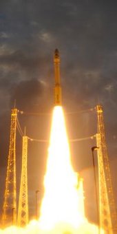
Launched by a Vega rocket from French Guiana in the early hours of 7 May along with two other satellites, Proba-V was the first of the three passengers to be deployed into its Sun-synchronous near-polar orbit at 820 km altitude, just 55 minutes after launch.
Liftoff of Vega VV02
The effort to bring the minisatellite to life began immediately – known as the Launch and Early Operations Phase, or LEOP, overseen from Redu, where the satellite is controlled from and monitored during its mission.
“The first LEOP milestone was to check the first signs of life from the satellite as it flew over the ESA ground station at Kourou 40 minutes after separation,” explained Karim Mellab, Proba-V Project Manager.
“Then a full telemetry session confirmed the stabilisation of the satellite’s attitude, or pointing direction. The onboard computer used ‘magnetorquers’ – basically magnets interacting with Earth’s magnetic field – to control the satellite’s attitude and compensate for the spin imparted by the separation.
“Since then, we have been checking the various subsystems one by one, confirming that they have made it through the stress of launch in working order.
“These initial checks are now being followed by a diligent commissioning of every single detail of the overall system platform, instrument and technology demonstration payloads, which will take the next few months.”
This will include a careful cross-calibration of the Vegetation imager with the previous generation of the instrument, operating aboard France’s Spot-5 satellite, to ensure data compatibility.
Proba-V is a miniaturised ESA vegetation mapper
Less than a cubic metre in volume, Proba-V is a miniaturised ESA satellite tasked with a full-scale mission: to map land cover and vegetation growth across the entire planet every two days.
Proba-V is flying a lighter but fully functional redesign of the Vegetation imaging instruments previously flown aboard France’s full-sized Spot-4 and Spot-5 satellites, which have been observing Earth since 1998.
The minisatellite will provide data to the instrument’s worldwide user community of scientists and service providers as soon as its orbital commissioning – including cross-checks with Spot-5’s Vegetation instrument – is complete and the mission is turned over from ESA’s Directorate of Technical and Quality Management to the Agency’s Earth Observation Programme.
Vital uses of Proba-V Vegetation data include day-by-day tracking of extreme weather, alerting authorities to crop failures, monitoring inland water resources and tracing the steady spread of deserts and deforestation.
Proba-V is the latest addition to the Proba family of small space missions, giving flight experience to promising European technologies. So along with hosting its main instrument, Proba-V also provides early test flights for a variety of advanced ‘guest payloads’.
These comprise a detector to track aircraft in flight around the world, two radiation monitors, a communication amplifier based on high-performance semiconductor gallium nitride and an experiment testing fibre optics for space.

VEGA
Liftoff of Vega VV01
VV01 liftoff

Main Data Vega
Height 30 m
Diameter 3 m
Liftoff mass 137 tonnes
Payload mass* 1500 kg
 
Although there is a growing tendency for satellites to become larger, there is still a need for a small launcher to place 300–2000 kg satellites, economically, into the polar and low-Earth orbits used for many scientific and Earth observation missions.
Europe’s answer to these needs is Vega, named after the second brightest star in the northern hemisphere. Vega will make access to space easier, quicker and cheaper.
Costs are being kept to a minimum by using advanced low-cost technologies and by introducing an optimised synergy with existing production facilities used for Ariane launchers.
Vega is a single-body launcher with three solid-propellant stages and a liquid-propellant upper module for attitude and orbit control, and satellite release. Unlike most small launchers, Vega is able to place multiple payloads into orbit.
Development of the launcher started in 1998. The first Vega lifted off on 13 February 2012 on a flawless qualification flight from Europe’s Spaceport in French Guiana, where the Ariane 1 launch facilities have been adapted for its use.
The second Vega launch took place on 7 May 2013 from French Guiana. It marks the transition into commercial exploitation while still completing its qualification. This launcher with increased capabilities and flexibility is designed to meet the demands of the launchers market.
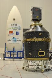
Proba-V on Vespa adapter
The extended capabilities of Vega beyond the mission that was performed in the VV01 qualification flight have been made possible in part by the addition of Vespa (VEga Secondary Payload Adapter). Vespa allows for multiple payloads and their deployment into different orbits.
Compared to the first Vega launch, with VV02 there was a change in both inclination and orbit for the satellites. This is a complex procedure and resulted in a much longer mission – at 160 minutes it is more than double that of VV01.
Proba-V was the first payload released by Vespa into a Sun-synchronous polar orbit at 820 km altitude and an inclination of 98.73°. At this point, the Vespa adapter separated and Vega then, through a series of five burns and coasts, moved into a second orbit at 668 km altitude and an inclination of 98.13° for the second deployment of the two remaining payloads. 
A final burn will deorbit the upper stage to ensure that it does not remain as a debris threat. 
In addition to the Vespa adapter, this second Vega launcher also has new flight software.
To receive telemetry during the early phase of the flight, a new ground station has been built in the north of French Guiana. 
This was the first Vega launch operated by Arianespace on behalf of ESA, although ESA still remains responsible for the mission.
* Launch in circular orbit, 90°inclination, 700 km
Last update: 10 May 2013
Vega (Vettore Europeo di Generazione Avanzata)
Guillermo Gonzalo Sánchez Achutegui
ayabaca@gmail.com
ayabaca@yahoo.com
ayabaca@yahoo.com

Image of the week: This Landsat image features the Clearwater Lakes in Canada’s Quebec province


This Landsat image from 9 September 2010 features the Clearwater Lakes in Canada’s Quebec province. Located to the east of the Hudson Bay, what appears to be two separate lakes is actually a single body of water that fills two depressions. The depressions were created by two meteorite impacts, believed to have hit Earth simultaneously up to 290 million years ago. The name 'Clearwater Lakes' comes from the clarity of its water.
ESA supports the Landsat series as a Third Party Mission, meaning it uses its ground infrastructure and expertise to acquire, process and distribute Landsat data to users.
This image is featured on the Earth from Space video programme.

This Landsat image from 9 September 2010 features the Clearwater Lakes in Canada’s Quebec province.
Located to the east of the Hudson Bay, what appears to be two separate lakes is actually a single body of water that fills two depressions. The depressions were created by two meteorite impacts, believed to have hit Earth simultaneously up to 290 million years ago.
The larger of the two to the northwest is about 36 km in diameter and has a ring of islands in the centre. The smaller is about 26 km in diameter. A string of islands separate the two water-filled craters.
The name 'Clearwater Lakes' comes from the clarity of its water.
The surrounding terrain is dotted with smaller lakes and rivers. The topography of this area, known as the Canadian Shield, was shaped by the huge ice sheets and glaciers from the last ice ages covering the area up to 15 000 years ago.
The Thematic Mapper on Landsat-5 is jointly managed by NASA and the US Geological Survey. ESA supports the Landsat series as a Third Party Mission, meaning it uses its ground infrastructure and expertise to acquire, process and distribute Landsat data to users.
This image is featured on the Earth from Space video programme.
ESA
Guillermo Gonzalo Sánchez Achutegui
ayabaca@gmail.com
ayabaca@hotmail.com
ayabaca@yahoo.com

ESA - First new Galileo satellite arrives at ESA for space testing


First Galileo FOC satellite arrives at ESTEC for space testing
16 May 2013 The first satellite of Galileo’s next phase has arrived at ESA’s technical heart in the Netherlands for a rigorous set of tests to check its readiness for launch.
This first Galileo Full Operational Capability – FOC – satellite is functionally identical to the first four Galileo In-Orbit Validation satellites already in orbit, the operational nucleus of the full Galileo constellation, but has been built by a separate industrial team.
Like all the other 21 FOC satellites so far procured by ESA, the satellite’s prime contractor is OHB in Bremen, Germany and the navigation payload was produced by Surrey Satellite Technology Ltd in Guildford, UK.
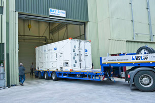
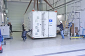
This first FOC satellite arrived by road at ESTEC’s Test Centre in Noordwijk, the Netherlands, on 15 May to undergo a series of tests simulating different aspects of launch and space environment. The comprehensive test programme will validate the new design and all the satellites to follow.
A unique facility for Europe, ESA’s test centre has all the facilities needed to validate a satellite for launch under a single roof.
Thermal vacuum testing will simulate the temperature extremes the satellites must endure in the airlessness of space throughout their 12-year working lifetimes. Without any moderating atmosphere, temperatures can shift hundreds of degrees from sunlight to shadow.
First Galileo FOC satellite arrives at ESTEC for space testing.
Other activities on the schedule include shaker and acoustic noise testing – simulating the vibration and noise of launch – as well as electromagnetic compatibility and antenna testing, placing the satellite in chambers shielded from all external radio signals to reproduce infinite space and check that its various antennas and electrical systems are interoperable without harmful interference.
Each satellite will offer the full range of Galileo positioning, navigation and timing services, plus search and rescue message relays, their accuracy ensured by onboard atomic clocks kept synchronised by a worldwide ground network.
“The Galileo FOC satellites provide the same capabilities as the previous IOV satellites, but with improved performance, such as higher transmit power,” explains Giuliano Gatti, the Head of the Galileo Space Segment Procurement Office. “They are to all intents a new design that requires a full checkout before getting the green light for launch.
“By fully validating this satellite, the second flight model due to follow it here at beginning of June, and the third one due to arrive in ESTEC at middle of July, we gain full knowledge of their characteristics, and the further satellites in the series will require less rigorous functional testing.”
The first four Galileo IOV satellites, launched in 2011 and 2012, were provided by EADS Astrium with Thales Alenia Space Italy responsible for integrating the satellites and Astrium in Portsmouth, UK, providing the navigation payloads. They provided their first navigation fix in March 2013.
The first FOC satellites are due to be launched together on a Soyuz from Europe’s Spaceport in Kourou, French Guiana this autumn, with two more due to follow by the end of the year.
The definition, development and In-Orbit Validation phases of the Galileo programme are being carried out by ESA and co-funded with the European Commission (EC).
The subsequent FOC phase is managed and funded by the EC. The Commission has delegated the role of design and procurement agent to ESA for the FOC phase. At the same time as the satellites are being assembled on a production-line basis, ground stations are also being established on far-flung European territories around the globe.

European Space Research and Technology Centre (ESTEC) - ESA

ESA has sites in several European countries, but the European Space Research and Technology Centre (ESTEC) in Noordwijk, the Netherlands, is the largest. ESTEC is our technical heart - the incubator of the European space effort - where most ESA projects are born and where they are guided through the various phases of development.
  • Developing and managing all types of ESA missions: science, exploration, telecommmunications, human spaceflight, satellite navigation and Earth observation.
  • Providing all the managerial and technical competences and facilities needed to initiate and manage the development of space systems and technologies.
  • Operating an environmental test centre for spacecraft, with supporting engineering laboratories specialised in systems engineering, components and materials, and working within a network of other facilities and laboratories.
  • Supporting European space industry and working closely with other organisations, such as universities, research institutes and national agencies from ESA Member States, and cooperating with space agencies all over the world.

ESTEC is located in Noordwijk, the Netherlands. Our postal address is:
European Space Research & Technology Centre
Postbus 299
2200 AG Noordwijk (The Netherlands)
Tel: +31 (0)71 565 6565
If you want to get in touch with ESTEC via ESA, please send your question to contactesa @ esa.int.
Last update: 23 March 2010
ESA
Guillermo Gonzalo Sánchez Achutegui
ayabaca@gmail.com
ayabaca@hotmail.com
ayabaca@yahoo.com

NASA - Black Hole-Powered Jets Plow Into Galaxy


Composite image of 4C29.30, a galaxy located some 850 million light years from Earth

This composite image of a galaxy illustrates how the intense gravity of a supermassive black hole can be tapped to generate immense power. The image contains X-ray data from NASA's Chandra X-ray Observatory (blue), optical light obtained with the Hubble Space Telescope (gold) and radio waves from the NSF’s Very Large Array (pink).

This multi-wavelength view shows 4C+29.30, a galaxy located some 850 million light years from Earth. The radio emission comes from two jets of particles that are speeding at millions of miles per hour away from a supermassive black hole at the center of the galaxy. The estimated mass of the black hole is about 100 million times the mass of our Sun. The ends of the jets show larger areas of radio emission located outside the galaxy.

The X-ray data show a different aspect of this galaxy, tracing the location of hot gas. The bright X-rays in the center of the image mark a pool of million-degree gas around the black hole. Some of this material may eventually be consumed by the black hole, and the magnetized, whirlpool of gas near the black hole could in turn, trigger more output to the radio jet.

Most of the low-energy X-rays from the vicinity of the black hole are absorbed by dust and gas, probably in the shape of a giant doughnut around the black hole. This doughnut, or torus blocks all the optical light produced near the black hole, so astronomers refer to this type of source as a hidden or buried black hole. The optical light seen in the image is from the stars in the galaxy.

The bright spots in X-ray and radio emission on the outer edges of the galaxy, near the ends of the jets, are caused by extremely high energy electrons following curved paths around magnetic field lines. They show where a jet generated by the black hole has plowed into clumps of material in the galaxy (mouse over the image for the location of these bright spots). Much of the energy of the jet goes into heating the gas in these clumps, and some of it goes into dragging cool gas along the direction of the jet. Both the heating and the dragging can limit the fuel supply for the supermassive black hole, leading to temporary starvation and stopping its growth. This feedback process is thought to cause the observed correlation between the mass of the supermassive black hole and the combined mass of the stars in the central region or bulge or a galaxy.

These results were reported in two different papers. The first, which concentrated on the effects of the jets on the galaxy, is available online and was published in the May 10, 2012 issue of The Astrophysical Journal. It is led by Aneta Siemiginowska from the Harvard-Smithsonian Center for Astrophysics (CfA) in Cambridge, MA and the co-authors are Łukasz Stawarz, from the Institute of Space and Astronautical Science in Yoshinodai, Japan; Teddy Cheung from the National Academy of Sciences in Washington, DC; Thomas Aldcroft from CfA; Jill Bechtold from University of Arizona in Tucson, AZ; Douglas Burke from CfA; Daniel Evans from CfA; Joanna Holt from Leiden University in Leiden, The Netherlands; Marek Jamrozy from Jagiellonian University in Krakow, Poland; and Giulia Migliori from CfA. The second, which concentrated on the supermassive black hole, is available online and was published in the October 20, 2012 issue of The Astrophysical Journal. It is led by Malgorzata Sobolewska from CfA, and the co-authors are Aneta Siemiginowska, Giulia Migliori, Łukasz Stawarz, Marek Jamrozy, Daniel Evans, and Teddy Cheung.

NASA's Marshall Space Flight Center in Huntsville, Ala., manages the Chandra program for NASA's Science Mission Directorate in Washington. The Smithsonian Astrophysical Observatory controls Chandra's science and flight operations from Cambridge, Mass.

Credits: X-ray: NASA/CXC/SAO/A. Siemiginowska et al; Optical: NASA/STScI; Radio: NSF/NRAO/VLA

› Read more/access all images
› Chandra's Flickr photoset
 
 
J.D. Harrington, 202-358-0321
Headquarters, Washington
j.d.harrington@nasa.gov

Janet Anderson, 256-544-0034
Marshall Space Flight Center, Huntsville, Ala.
janet.l.anderson@nasa.gov

Megan Watzke 617-496-7998
Chandra X-ray Center, Cambridge, Mass.
mwatzke@cfa.harvard.edu
NASA
Guillermo Gonzalo Sánchez Achutegui
ayabaca@gmail.com
ayabaca@hotmail.com
ayabaca@yahoo.com

NASA - NASA Extends Environmental Testing and Integration Services Contract at Goddard

GREENBELT, Md. -- NASA has extended a contract with Analex Corporation of Fairfax, Va., for Environmental Testing and Integration Services at the agency's Goddard Space Flight Center in Greenbelt, Md.

This extension increases the maximum ordering value of the cost-plus award-fee indefinite-delivery, indefinite-quantity contract by $81.1 million to $328.1 million. The period of performance is from May 15 to Sept. 30, 2014.

Analex will continue to provide Goddard with engineering and technician testing and integration support services for the study, design, development, fabrication, integration, testing, verification and operations of space flight and ground system hardware. The contractor also will support software and operations of facilities that help develop spaceflight hardware at Goddard.

For information about NASA and agency programs, visit:

Frigid Heat: How Ice can Menace a Hot Engine
05.14.13
 
Judy Van Zante, NASA Glenn icing cloud specialist, was the first person to calibrate the high altitude ice crystal cloud environment necessary to cause a loss of engine power during an engine test in the PSL. 
Judy Van Zante, NASA Glenn icing cloud specialist, was the first person to calibrate the high altitude ice crystal cloud environment necessary to cause a loss of engine power during an engine test in the PSL. Image credit: NASA
›  View Larger Image

The Propulsion Systems Laboratory at NASA Glenn has been configured to recreate ice crystal clouds at the high altitude flight conditions for full-scale engine tests. 
The Propulsion Systems Laboratory at NASA Glenn has been configured to recreate ice crystal clouds at the high altitude flight conditions for full-scale engine tests. Image credit: NASA
›  View Larger Image

How does ice accumulate inside hot turbofan jet engines during flight? NASA scientists, working with engine manufacturers, are closer to answering that question thanks to the only test facility in the world capable of creating a high altitude ice crystal cloud during a full-scale engine test at the Glenn Research Center.

Over the last 20 years, more than 200 incidents have been documented of turbofan jet engines losing power during high-altitude flights, even though pilots observed little to no inclement weather. For many of these incidents, the aircraft were flying in the vicinity of deep convective storm clouds with only light rain on the windshield. Due to the lack of liquid water content at these high altitudes, it was thought that ice crystals were hitting and melting on the heated windshields of the aircraft.

Investigators have developed a theory that the aircraft are flying through dense clouds of small ice crystals. The crystals are ingested into the engines where they melt on the warm surfaces inside the engines. The surfaces eventually become cold enough during flight that ice can begin to build up, or accrete, which can affect the normal operation of the engine. This is known as ice crystal icing.

Ice crystal clouds occur near deep convective thunderstorms where warm moist air rapidly rises and water vapor condenses forming liquid water particles that freeze and flow out of the top of the cloud. The ice crystals can travel up to 30 nautical miles away from the main storm. Pilots are instructed to fly around these storms, but the distance may not be far enough to avoid the far reach of the ice crystal clouds.

"Ice crystals are thought to bounce off colder than freezing hardware and that warmer than freezing hardware would not accrete ice," says Michael Oliver, aerospace engineer and research lead on the project. "But we are finding that a combination of ice and water on these surfaces is able to cool down the hardware to the point where ice can accrete."

Understanding how a constant flow of warm air inside the engine interacts with a constant flow of ice crystals has challenged conventional theories. "We are now investigating the physics of ice crystal icing. For instance, whether or not a water layer coats warmer than freezing surfaces of the engine or heated sensors at first and allows ice crystals to accumulate leading to cooling of the surfaces and ice accretion," explains Oliver. Up until recently, engine manufacturers could only perform component tests to investigate their high altitude ice crystal icing theories, but recreating the desired conditions and measuring the results was difficult and expensive.
This animation shows how ice accretion can occur when an airplane, with a turbofan engine, travels through a high altitude ice crystal cloud.

Earlier this year, however, NASA Glenn researchers were able to re-create the high altitude ice crystal cloud environment in the Propulsion Systems Laboratory (PSL) during a full-scale engine test, which resulted in a loss of engine power. For the first time ever, scientists calibrated to a very fine degree, ice crystal clouds found at the high altitude and pressure conditions typical in flight.

"The big question was, can we simulate the right aspects of the ice crystal cloud that causes the power loss?" says Judy Van Zante, icing cloud specialist. "We cannot vary the shape of the ice particles, but our specially-designed spray bars allow us to control the size and total amount of ice in the cloud."

"These crystals can flow into the hot compression system of a turbofan engine and accrete internally. What we are able to do in the PSL is simulate a high altitude ice crystal environment. With the controlled environment, we can study where and how the ice is accumulating," she says.

Glenn is working with industry to address this aviation issue by establishing a capability that will allow engines to be operated at the same temperature and pressure conditions experienced in flight, while ingesting ice particles.

The information gained through performing these tests will also be used to establish test methods and techniques for the study of engine ice crystal icing in new and existing commercial engines. It will also help develop validation data sets required for advanced computer codes that can be specifically applied to assess an engine's susceptibility to ice crystal icing in terms of safety, performance and operability.
-Nancy Smith Kilkenny, SGT Inc.
NASA's Glenn Research Center
 NASA
Guillermo Gonzalo Sánchez Achutegui
ayabaca@gmail.com
ayabaca@hotmail.com
ayabaca@yahoo.com

NASA - Astronaut Chris Cassidy


NASA - NASA Satellite Data Help Pinpoint Glaciers' Role in Sea Level Rise


› View larger
The Aletsch Glacier in Switzerland is the largest valley glacier in the Alps and it has been losing mass since the mid-19th century. A new study using data from two NASA satellites found that glaciers like this one lost an average of 571 trillion pounds of ice per year from 2003 to 2009, which contributed to about 30 percent of the total observed global sea level rise during the same period. Credit: Frank Paul, University of Zurich.

A new study of glaciers worldwide using observations from two NASA satellites has helped resolve differences in estimates of how fast glaciers are disappearing and contributing to sea level rise.

The new research found glaciers outside of the Greenland and Antarctic ice sheets, repositories of 1 percent of all land ice, lost an average of 571 trillion pounds (259 trillion kilograms) of mass every year during the six-year study period, making the oceans rise 0.03 inches (0.7 mm) per year. This is equal to about 30 percent of the total observed global sea level rise during the same period and matches the combined contribution to sea level from the Greenland and Antarctica ice sheets.

The study compares traditional ground measurements to satellite data from NASA's Ice, Cloud, and Land Elevation Satellite (ICESat) and Gravity Recovery and Climate Experiment (GRACE) missions to estimate ice loss for glaciers in all regions of the planet. The study period spans 2003 to 2009, the years when the two missions overlapped.

"For the first time, we have been able to very precisely constrain how much these glaciers as a whole are contributing to sea level rise," said Alex Gardner, Earth scientist at Clark University in Worcester, Mass., and lead author of the study. "These smaller ice bodies are currently losing about as much mass as the ice sheets."

The study was published Thursday in the journal Science.

NASA Satellite Data Help Pinpoint Glaciers' Role in Sea Level Rise
 
 WASHINGTON -- A new study of glaciers worldwide using observations from two NASA satellites has helped resolve differences in estimates of how fast glaciers are disappearing and contributing to sea level rise.

The new research found glaciers outside of the Greenland and Antarctic ice sheets, repositories of 1 percent of all land ice, lost an average of 571 trillion pounds (259 trillion kilograms) of mass every year during the six-year study period, making the oceans rise 0.03 inches (0.7 mm) per year. This is equal to about 30 percent of the total observed global sea level rise during the same period and matches the combined contribution to sea level from the Greenland and Antarctica ice sheets.

The study compares traditional ground measurements to satellite data from NASA's Ice, Cloud, and Land Elevation Satellite (ICESat) and Gravity Recovery and Climate Experiment (GRACE) missions to estimate ice loss for glaciers in all regions of the planet. The study period spans 2003 to 2009, the years when the two missions overlapped.

"For the first time, we have been able to very precisely constrain how much these glaciers as a whole are contributing to sea level rise," said Alex Gardner, Earth scientist at Clark University in Worcester, Mass., and lead author of the study. "These smaller ice bodies are currently losing about as much mass as the ice sheets."

The study was published Thursday in the journal Science.

ICESat, which stopped operating in 2009, measured glacier change through laser altimetry, which bounces lasers pulses off the ice surface to inform the satellite of changes in the height of the ice cover. ICESat's successor, ICESat-2, is scheduled to launch in 2016. GRACE, still operational, detects variations in Earth's gravity field resulting from changes in the planet's mass distribution, including ice displacements.

The new research found all glacial regions lost mass from 2003 to 2009, with the biggest ice losses occurring in Arctic Canada, Alaska, coastal Greenland, the southern Andes and the Himalayas. In contrast, Antarctica's peripheral glaciers -- small ice bodies not connected to the main ice sheet -- contributed little to sea level rise during that period. The study builds on a 2012 study using only GRACE data that also found glacier ice loss was less than estimates derived from ground-based measurements.

Current estimates predict all the glaciers in the world contain enough water to raise sea level by as much as 24 inches (about 60 centimeters). In comparison, the entire Greenland ice sheet has the potential to contribute about 20 feet (about 6 meters) to sea level rise and the Antarctic ice sheet just less than 200 feet (about 60 meters).

"Because the global glacier ice mass is relatively small in comparison with the huge ice sheets covering Greenland and Antarctica, people tend to not worry about it," said study co-author Tad Pfeffer, a glaciologist at the University of Colorado in Boulder. "But it's like a little bucket with a huge hole in the bottom: it may not last for very long, just a century or two, but while there's ice in those glaciers, it's a major contributor to sea level rise."

To make ground-based estimates of glacier mass changes, glaciologists perform on-site measurements along a line from a glacier's summit to its edge. Scientists extrapolate these measurements to the entire glacier area and carry them out for several years to estimate the glacier's overall mass change over time. While this type of measurement does well for small, individual glaciers, it tends to overestimate ice loss when the findings are extrapolated to larger regions, such as entire mountain ranges.

"Ground observations often can only be collected for the more accessible glaciers, where it turns out thinning is occurring more rapidly than the regional averages," Gardner said. "That means when those measurements are used to estimate the mass change of the entire region, you end up with regional losses that are too great."

GRACE does not have fine enough resolution and ICESat does not have sufficient sampling density to study small glaciers, but the two satellites' estimates of mass change for large glaciered regions agree well, the study concluded.

"We now have a lot more data for the glacier-covered regions because of GRACE and ICESat," said Gardner. "Without having these independent observations, there was no way to tell that the ground observations were biased."

The research involved 16 researchers from 10 countries, with major contributions from Clark University, the University of Michigan, Scripps Institution of Oceanography in San Diego, Trent University in Ontario, the University of Colorado at Boulder and the University of Alaska Fairbanks.

For images of glaciers studied for this paper, visit:

For information about NASA and agency programs, visit:

NASA
Guillermo Gonzalo Sánchez Achutegui
ayabaca@gmail.com
ayabaca@hotmail.com
ayabaca@yahoo.com