 (868.02 kB
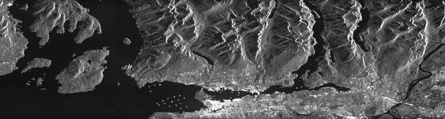
This radar image of Vancouver harbour was acquired by Canada’s Radarsat-2. Owned and operated by McDonald, Dettwiler and Associates, Radarsat-2 was carefully reprogrammed to match the way Europe’s upcoming Sentinel-1satellite will image Earth and show the quality of images that can be expected.-
Those who need satellite data for a wide range of applications, from mapping sea ice and tracking maritime traffic to monitoring geohazards over land, are eagerly awaiting the launch of Sentinel-1. ESA is helping users get ahead of the game by offering test data and simulated images.
To be launched later this year, Sentinel-1 is the first of five satellite missions dedicated to supplying a stream of data for Europe’s Global Monitoring for Environment and Security ‘Copernicus’ programme.
This particular satellite will provide timely high-quality radar images of our planet’s surface to support European operational services that use Earth observation data in areas such as emergency response, marine and land monitoring, civil security and climate studies.

Sentinel-1
An important step forward in this respect is the availability of simulated products and documentation to users. ESA is responding to these needs in two ways.
Firstly, ESA has just released a sample of Sentinel-1 simulated user products and associated format and product definition documents to GMES users. In addition, the Agency is planning a further distribution to all potential users in the coming weeks.
Simulated Sentinel-1 data
Notably, these products were generated by a preliminary version of Sentinel-1’s operational Instrument Processing Facility.
Though they are not intended to reflect the final characteristics of the user products, the format and contents are representative of what the mission will offer.
This will evolve with new versions of the facility and may be slightly tuned following system qualification and inflight commissioning.
Joel Dorandeu from MyOcean said, “We very much welcome the efforts being made to help service providers such as us prepare for the new data from Sentinel-1.
“Considering the volumes of data we expect from Sentinel-1 along with its method of acquisition we have the challenge of developing new processing chains.
“We are now eager to start simulating our products."
To complement this initial release of test data, ESA is, in parallel, simulating Sentinel-1 acquisitions from space using Canada’s Radarsat-2 satellite.
Vancouver radar image
This initiative is now starting to bear fruit following the first full simulation of a Sentinel-1 radar image as shown in picture at the top and here on the left.
Thanks to its owner and operator, McDonald, Dettwiler and Associates, Radarsat-2 was carefully reprogrammed to match the way Sentinel-1 will be operated. A remarkable achievement is the fact that Radarsat was able to emulate the way Sentinel-1 images Earth’s surface using a method called TOPS, thus providing a quality of image almost exactly the same as Sentinel-1.
The very first results are promising, as can be seen in the images
acquired over Vancouver harbour on the west coast of Canada. The city is
clearly visible, as are the ships docked in the harbour, the coastline
and the nearby mountain ranges.
The acquisition of more images over specific test sites are planned to demonstrate the suitability of Sentinel-1 for classifying sea-ice, for applications using ocean winds and waves, and for detecting ships, thereby preparing users for the uptake of data.
Dedicated acquisitions of image pairs and data stacks suitable for measuring surface movements such as glacier dynamics and subsidence are also planned to take place in the coming months.
As for the current set of test data, the Radarsat-2 simulated images will also be processed and formatted using the Sentinel-1 Instrument Processing Facility and made available to users shortly.
The Sentinel-1 mission is a polar-orbiting satellite system for the
continuation of Synthetic Aperture Radar (SAR) operational applications.
Sentinel-1 is a C-band imaging radar mission to provide an all-weather day-and-night supply of imagery for GMES user services. The first Sentinel-1 satellite is envisaged to launch in 2013 and will be followed by the second satellite a few years later.
Dedicated to GMES, Sentinel-1 will ensure the continuity of C-band SAR data, building on ESA’s and Canada’s heritage SAR systems on ERS-1, ERS-2, Envisat and Radarsat.
The SAR sensor will operate in two main modes: Interferometric Wide Swath and Wave. The first has a swath width of 250 km and a ground resolution of 5×20 m. These two modes will satisfy most of the envisaged service requirements. Two other mutually exclusive modes are provided for continuity with other SAR missions and to accommodate emerging user requirements.
Sentinel-1's revisit time, geographical coverage and rapid data dissemination are key to providing essential data for GMES. The Sentinel-1 pair is expected to provide coverage over Europe, Canada and main shipping routes in 1–3 days, regardless of weather conditions. Radar data will be delivered within an hour of acquisition – a big improvement over existing SAR systems.
 The mission will benefit numerous services. For example, services that
relate to the monitoring of Arctic sea-ice extent, routine sea-ice
mapping, surveillance of the marine environment, including oil-spill
monitoring and ship detection for maritime security, monitoring
land-surface for motion risks, mapping for forest, water and soil
management and mapping to support humanitarian aid and crisis
situations.
The mission will benefit numerous services. For example, services that
relate to the monitoring of Arctic sea-ice extent, routine sea-ice
mapping, surveillance of the marine environment, including oil-spill
monitoring and ship detection for maritime security, monitoring
land-surface for motion risks, mapping for forest, water and soil
management and mapping to support humanitarian aid and crisis
situations.
The design of the Sentinel-1 mission with its focus on reliability, operational stability, global coverage, consistent operations and quick data delivery is expected to enable the development of new applications and meet the evolving needs of GMES.
The acquisition of more images over specific test sites are planned to demonstrate the suitability of Sentinel-1 for classifying sea-ice, for applications using ocean winds and waves, and for detecting ships, thereby preparing users for the uptake of data.
Dedicated acquisitions of image pairs and data stacks suitable for measuring surface movements such as glacier dynamics and subsidence are also planned to take place in the coming months.
As for the current set of test data, the Radarsat-2 simulated images will also be processed and formatted using the Sentinel-1 Instrument Processing Facility and made available to users shortly.
Sentinel-1
Sentinel-1 is a C-band imaging radar mission to provide an all-weather day-and-night supply of imagery for GMES user services. The first Sentinel-1 satellite is envisaged to launch in 2013 and will be followed by the second satellite a few years later.
Dedicated to GMES, Sentinel-1 will ensure the continuity of C-band SAR data, building on ESA’s and Canada’s heritage SAR systems on ERS-1, ERS-2, Envisat and Radarsat.
The SAR sensor will operate in two main modes: Interferometric Wide Swath and Wave. The first has a swath width of 250 km and a ground resolution of 5×20 m. These two modes will satisfy most of the envisaged service requirements. Two other mutually exclusive modes are provided for continuity with other SAR missions and to accommodate emerging user requirements.
Sentinel-1's revisit time, geographical coverage and rapid data dissemination are key to providing essential data for GMES. The Sentinel-1 pair is expected to provide coverage over Europe, Canada and main shipping routes in 1–3 days, regardless of weather conditions. Radar data will be delivered within an hour of acquisition – a big improvement over existing SAR systems.
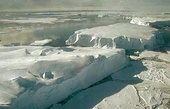
Sentinel-1 will aid sea-ice monitoring
The design of the Sentinel-1 mission with its focus on reliability, operational stability, global coverage, consistent operations and quick data delivery is expected to enable the development of new applications and meet the evolving needs of GMES.
Sentinel-1 is being realised by an industrial consortium led by Thales
Alenia Space Italy as Prime Contractor, with Astrium Germany responsible
for the C-SAR payload incorporating the central radar electronics
subsystem developed by Astrium UK.
Sentinel-1 will be launched on a Soyuz rocket from Europe's Spaceport in French Guiana.
ESASentinel-1 will be launched on a Soyuz rocket from Europe's Spaceport in French Guiana.
Guillermo Gonzalo Sánchez Achutegui
ayabaca@gmail.com
ayabaca@hotmail.com
ayabaca@yahoo.com
No hay comentarios:
Publicar un comentario