Mostrando entradas con la etiqueta European Galileo satellites. Mostrar todas las entradas

domingo, 19 de mayo de 2013

ESA - First new Galileo satellite arrives at ESA for space testing


First Galileo FOC satellite arrives at ESTEC for space testing
16 May 2013 The first satellite of Galileo’s next phase has arrived at ESA’s technical heart in the Netherlands for a rigorous set of tests to check its readiness for launch.
This first Galileo Full Operational Capability – FOC – satellite is functionally identical to the first four Galileo In-Orbit Validation satellites already in orbit, the operational nucleus of the full Galileo constellation, but has been built by a separate industrial team.
Like all the other 21 FOC satellites so far procured by ESA, the satellite’s prime contractor is OHB in Bremen, Germany and the navigation payload was produced by Surrey Satellite Technology Ltd in Guildford, UK.
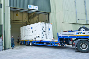
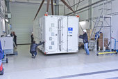
This first FOC satellite arrived by road at ESTEC’s Test Centre in Noordwijk, the Netherlands, on 15 May to undergo a series of tests simulating different aspects of launch and space environment. The comprehensive test programme will validate the new design and all the satellites to follow.
A unique facility for Europe, ESA’s test centre has all the facilities needed to validate a satellite for launch under a single roof.
Thermal vacuum testing will simulate the temperature extremes the satellites must endure in the airlessness of space throughout their 12-year working lifetimes. Without any moderating atmosphere, temperatures can shift hundreds of degrees from sunlight to shadow.
First Galileo FOC satellite arrives at ESTEC for space testing.
Other activities on the schedule include shaker and acoustic noise testing – simulating the vibration and noise of launch – as well as electromagnetic compatibility and antenna testing, placing the satellite in chambers shielded from all external radio signals to reproduce infinite space and check that its various antennas and electrical systems are interoperable without harmful interference.
Each satellite will offer the full range of Galileo positioning, navigation and timing services, plus search and rescue message relays, their accuracy ensured by onboard atomic clocks kept synchronised by a worldwide ground network.
“The Galileo FOC satellites provide the same capabilities as the previous IOV satellites, but with improved performance, such as higher transmit power,” explains Giuliano Gatti, the Head of the Galileo Space Segment Procurement Office. “They are to all intents a new design that requires a full checkout before getting the green light for launch.
“By fully validating this satellite, the second flight model due to follow it here at beginning of June, and the third one due to arrive in ESTEC at middle of July, we gain full knowledge of their characteristics, and the further satellites in the series will require less rigorous functional testing.”
The first four Galileo IOV satellites, launched in 2011 and 2012, were provided by EADS Astrium with Thales Alenia Space Italy responsible for integrating the satellites and Astrium in Portsmouth, UK, providing the navigation payloads. They provided their first navigation fix in March 2013.
The first FOC satellites are due to be launched together on a Soyuz from Europe’s Spaceport in Kourou, French Guiana this autumn, with two more due to follow by the end of the year.
The definition, development and In-Orbit Validation phases of the Galileo programme are being carried out by ESA and co-funded with the European Commission (EC).
The subsequent FOC phase is managed and funded by the EC. The Commission has delegated the role of design and procurement agent to ESA for the FOC phase. At the same time as the satellites are being assembled on a production-line basis, ground stations are also being established on far-flung European territories around the globe.

European Space Research and Technology Centre (ESTEC) - ESA

ESA has sites in several European countries, but the European Space Research and Technology Centre (ESTEC) in Noordwijk, the Netherlands, is the largest. ESTEC is our technical heart - the incubator of the European space effort - where most ESA projects are born and where they are guided through the various phases of development.
  • Developing and managing all types of ESA missions: science, exploration, telecommmunications, human spaceflight, satellite navigation and Earth observation.
  • Providing all the managerial and technical competences and facilities needed to initiate and manage the development of space systems and technologies.
  • Operating an environmental test centre for spacecraft, with supporting engineering laboratories specialised in systems engineering, components and materials, and working within a network of other facilities and laboratories.
  • Supporting European space industry and working closely with other organisations, such as universities, research institutes and national agencies from ESA Member States, and cooperating with space agencies all over the world.

ESTEC is located in Noordwijk, the Netherlands. Our postal address is:
European Space Research & Technology Centre
Postbus 299
2200 AG Noordwijk (The Netherlands)
Tel: +31 (0)71 565 6565
If you want to get in touch with ESTEC via ESA, please send your question to contactesa @ esa.int.
Last update: 23 March 2010
ESA
Guillermo Gonzalo Sánchez Achutegui
ayabaca@gmail.com
ayabaca@hotmail.com
ayabaca@yahoo.com

domingo, 14 de abril de 2013

ESA - ESA’s telecom and navigation vehicle ready for test driving


Telecommunications and Navigation Testbed Vehicle
11 April 2013 The radio spectrum is about to get even busier, as Europe’s Galileo satnav system starts services, at the same time as ESA trials novel satellite-based telecommunication services. Supporting these developments from the ground, ESA’s new custom-built Telecommunications and Navigation Testbed Vehicle will measure the resulting signals from all over Europe.
Adapted from a Mercedes Benz Sprinter van, this unique measurement vehicle has been delivered to ESTEC by Austria’s Joanneum Research institute.
“This is a dual-purpose vehicle, suitable for both telecommunications and navigation system testing,” explained Simon Johns of ESA’s Radionavigation Systems and Techniques Section.
“For navigation, we have the Galileo constellation coming on stream, as well as the stepping up of ESA’s GNSS Evolution programme – designing what comes next after Galileo’s first generation.”
The four wheel-drive vehicle can host a three-person team, and is crammed with dedicated navigation and telecommunication monitoring equipment. 
Testbed Vehicle screen
“One of the main goals driving the design was to have an 'easy to adapt' test platform suitable to set up test campaigns for different mobile satellite systems and standards that would require different types of antennas and specific receiver/transmit equipment,” explained Olivier Smeyers of ESA’s Communication-TT&C Systems and Techniques Section.
“On the telecommunications side, there is a continuous effort to enhance current and create new mobile satellite-based broadcast and interactive services via the evolution of current systems or developing new standards.
“Testing in the field is an essential element for validating and eventually establishing evolved or new standards.
“The vehicle has built-in multimedia equipment, including storage and control computers, multimedia gateway, passenger LCD screens, cameras and microphones, to serve this purpose.”
Vehicle's 8 m-high telescopic mast
Vehicle features include two removable roof plates to mount specialised antennas (one currently hosts the antenna of a Broadband Global Area Network satellite terminal for Internet connectivity and multimedia and data streaming), an 8 m-high telescopic mast capable of carrying 25 kg, a rubidium atomic clock synchronised to GPS time with nanosecond accuracy, a high-end spectrum analyser and oscilloscope for signal measurements, and mobile temperature sensors to monitor the rack equipment.
A fisheye video camera incorporating onscreen GPS timings and positionings performs continuous recording of its surroundings – to throw light on high buildings, trees or other factors that might affect results.
Internal and external generators yield up to 5 kW to keep everything running – sufficient power to supply two typical European households.
“The challenge was to fit in all the equipment and provide the necessary power and air conditioning, while still weighing less than 3.5 tonnes,” said Thomas Prechtl of Joanneum Research.
“Exceeding this weight would have meant drivers would have needed a special licence, and potentially limited its operations in some

Test Vehicle is packed with equipment
As it is, the Testbed Vehicle can in theory operate anywhere in Europe, from icy fjords to the sunny Mediterranean: its air conditioning system will keep both operators and equipment comfortable in outside temperatures ranging from –10ºC to +40ºC.
One equipment rack is devoted to telecommunications monitoring with a second for navigation, with a power rack in between. The van’s engine-charged uninterruptible power supply batteries can provide power for measurements on full load for 45 minutes, with an additional pair of gasoline generators plus mains power connector for static observations.
An intelligent power system can switch seamlessly between sources without interrupting data gathering.
“The structural work was performed by the Dlouhy company, based in Tull near Vienna, who specialise in preparing broadcasting, police and similar vehicles,” added Mr Prechtl. 
Designed for static as well as mobile activity
“We worked closely with Mercedes Benz throughout, who advised on issues like keeping the vehicle’s weight distributed in line with its structure and ensuring any additional installations would be compatible with the Sprinter’s Canbus-based electronics network.
“Now the vehicle has been certified for use on European roads and is ready for ESA to put it to work.”
ESA
Guillermo Gonzalo Sánchez Achutegui
ayabaca@gmail.com
ayabaca@hotmail.com
ayabaca@yahoo.com

domingo, 17 de febrero de 2013

ESA - EGNOS plus Galileo will equal even safer skies


Test helicopter
 A helicopter flew over the Galileo Test and Development Environment – GATE – in Berchtesgaden, Germany, to gather data on how Europe’s two satellite navigation systems – EGNOS and Galileo – will work together in future. The helicopter flew a variety of manoeuvres, from fast loops to mid-air hovering, to see how satnav signals were received in practice. Results from the 24-26 September testing have proved positive for a future dual-constellation evolution of the EGNOS system, incorporating both GPS and Galileo signals.
13 February 2013 Europe’s two satellite navigation systems could combine in future for heightened performance, an airborne test has confirmed. A helicopter flight took place above an Alpine valley, the one place on Earth where Galileo services are already routinely available.
Results of last autumn’s flight test show that adding Galileo signals to the European Geostationary Navigation Overlay Service – EGNOS – that currently augments the accuracy and reliability of US GPS signals over Europe should boost its accuracy significantly. EGNOS renders satnav usable for safety-critical applications such as aircraft guidance as well as more general precision uses.
Operational horizontal and vertical distance 'protection levels' for safety were cut by approximately half by combining use of GPS and Galileo within EGNOS.
Test receiver
  (971.85 kB)

In addition, new integrity algorithms installed within the user receiver turned out to reliably detect and exclude reflected or otherwise faulty signals.
The first test of real Galileo navigation fixes is scheduled for later this year from the four satellites already in orbit, with more satellites set to join them by the end of the year.
As the constellation takes shape, satnav researchers and industrial developers can already try out Galileo services with prototype receivers at the giant outdoor laboratory that is the German Galileo Test and Development Environment, or GATE.
'Galileo valley'
  (2.28 MB
the town of Berchtesgaden in the Bavarian Alps has transmitters atop eight neighbouring mountain peaks to blanket 65 sq km of territory with satnav signals.
The result is the Galileo Test and Development Environment – GATE – a giant outdoor laboratory where prototype Galileo receivers can be used freely without any modifications.


GATE, in and around the town of Berchtesgaden in the Bavarian Alps, is Europe’s go-to place for Galileo testing: transmitters atop eight neighbouring mountains cover 65 sq km of territory with simulated Galileo signals.
ESA’s Global Navigation Satellite System Evolution programme carried out helicopter-based testing here on 24–26 September 2012. The results will help to guide the development of next-generation satnav systems.
The helicopter flew a variety of manoeuvres, from fast loops to mid-air hovering, to see how satnav signals were received in practice. 
Testing EGNOS with Galileo
  (1.66 MB)

The test relied on ESA’s SPEED platform – Support Platform for EGNOS Evolutions & Demonstrations, co-funded by French space agency CNES and operated by Thales Alenia Space France – which enabled the receiver to receive simultaneous realtime augmentation for both GPS and Galileo.
Europe’s next-generation EGNOS, planned for around 2020, is envisaged to operate in the same way, with augmentation of both constellations and dual-frequencies at the same time making the system much more robust.
ESA
Guillermo Gonzalo Sánchez Achutegui
ayabaca@gmail.com
ayabaca@hotmail.com
ayabaca@yahoo.com

miércoles, 7 de marzo de 2012

Astronomía: Galileo encabeza la ampliación del servicio mundial de búsqueda y rescate

Hola amigos: AL VUELO DE UN QUINDE EL BLOG., La cobertura global del sistema europeo de navegación por satélite permite utilizarlo para localizar llamadas de emergencia, facilitando la labor de los equipos de rescate. Durante los próximos dos años se pondrá a prueba una importante ampliación del servicio mundial de búsqueda y rescate, que mejorará todavía más su eficacia.


Cospas-Sarsat MEOSAR (Medium-Earth Orbit Search and Rescue) demonstration and evaluation phase task group meeting at ESTEC 1 March 2012


Credits: ESA/Anneke Le Floc'h


La cobertura global del sistema europeo de navegación por satélite permite utilizarlo para localizar llamadas de emergencia, facilitando la labor de los equipos de rescate. Durante los próximos dos años se pondrá a prueba una importante ampliación del servicio mundial de búsqueda y rescate, que mejorará todavía más su eficacia. El ‘Sara G’, el barco del Atlantic Odyssey Challenge en el que seis remeros pretendían cruzar el océano Atlántico, volcó tras 27 días en alta mar. En la mañana del 30 de enero, su tripulación luchaba contra el temporal aferrada al bote salvavidas, a 800 km de tierra firme – afortunadamente, su señal de socorro fue detectada desde el espacio y los equipos de rescate llegaron en menos de 14 horas.
El sistema internacional Cospas-Sarsat lleva 30 años haciendo más seguros los viajes por tierra, mar y aire, salvando más de 24 000 vidas desde sus inicios.
Cospas es el acrónimo ruso de ‘Sistema Espacial para la Búsqueda de Naves en Peligro’, mientras que Sarsat es el acrónimo inglés de ‘Localización por Satélite para Búsqueda y Rescate’.
Artist's impression of the Galileo IOV satellite. Credits: ESA


Los satélites del sistema Cospas-Sarsat localizan el origen de las señales de socorro emitidas por balizas a bordo de embarcaciones o aeronaves y alertan a las autoridades locales.
“El eslogan de este servicio es ‘eliminando la parte de ‘búsqueda’ de la Búsqueda y Rescate’ ”, explica el ingeniero de la ESA Igor Stojkovic.
Igor participó en la reunión del grupo de trabajo de Cospas-Sarsat celebrada durante toda la semana pasada en ESTEC, el centro tecnológico de la ESA en Noordwijk, Países Bajos. En este encuentro se dieron cita representantes de 21 naciones, así como de la ESA y de la Comisión Europea, en representación de Galileo.


For 30 years now the Cospas-Sarsat system has used orbital transponders on satellites including Europe's MSG and MetOp to pick up distress calls from ships and aircraft


Credits: Cospas-Sarsat


“Hemos terminado de planificar una campaña de ensayos a escala global en la que se probarán las nuevas prestaciones de Cospas-Sarsat, tras incorporar los satélites de navegación al sistema”, añade Igor.
“Se están instalando receptores de señales de socorro en los nuevos satélites GPS estadounidenses y en los Glonass rusos. Como la constelación europea se empezó a desplegar el año pasado, Galileo será la que más satélites aporte al sistema”.
Fundado por Canadá, Francia, Rusia y los Estados Unidos, Cospas-Sarsat empezó a operar con ‘transpondedores’ montados a bordo de satélites en órbita baja (LEO). Founded by Canada, France, Russia and the US, Cospas-Sarsat began operations in 1982 with transponders on low-Earth orbiting satellites – known as ‘LEOSAR’. Using satellites including Europe's MetOp, their rapid orbital motion means that Doppler ranging can be performed to pinpoint the location of distress calls but it only a small area of Earth is covered at a time. It may take valuable time to line up with a ground station to relay a message – and it takes two satellite passes to pinpoint the distress call. In the 1990s Cospas-Sarsat introduced ‘GEOSAR’ coverage using geostationary orbit. With these satellites, including Europe's MSG, remaining in a fixed point in the sky, distress calls are detected and relayed immediately, although Doppler-based ranging is not possible.


Credits: Cospas-Sarsat


“Los satélites en órbita baja se mueven a gran velocidad, lo que les permite determinar el origen de las llamadas de socorro al medir su efecto Doppler”, explica Igor.
“Sin embargo, cada uno de estos satélites sólo cubre una pequeña región de la Tierra, por lo que se puede perder un tiempo precioso esperando a que pase sobre la estación de seguimiento para entregar el mensaje – por otra parte, para localizar el origen de la señal de socorro el satélite tiene que sobrevolar la baliza dos veces como mínimo”.
En los años noventa, Cospas-Sarsat incorporó al sistema satélites en órbita geoestacionaria (GEO), a 36 000 km sobre la superficie de nuestro planeta.


Like the US GPS and Russian Glonass, European Galileo satellites will carry Cospas-Sarsat MEOSAR (Medium Earth Orbit Search and Rescue) transponders. Galileo will also offer 'return link messaging' - so for the first time those in distress will receive replies confirming their distress call has been picked up and help is on the way


Credits: NOAA


Los satélites geoestacionarios tienen la propiedad de permanecer en un punto fijo del cielo, vistos desde la superficie de la Tierra, lo que les permite detectar y retransmitir las señales de socorro de forma inmediata. Sin embargo, no son capaces de determinar su origen.
“A partir de ahora, Cospas-Sarsat utilizará también satélites de navegación, situados en órbitas intermedias (MEO)”, añade Igor.
“Las constelaciones de satélites de navegación han sido cuidadosamente diseñadas para ofrecer cobertura global, y son capaces de determinar el origen de una señal de socorro tras recibir un único pulso, gracias a una combinación de mediciones de frecuencia y tiempo”.


Cospas-Sarsat's extension to MEOSAR (Medium Earth Orbit Search and Rescue) will extend its search and rescue coverage (the area outlined in red). On the ground the Galileo programme is contributing a Toulouse-based test bench, and a networked trio of MEOSAR ground stations – known as Local User Terminals – to cover Europe, based in Svalbard in the Norwegian Arctic, Cyprus and the Canary Islands. Existing LUTs are distributed on a per country basis, but it is an advantage of MEOSAR that fewer ground stations will be needed for greater coverage. Galileo engineers have introduced another innovation – for the first time those in distress will receive a reply, letting them know their signal was picked up and help is on the way.


Credits: Cospas-Sarsat
El primer transpondedor de Cospas-Sarsat en órbita media viaja a bordo de un satélite Glonass lanzado el año pasado. A finales de este verano, se sumarán dos más a bordo de la próxima pareja de satélites Galileo.
“La campaña de demostración y evaluación se llevará a cabo con estos tres satélites. Sus resultados permitirán definir los requisitos del sistema operacional que comenzará a desplegarse en el año 2015”, concluye Igor.
Los satélites Galileo disponen de una función adicional: por primera vez se enviará una respuesta a los que solicitan auxilio, haciéndoles saber que su señal ha sido recibida y que los equipos de rescate están en camino. ESA
Guillermo Gonzalo Sánchez Achutegui
ayabaca@gmail.com
ayabaca@hotmail.com
ayabaca@yahoo.com