Hebes Chasma
Cicatrices en Marte
11 octubre 2013
La garganta Hebes Chasma y la cadena de cañones que la rodean, producto de las fuerzas tectónicas, son una cicatriz abierta al pasado del Planeta Rojo.
La sonda Mars Express de la ESA ha sobrevolado esta región de Marte en múltiples ocasiones. Este nuevo mosaico compuesto por ocho imágenes nos muestra Hebes Chasma en todo su esplendor, y con un nivel de detalle sin precedentes. (Haz clic en la imagen para acceder al mosaico completo).
Hebes Chasma es una garganta cerrada de casi 8 kilómetros de profundidad, que se extiende 315 km de

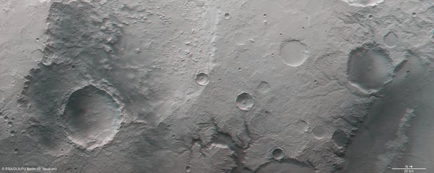
Entorno de Hebes Chasma
Este a oeste y 125 km de norte a sur en su punto más ancho. Está situada a unos 300 km al norte del gran complejo de cañones del Valles Marineris.
Los orígenes de Hebes Chasma y de los cañones que la rodean están ligados a la cercana región volcánica de Tharsis, donde se encuentra el volcán más grande del Sistema Solar, Olympus Mons.

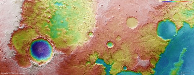
Topografía de Hebes Chasma
A medida que el abultamiento de Tharsis se iba llenando de magma durante los primeros mil millones de años de la historia de Marte, la corteza se estiraba en sus inmediaciones, llegando a fracturarse y a colapsar en gigantescas gargantas como Hebes Chasma. Alrededor de la profunda depresión se pueden distinguir intrincados patrones de fallas – visibles más claramente en la imagen principal y en las imágenes tridimensionales.
En el centro de Hebes Chasma se encuentra una ‘mesa’ plana que se eleva hasta el mismo nivel que las llanuras que rodean a la garganta. Las imágenes en perspectiva muestran esta formación desde distintos ángulos.
Este tipo de formación no se encuentra en ningún otro cañón de Marte, y sus orígenes no están del todo claros. Entre sus capas se encuentran materiales volcánicos – al igual que en las paredes del cañón principal – así como polvo arrastrado por el viento y sedimentos depositados por el agua con el paso del tiempo.
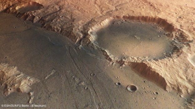
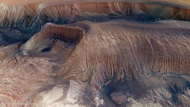
En un lado de la mesa hay una depresión con forma de herradura, como se puede observar más abajo, formada cuando el terreno se desplomó hasta el fondo de la garganta.
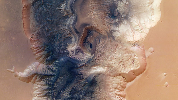
Hebes Chasma en 3D
En esta imagen también se puede distinguir una mancha oscura, que parece un charco de tinta acumulada sobre la pila de escombros, que puede ser el resultado de un corrimiento de tierras. Lo más probable es que esté formada por polvo suelto que se fue deslizando por los cauces tallados en la pared por las aguas del deshielo o de los manantiales, dándole su particular apariencia fluida. En el extremo opuesto del montículo se encuentra otra formación similar, como se puede ver en la imagen a todo color.
En el fondo de Hebes Chasma se pueden distinguir varios depósitos de escombros, muchos de ellos procedentes de las paredes del cañón principal. Las paredes de la mesa y de la garganta muestran un gran número de acanaladuras, que sugieren que están compuestas por materiales blandos y fáciles de erosionar.
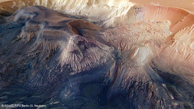
La segunda imagen en perspectiva revela una fina capa oscura rodeada por materiales más claros. Se piensa que está formada por el polvo que se deslizó desde la cima o que fue arrastrado por el viento. Alrededor de la base de la mesa también se pueden distinguir depósitos más oscuros, que pueden proceder de la erosión de los sedimentos de la cima o haber sido arrastrados por el viento o por el agua.
Las laderas de la mesa también presentan varias capas de sedimentos que pueden haber sido depositados por la acción del agua. Los datos de Mars Express y de la sonda MRO de la NASA indican que Hebes Chasma contiene minerales que sólo se forman en presencia de agua, lo que sugiere que en algún momento de su pasado este cañón pudo estar lleno de agua, formando un gran lago.
No obstante, los caóticos depósitos de escombros esparcidos por el fondo de la garganta dejan claro que
Deslizamientos y estratos en el interior de Hebes Chasma
.La segunda imagen en perspectiva revela una fina capa oscura rodeada por materiales más claros. Se piensa que está formada por el polvo que se deslizó desde la cima o que fue arrastrado por el viento. Alrededor de la base de la mesa también se pueden distinguir depósitos más oscuros, que pueden proceder de la erosión de los sedimentos de la cima o haber sido arrastrados por el viento o por el agua.
Las laderas de la mesa también presentan varias capas de sedimentos que pueden haber sido depositados por la acción del agua. Los datos de Mars Express y de la sonda MRO de la NASA indican que Hebes Chasma contiene minerales que sólo se forman en presencia de agua, lo que sugiere que en algún momento de su pasado este cañón pudo estar lleno de agua, formando un gran lago.
No obstante, los caóticos depósitos de escombros esparcidos por el fondo de la garganta dejan claro que los corrimientos de tierras jugaron un papel fundamental a la hora de ampliar esta profunda cicatriz en la corteza de Marte.

Hebes Chasma en 3D
-
-
-
- More about...


ayabaca@gmail.com
ayabaca@hotmail.com
ayabaca@yahoo.com