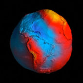
Mostrando entradas con la etiqueta GOCE (Gravity Field and Steady-State Ocean Circulation Explorer). Mostrar todas las entradas

domingo, 15 de septiembre de 2013

ESA - ESA’s GOCE mission to end this year


New GOCE geoid

Details
Open/Close
  • Title New GOCE geoid
  • Released 28/03/2011 5:31 pm
  • Copyright ESA/HPF/DLR
  • Description
    ESA's GOCE mission has delivered the most accurate model of the 'geoid' ever produced, which will be used to further our understanding of how Earth works.
    The colours in the image represent deviations in height (–100 m to +100 m) from an ideal geoid. The blue shades represent low values and the reds/yellows represent high values.
    A precise model of Earth's geoid is crucial for deriving accurate measurements of ocean circulation, sea-level change and terrestrial ice dynamics. The geoid is also used as a reference surface from which to map the topographical features on the planet. In addition, a better understanding of variations in the gravity field will lead to a deeper understanding of Earth's interior, such as the physics and dynamics associated with volcanic activity and earthquakes.

LATEST ARTICLES
  • · Andreas and Thomas testing sampl…
  • · Looking to the future of Earth o…
  • · Astronauts to meet public at EST…
  • · Teaching astronauts underground …
  • ESA’s GOCE mission to end this year

    13 September 2013
    After more than four years mapping Earth’s gravity with unrivalled precision, GOCE’s mission is nearing its end and the satellite will soon reenter our atmosphere.
    The Gravity field and steady-state Ocean Circulation Explorer – GOCE – has been orbiting Earth since March 2009 at the lowest altitude of any research satellite.
    With a sleek, aerodynamic design responsible for it being dubbed the ‘Ferrari of space’, GOCE has mapped variations in Earth’s gravity with extreme detail.
    The result is a unique model of the ‘geoid’, which is essentially a virtual surface where water does not flow from one point to another.
    In mid-October, the mission will come to a natural end when it runs out of fuel and the satellite begins its descent towards Earth from a height of about 224 km.
    While most of GOCE will disintegrate in the atmosphere, several parts might reach Earth’s surface.
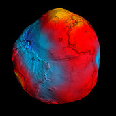
    New GOCE geoid
    GOCE geoid
    When and where these parts might land cannot yet be predicted, but the affected area will be narrowed down closer to the time of reentry. Reentry is expected to happen about three weeks after the fuel is depleted.
    Taking into account that two thirds of Earth are covered by oceans and vast areas are thinly populated, the danger to life or property is very low.
    About 40 tonnes of manmade space debris reach the ground per year, but the spread and size mean the risk of an individual being struck is lower than being hit by a meteorite.
    An international campaign is monitoring the descent, involving the Inter-Agency Space Debris Coordination Committee. The situation is being continuously watched by ESA’s Space Debris Office, which will issue reentry predictions and risk assessments.
    ESA will keep its Member States and the relevant safety authorities permanently updated.
    For media inquiries:
    ESA Media Relations Office, Communication Department
    Email: media@esa.int
    Tel: + 33 1 5369 7299
    Related articles:
    Gravity lowdown
    10 September 2013
    10 September 2013 With a catalogue of triumphs that range from delivering novel information about winds at the edge of the atmosphere to mapping the structure of Earth’s crust 200 km below our feet, ESA’s GOCE satellite is in the limelight at this week’s Living Planet...
    08 March 2013 Satellites map changes in Earth’s surface caused by earthquakes but never before have sound waves from a quake been sensed directly in space – until now. ESA’s hyper-sensitive GOCE gravity satellite has added yet another first to its list of successes.
    15 February 2013 For decades, scientists have disagreed about whether the sea is higher or lower heading north along the east coast of North America. Thanks to precision gravity data from ESA’s GOCE satellite, this controversial issue has now been settled. The answer?...

    domingo, 17 de febrero de 2013

    ESA - GOCE settles debate on sloping sea


    Sea level station
      (423.17 kB)
     The sea level station at Vaca Key in Florida. The white tube extending down to the water is an acoustic tide gauge. The hut houses the electronics while the roof contains communications equipment and solar panels. The station is also equipped with a weather station and GPS equipment.
     
    15 February 2013 For decades, scientists have disagreed about whether the sea is higher or lower heading north along the east coast of North America. Thanks to precision gravity data from ESA’s GOCE satellite, this controversial issue has now been settled. The answer? It’s lower.
    Many might assume that the height of the sea is the same everywhere – but this is not true because winds, currents, tides and different temperatures cause seawater to pile up in some regions and dip in others.
    However, it is difficult to determine relative heights of the sea, especially near the coast. To do this, tide gauge measurements need to be compared with a ‘level’ surface.
    The old method of making these calculations involved conventional levelling, carrying surveying instruments thousands of kilometres and combining measurements in the national surveying datums that were assumed to be level reference surfaces.
    Sea slope discussions
      (144.12 kB)
     The discussion between geodesists and oceanographers about whether the height of the sea increases or decreases along the east coast of North America go back to 1927 when William Bowie published Tilting of mean sea level.

    Until recently, geodesists thought that the height of the sea increased with latitude along the Atlantic coast from Florida to Canada. Their conclusions, which go back to the 1920s, were based on traditional methods that connect values of mean sea level from tide gauge measurements.
    This ran counter to the intuition of most oceanographers, who were aware of the influence that the Gulf Stream would have on the height of the sea along the coast.
    Most modern computer models of ocean circulation suggest that sea level falls travelling north, especially along the Florida coast. As this major current then sweeps away from North Carolina, coastal sea level should be essentially flat thereafter. This contrasts with the Pacific coast where there is no significant slope with latitude.
    GOCE geoid


    ESA's GOCE mission has delivered the most accurate model of the 'geoid' ever produced, which will be used to further our understanding of how Earth works.
    The colours in the image represent deviations in height (–100 m to +100 m) from an ideal geoid. The blue shades represent low values and the reds/yellows represent high values.
    A precise model of Earth's geoid is crucial for deriving accurate measurements of ocean circulation, sea-level change and terrestrial ice dynamics. The geoid is also used as a reference surface from which to map the topographical features on the planet. In addition, a better understanding of variations in the gravity field will lead to a deeper understanding of Earth's interior, such as the physics and dynamics associated with volcanic activity and earthquakes.

    GOCE maps variations in Earth’s gravity with extreme detail. The result is a unique model of the ‘geoid’, which is essentially a virtual surface where water does not flow from one point to another.
    The new geoid and in situ gravity measurements have been used as a reference to establish levelling heights. Combining the GOCE geoid and GPS heights at tide gauges provides indirect means of calculating sea heights by levelling along coastlines.
    Through ESA’s Support to Science Element programme, scientists from the National Oceanographic Centre Liverpool in the UK, the Technical University of Munich in Germany and Newcastle University in the UK have developed a new method that largely uses GOCE data to determine a reference level surface.
    Sea slope
     
     The red and blue dots show values of mean sea level (MSL) measured with respect to national datums in the US and Canada (red and blue, respectively). These data indicate that the height of the sea increases travelling north from Florida to Canada. However, most modern numerical models of ocean circulation (black dots) suggest that the slope of the sea should actually decrease travelling north and can be explained by the effects of the Gulf Stream in this region of the Atlantic Ocean. The new geoid from ESA’s GOCE gravity mission has resolved this long-debated mystery by providing conclusive proof that the height of the sea does, indeed, drop (yellow dots).

    This work complements that of Dalhousie University in Canada and other oceanographic research groups also making use of new geoid information.
    Philip Woodworth from the National Oceanographic Centre Liverpool said, “GOCE has resolved this old debate in the oceanographers’ favour.
    “The results prove conclusively that sea level decreases going north along the North American Atlantic coastline, in agreement with the ocean models.”
    Similar results agreeing with the ocean model have also been obtained along the North Pacific and European coastlines.
    GOCE in orbit

     GOCE orbit is so low that it experiences drag from the outer edges of Earth's atmosphere. The satellite's streamline structure and use of electric propulsion system counteract atmospheric drag to ensure that the data are of true gravity.

    Dru Smith from the US National Geodetic Survey said, “Since the issue was raised in 1927 studies showed a mismatch between classical and modern observations on land. The new results, however, settle the argument convincingly and are relevant for both North American coastlines. The findings are important for establishing a common height reference system between the US, Canada and Mexico.”
    Reiner Rummel from the Technical University of Munich added, “We have to admit that we geodesists were wrong and the oceanographers were right. As both geoid and ocean models continue to improve, we can expect to learn many more interesting details about sea level and ocean circulation.
    “Importantly, data from GOCE will lead to a unified global height system so that we can consistently study sea-level change apparent in tide gauge and satellite altimetry data.”
    RELATED ARTICLES:
    ESA
    Guillermo Gonzalo Sánchez Achutegui
    ayabaca@gmail.com
    ayabaca@hotmail.com
    ayabaca@yahoo.com

    domingo, 18 de noviembre de 2012

    ESA Portal - GOCE’s second mission improving gravity map


    http://www.esa.int/images/PerformanceImprovements_H.jpg

    Download:
    The image on the left shows GOCE’s gravity measurements over northern Europe, acquired from its previous altitude. The image on the right depicts the expected measurements over the same area after the satellite has been lowered by 15 km. An increased signal and improved spatial resolution is evident. 
    Credits: ESA / GOCE+ Theme 2
    Download:
     The need for GOCE (Gravity Field and Steady-State Ocean Circulation Explorer) to fly in a low orbit means it has to be equipped with a system to compensate for the atmospheric drag it will experience at this exceptionally low altitude. The animation shows a close-up of the ion-propulsion assembly, which keeps the satellite in a smooth trajectory – free from all effects except the gravity field itself. Two winglets provide additional aerodynamic stability. 
    Credits: ESA/AOES Medialab
    ESA’s GOCE gravity satellite has already delivered the most accurate gravity map of Earth, but its orbit is now being lowered in order to obtain even better results.

    The Gravity field and steady-state Ocean Circulation Explorer (GOCE) has been orbiting Earth since March 2009, reaching its ambitious objective to map our planet’s gravity with unrivalled precision.
    Although the planned mission has been completed, the fuel consumption was much lower than anticipated because of the low solar activity over the last two years. This has enabled ESA to extend GOCE’s life, improving the quality of the gravity model.
    To be able to measure the strength of Earth’s gravity, the satellite was flying in an extraordinarily low orbit about 255 km high – about 500 km lower than most Earth observation satellites.
    Based on a clear preference from the GOCE user community, ESA’s Earth Scientific Advisory Committee recommended lowering the orbit to 235 km starting in August. 
    Lowering the orbit increases the accuracy and resolution of GOCE’s measurements, improving our view of smaller ocean dynamics such as eddy currents. The control team began the manoeuvres in August, lowering GOCE by about 300 m per day.
    After coming down by 8.6 km, the satellite’s performance and new environment were assessed. Now, GOCE is again being lowered while continuing its gravity mapping. Finally, it is expected to reach 235 km in February.
    As the orbit drops, atmospheric drag increasingly pulls the satellite towards Earth. But GOCE was designed to fly low, the tiny thrust of its ion engine continuously compensating for any drag.
    The expected increase in data quality is so high that scientists are calling it GOCE’s ‘second mission.’
    Download:
     HI-RES JPEG (Size: 6044 kb
     ESA's GOCE mission has delivered the most accurate model of the 'geoid' ever produced, which will be used to further our understanding of how Earth works.
    The colours in the image represent deviations in height (–100 m to +100 m) from an ideal geoid. The blue colours represent low values and the reds/yellows represent high values.
    A precise model of Earth's geoid is crucial for deriving accurate measurements of ocean circulation, sea-level change and terrestrial ice dynamics. The geoid is also used as a reference surface from which to map the topographical features on the planet. In addition, a better understanding of variations in the gravity field will lead to a deeper understanding of Earth's interior, such as the physics and dynamics associated with volcanic activity and earthquakes. 
    Credits: ESA/HPF/DLR

    “For us at ESA, GOCE has been a fantastic mission and it continues to surprise us,” said Volker Liebig, ESA’s Director of Earth Observation Programmes.
    “What the team of ESA engineers is now doing has not been done before and it poses a challenge. But it will also trigger new research in the field of gravity based on the high-resolution data we are expecting.”
    The first ‘geoid’ based on GOCE’s gravity measurements was unveiled in June 2010. It is the surface of an ideal global ocean in the absence of tides and currents, shaped only by gravity.
    A geoid is a crucial reference for conducting precise measurements of ocean circulation, sea-level change and ice dynamics.
    The mission has also been providing new insight into air density and wind in space, and its information was recently used to produce the first global high-resolution map of the boundary between Earth’s crust and mantle.
      ESA
    Guillermo Gonzalo Sánchez Achutegui
    ayabaca@hotmail.com
    ayabaca@gmail.com
    ayabaca@yahoo.com