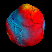
New GOCE geoid

Details
- Title New GOCE geoid
- Released 28/03/2011 5:31 pm
- Copyright ESA/HPF/DLR
- DescriptionESA's GOCE mission has delivered the most accurate model of the 'geoid' ever produced, which will be used to further our understanding of how Earth works.The colours in the image represent deviations in height (–100 m to +100 m) from an ideal geoid. The blue shades represent low values and the reds/yellows represent high values.A precise model of Earth's geoid is crucial for deriving accurate measurements of ocean circulation, sea-level change and terrestrial ice dynamics. The geoid is also used as a reference surface from which to map the topographical features on the planet. In addition, a better understanding of variations in the gravity field will lead to a deeper understanding of Earth's interior, such as the physics and dynamics associated with volcanic activity and earthquakes.
LATEST ARTICLES
- MOST-VIEWED ARTICLES
- · New images from Titan
- · Black hole-star pair orbiting…
- · Planck reveals an almost perf…
- · How many stars are there in t…
- · Reull Vallis: a river ran thr…
- MOST-VIEWED IMAGES
- · Planck CMB
- · Titan’s Nile River
- · Mapping Mars
- · Reull Vallis
- · Perspective view of Reull Val…
ESA’s GOCE mission to end this year
13 September 2013
After more than four years mapping Earth’s gravity with unrivalled precision, GOCE’s mission is nearing its end and the satellite will soon reenter our atmosphere.
The Gravity field and steady-state Ocean Circulation Explorer – GOCE – has been orbiting Earth since March 2009 at the lowest altitude of any research satellite.
With a sleek, aerodynamic design responsible for it being dubbed the ‘Ferrari of space’, GOCE has mapped variations in Earth’s gravity with extreme detail.
The result is a unique model of the ‘geoid’, which is essentially a virtual surface where water does not flow from one point to another.
In mid-October, the mission will come to a natural end when it runs out of fuel and the satellite begins its descent towards Earth from a height of about 224 km.
While most of GOCE will disintegrate in the atmosphere, several parts might reach Earth’s surface.
When and where these parts might land cannot yet be predicted, but the affected area will be narrowed down closer to the time of reentry. Reentry is expected to happen about three weeks after the fuel is depleted.
Taking into account that two thirds of Earth are covered by oceans and vast areas are thinly populated, the danger to life or property is very low.
About 40 tonnes of manmade space debris reach the ground per year, but the spread and size mean the risk of an individual being struck is lower than being hit by a meteorite.
An international campaign is monitoring the descent, involving the Inter-Agency Space Debris Coordination Committee. The situation is being continuously watched by ESA’s Space Debris Office, which will issue reentry predictions and risk assessments.
ESA will keep its Member States and the relevant safety authorities permanently updated.
For media inquiries:
Related articles:


10 September 2013 With a catalogue of triumphs that range from delivering novel information about winds at the edge of the atmosphere to mapping the structure of Earth’s crust 200 km below our feet, ESA’s GOCE satellite is in the limelight at this week’s Living Planet...


08 March 2013 Satellites map changes in Earth’s surface caused by earthquakes but never before have sound waves from a quake been sensed directly in space – until now. ESA’s hyper-sensitive GOCE gravity satellite has added yet another first to its list of successes.

GOCE settles debate on sloping sea15 February 2013

15 February 2013 For decades, scientists have disagreed about whether the sea is higher or lower heading north along the east coast of North America. Thanks to precision gravity data from ESA’s GOCE satellite, this controversial issue has now been settled. The answer?...
ESA
Guillermo Gonzalo Sánchez Achutegui
ayabaca@hotmail.com


No hay comentarios:
Publicar un comentario