domingo, 2 de junio de 2013

NASA - NASA's Grail Mission Solves Mystery of Moon's Surface Gravity


GRAIL artist's rendition 
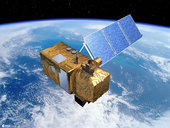
Using a precision formation-flying technique, the twin GRAIL spacecraft mapped the moon's gravity field, as depicted in this artist's rendering. detail. Image credit: NASA/JPL-Caltech
› Full image and caption
  PASADENA, Calif. -- NASA's Gravity Recovery and Interior Laboratory (GRAIL) mission has uncovered the origin of massive invisible regions that make the moon's gravity uneven, a phenomenon that affects the operations of lunar-orbiting spacecraft.
Because of GRAIL's findings, spacecraft on missions to other celestial bodies can navigate with greater precision in the future.
GRAIL's twin spacecraft studied the internal structure and composition of the moon in unprecedented detail for nine months. They pinpointed the locations of large, dense regions called mass concentrations, or mascons, which are characterized by strong gravitational pull. Mascons lurk beneath the lunar surface and cannot be seen by normal optical cameras.
GRAIL scientists found the mascons by combining the gravity data from GRAIL with sophisticated computer models of large asteroid impacts and known detail about the geologic evolution of the impact craters. The findings are published in the May 30 edition of the journal Science.
"GRAIL data confirm that lunar mascons were generated when large asteroids or comets impacted the ancient moon, when its interior was much hotter than it is now," said Jay Melosh, a GRAIL co-investigator at Purdue University in West Lafayette, Ind., and lead author of the paper. "We believe the data from GRAIL show how the moon's light crust and dense mantle combined with the shock of a large impact to create the distinctive pattern of density anomalies that we recognize as mascons."
The origin of lunar mascons has been a mystery in planetary science since their discovery in 1968 by a team at NASA's Jet Propulsion Laboratory in Pasadena, Calif. Researchers generally agree mascons resulted from ancient impacts billions of years ago. It was not clear until now how much of the unseen excess mass resulted from lava filling the crater or iron-rich mantle upwelling to the crust.
On a map of the moon's gravity field, a mascon appears in a target pattern. The bulls-eye has a gravity surplus. It is surrounded by a ring with a gravity deficit. A ring with a gravity surplus surrounds the bulls-eye and the inner ring. This pattern arises as a natural consequence of crater excavation, collapse and cooling following an impact. The increase in density and gravitational pull at a mascon's bulls-eye is caused by lunar material melted from the heat of a long-ago asteroid impact.
"Knowing about mascons means we finally are beginning to understand the geologic consequences of large impacts," Melosh said. "Our planet suffered similar impacts in its distant past, and understanding mascons may teach us more about the ancient Earth, perhaps about how plate tectonics got started and what created the first ore deposits."
This new understanding of lunar mascons also is expected to influence knowledge of planetary geology well beyond that of Earth and our nearest celestial neighbor.
"Mascons also have been identified in association with impact basins on Mars and Mercury," said GRAIL principal investigator Maria Zuber of the Massachusetts Institute of Technology in Cambridge. "Understanding them on the moon tells us how the largest impacts modified early planetary crusts."
Launched as GRAIL A and GRAIL B in September 2011, the probes, renamed Ebb and Flow, operated in a nearly circular orbit near the poles of the moon at an altitude of about 34 miles (55 kilometers) until their mission ended in December 2012. The distance between the twin probes changed slightly as they flew over areas of greater and lesser gravity caused by visible features, such as mountains and craters, and by masses hidden beneath the lunar surface.
JPL, a division of the California Institute of Technology in Pasadena, Calif. managed GRAIL for NASA's Science Mission Directorate in Washington. The mission was part of the Discovery Program managed at NASA's Marshall Space Flight Center in Huntsville, Ala. NASA's Goddard Space Flight Center, in Greenbelt, Md., manages the Lunar Reconnaissance Orbiter. Operations of the spacecraft's laser altimeter, which provided supporting data used in this investigation, is led by the Massachusetts Institute of Technology in Cambridge. Lockheed Martin Space Systems in Denver built GRAIL.
For more information about GRAIL,
 visit
 http://www.nasa.gov/grail
and
 http://grail.nasa.gov .
 
 
DC Agle 818-393-9011
Jet Propulsion Laboratory, Pasadena, Calif.
agle@jpl.nasa.gov

Dwayne Brown 202-358-1726
Headquarters, Washington
dwayne.c.brown@nasa.gov

Elizabeth Gardner 765-494-2081
Purdue University, West Lafayette, Ind.
ekgardner@purdue.edu

Jennifer Chu 617-715-4531
Massachusetts Institute of Technology, Cambridge, Mass.
j_chu@mit.edu
NASA
 Guillermo Gonzalo Sánchez Achutegui
ayabaca@gmail.com
ayabaca@hotmail.com
ayabaca@yahoo.com

NASA - Radiation Measured by NASA's Curiosity on Voyage to Mars has Implications for Future Human Missions


Cruise Vehicles (Artist Concept) 
This set of artist's concepts shows NASA's Mars Science Laboratory cruise capsule and NASA's Orion spacecraft, which is being built now at NASA's Johnson Space Center and will one day send astronauts to Mars. Image credit: NASA/JPL-Caltech/JSC
› Full image and caption

This graphic compares the radiation dose equivalent for several types of experiences 
This graphic compares the radiation dose equivalent for several types of experiences, including a calculation for a trip from Earth to Mars based on measurements made by the Radiation Assessment Detector instrument shielded inside NASA's Mars Science Laboratory spacecraft during the flight from Earth to Mars in 2011 and 2012. Image credit: NASA/JPL-Caltech/SwRI
› Full image and caption
› Image gallery

Radiation Assessment Detector for Mars Science Laboratory 
This instrument, shown prior to its September 2010 installation onto NASA's Mars rover Curiosity, will aid future human missions to Mars by providing information about the radiation environment on Mars and on the way to Mars. Image credit: NASA/JPL-Caltech/SwRI
› Full image and caption

This illustration depicts the two main types of radiation that RAD monitors, and how the magnetic field around Earth affects the radiation in space near Earth 
The Radiation Assessment Detector (RAD) on NASA's Curiosity Mars rover monitors high-energy atomic and subatomic particles coming from the sun, distant supernovae and other sources. Image credit: NASA/JPL-Caltech/SwRI
› Full image and caption

WASHINGTON -- Measurements taken by NASA's Mars Science Laboratory (MSL) mission as it delivered the Curiosity rover to Mars in 2012 are providing NASA the information it needs to design systems to protect human explorers from radiation exposure on deep-space expeditions in the future.

MSL's Radiation Assessment Detector (RAD) is the first instrument to measure the radiation environment during a Mars cruise mission from inside a spacecraft that is similar to potential human exploration spacecraft. The findings will reduce uncertainty about the effectiveness of radiation shielding and provide vital information to space mission designers who will need to build in protection for spacecraft occupants in the future.

"As this nation strives to reach an asteroid and Mars in our lifetimes, we're working to solve every puzzle nature poses to keep astronauts safe so they can explore the unknown and return home," said William Gerstenmaier, NASA's associate administrator for human exploration and operations in Washington. "We learn more about the human body's ability to adapt to space every day aboard the International Space Station. As we build the Orion spacecraft and Space Launch System rocket to carry and shelter us in deep space, we'll continue to make the advances we need in life sciences to reduce risks for our explorers. Curiosity's RAD instrument is giving us critical data we need so that we humans, like the rover, can dare mighty things to reach the Red Planet."

The findings, which are published in the May 31 edition of the journal Science, indicate radiation exposure for human explorers could exceed NASA's career limit for astronauts if current propulsion systems are used.

Two forms of radiation pose potential health risks to astronauts in deep space. One is galactic cosmic rays (GCRs), particles caused by supernova explosions and other high-energy events outside the solar system. The other is solar energetic particles (SEPs) associated with solar flares and coronal mass ejections from the sun.

Radiation exposure is measured in units of Sievert (Sv) or milliSievert (one one-thousandth Sv). Long-term population studies have shown exposure to radiation increases a person's lifetime cancer risk. Exposure to a dose of 1 Sv, accumulated over time, is associated with a 5 percent increase in risk for developing fatal cancer.

NASA has established a 3 percent increased risk of fatal cancer as an acceptable career limit for its astronauts currently operating in low-Earth orbit. The RAD data showed the Curiosity rover was exposed to an average of 1.8 milliSieverts of GCR per day on its journey to Mars. Only about 5 percent of the radiation dose was associated with solar particles because of a relatively quiet solar cycle and the shielding provided by the spacecraft.

The RAD data will help inform current discussions in the United States medical community, which is working to establish exposure limits for deep-space explorers in the future.

"In terms of accumulated dose, it's like getting a whole-body CT scan once every five or six days," said Cary Zeitlin, a principal scientist at the Southwest Research Institute (SwRI) in San Antonio and lead author of the paper on the findings. "Understanding the radiation environment inside a spacecraft carrying humans to Mars or other deep space destinations is critical for planning future crewed missions."

Current spacecraft shield much more effectively against SEPs than GCRs. To protect against the comparatively low energy of typical SEPs, astronauts might need to move into havens with extra shielding on a spacecraft or on the Martian surface, or employ other countermeasures. GCRs tend to be highly energetic, highly penetrating particles that are not stopped by the modest shielding provided by a typical spacecraft.

"Scientists need to validate theories and models with actual measurements, which RAD is now providing," said Donald M. Hassler, a program director at SwRI and principal investigator of the RAD investigation. "These measurements will be used to better understand how radiation travels through deep space and how it is affected and changed by the spacecraft structure itself. The spacecraft protects somewhat against lower energy particles, but others can propagate through the structure unchanged or break down into secondary particles."

After Curiosity landed on Mars in August, the RAD instrument continued operating, measuring the radiation environment on the planet's surface. RAD data collected during Curiosity's science mission will continue to inform plans to protect astronauts as NASA designs future missions to Mars in the coming decades.

SwRI, together with Christian Albrechts University in Kiel, Germany, built RAD with funding from NASA's Human Exploration and Operations Mission Directorate and Germany's national aerospace research center, Deutsches Zentrum fur Luft- und Raumfahrt.

NASA's Jet Propulsion Laboratory, a division of the California Institute of Technology in Pasadena, Calif., manages the Mars Science Laboratory Project. The NASA Science Mission Directorate at NASA Headquarters in Washington manages the Mars Exploration Program.

For more information about the findings and the Mars Science Laboratory mission, visit:


For more information about NASA human spaceflight and exploration, visit:
 
NASA
Guillermo Gonzalo Sánchez Achutegui
ayabaca@gmail.com
ayabaca@hotmail.com
ayabaca@yahoo.com

ESA - Copernicus Masters wants your ideas


Copernicus Masters wants you ideas
Submit your ideas to this year’s competition on how Earth observation data can benefit business and society. Entries will be accepted in all nine categories starting tomorrow.
The Copernicus Masters – previously known as the GMES Masters – rewards the best ideas for services, business cases and applications based on satellite Earth observation data. With a prize pool of € 350 000 in cash prizes, technical support, data packages and business incubation, it aims to foster product development and entrepreneurship in Europe.
Started in 2011 by ESA, the Bavarian Ministry of Economic Affairs, the DLR German Aerospace Center, Anwendungszentrum Oberpfaffenhofen and T-Systems GmbH, the competition is supported by the European Commission, European Space Imaging GmbH, Astrium GEO-Information Services, BMW Group and GEO magazine.
Participants in the competition can choose from a total of nine Challenges covering topics such as environmental monitoring, cloud computing and mobile services, as well as the innovative use of radar and very high-resolution satellite imagery.
The ESA App Challenge will award the best application idea that uses Earth observation data from European missions on mobile phones.
A €10 000 cash prize will be awarded to the winner of this category, along with the chance to have the idea further developed in one of the seven ESA Business Incubation Centres, valued at €60 000.
Last year’s winning team from the Norwegian company AnsuR Technologies AS won the prize with the ASIGN app. It uses crowdsourcing to support personnel deployed in disaster areas by encouraging users to take pictures of the situation on the ground. These images then supplement remote satellite data.
ASIGN was used to aid relief efforts during the 2011 floods in Thailand.
Sentinel-2
Other categories in the Copernicus Masters competition include the Best Service Challenge, which aims to increase awareness of existing Earth monitoring services and their benefits, and the Ideas Challenge for the innovative commercial use of Copernicus data.
The European Space Imaging High-Res Challenge invites people to create new and viable applications using very high-resolution satellite data.
Contestants in the GEO Illustration Challenge are asked to illustrate humankind’s footprint on our planet – from past to current developments – in vivid, artistic ways based on satellite imagery. ESA is teaming up with DLR, European Space Imaging and Astrium GEO-Information Services to provide free satellite data to the contestants of this category.
Submissions for the GEO Illustration Challenge ‘Traces of Humankind’ are being accepted until 30 June. All other challenges are open from 1 June to 15 September.
For a complete list of Challenges and more information on the competition, visit the Copernicus Masters website.
‘Copernicus’ is the new name for the Global Monitoring for Environment and Security (GMES) programme.


ESA
Guillermo Gonzalo Sánchez Achutegui
ayabaca@gmail.com
ayabaca@hotmail.com
ayabaca@yahoo.com

ESA - Image of the week: Crete


EARTH FROM SPACE: CRETE
31 May 2013
This image shows northwestern Crete, the largest and most populous of the Greek islands, some 250 km long and 40 km wide.
Crete, which separates the Aegean and Libyan Seas in the eastern Mediterranean, is home to numerous beaches, fertile plateaus, caves and high mountains.
The island’s economy is predominantly based on agriculture, with significant vineyards, olive groves and citrus crops. Dairy is also very important, with a variety of sheep and goat cheeses available.
In the lower-right, the bright cluster of radar reflections on the northern coast is the city of Chania, the island’s second largest city after Heraklion (not pictured).
At the centre of the image is the Rodopou Peninsula. It is about 8 km long and 5 km wide. While the southern part of the peninsula is dotted with small villages, the northern part is practically uninhabited barring the shepherds.
Off the coast of the other peninsula to the left there are two small islands: Imeri Gramvousa to the south and Agria Gramvousa due north. Both are uninhabited, but the southern island hosts ruins of a Venetian fort and structures of Cretan insurgents in the 1820s – who resorted to piracy to survive.
This image is a compilation of three radar images from Japan’s ALOS satellite acquired on 28 August 2010, 13 October 2010 and the third band created by combining the other two.
This image is featured on the Earth from Space video programme.
ESA
Guillermo Gonzalo Sánchez Achutegui
ayabaca@gmail.com
ayabaca@hotamil.com
ayabaca@yahoo.com

NASA - NASA's WISE Mission Finds Lost Asteroid Family Members


This artist's conception shows how families of asteroids are created
This artist's conception shows how families of asteroids are created. Over the history of our solar system, catastrophic collisions between asteroids located in the belt between Mars and Jupiter have formed families of objects on similar orbits around the sun. Image credit: NASA/JPL-Caltech 

WASHINGTON -- Data from NASA's Wide-field Infrared Survey Explorer (WISE) have led to a new and improved family tree for asteroids in the main belt between Mars and Jupiter.

Astronomers used millions of infrared snapshots from the asteroid-hunting portion of the WISE all-sky survey, called NEOWISE, to identify 28 new asteroid families. The snapshots also helped place thousands of previously hidden and uncategorized asteroids into families for the first time. The findings are a critical step in understanding the origins of asteroid families, and the collisions thought to have created these rocky clans.

"NEOWISE has given us the data for a much more detailed look at the evolution of asteroids throughout the solar system," said Lindley Johnson, the program executive for the Near-Earth Object Observation Program at NASA Headquarters in Washington. "This will help us trace the NEOs back to their sources and understand how some of them have migrated to orbits hazardous to the Earth."

The main asteroid belt is a major source of near-Earth objects (NEOs), which are those asteroids and comets that come within 28 million miles (45 million kilometers) of Earth's path around the sun. Some near-Earth objects start out in stable orbits in the main asteroid belt, until a collision or gravitational disturbance flings them inward like flippers in a game of pinball.

The NEOWISE team looked at about 120,000 main belt asteroids out of the approximately 600,000 known. They found that about 38,000 of these objects, roughly one third of the observed population, could be assigned to 76 families, 28 of which are new. In addition, some asteroids thought to belong to a particular family were reclassified.

An asteroid family is formed when a collision breaks apart a large parent body into fragments of various sizes. Some collisions leave giant craters. For example, the asteroid Vesta's southern hemisphere was excavated by two large impacts. Other smash-ups are catastrophic, shattering an object into numerous fragments, as was the case with the Eos asteroid family. The cast-off pieces move together in packs, traveling on the same path around the sun, but over time the pieces become more and more spread out.

Previous knowledge of asteroid family lineages comes from observations of their orbits. NEOWISE also looked at the asteroids' reflectivity to identify family members.

Asteroids in the same family generally have similar mineral composition and reflect similar amounts of light. Some families consist of darker-colored, or duller, asteroids, while others are made up of lighter-colored, or shinier, rocks. It is difficult to distinguish between dark and light asteroids in visible light. A large, dull asteroid can appear the same as a small, shiny one. The dark asteroid reflects less light but has more total surface area, so it appears brighter.

NEOWISE could distinguish between the dark and light asteroids because it can detect infrared light, which reveals the heat of an object. The larger the object, the more heat it gives off. When the size of an asteroid can be measured, its true reflective properties can be determined, and a group of asteroids once thought to belong to a single family circling the sun in a similar orbit can be sorted into distinct families.

"We're separating zebras from the gazelles," said Joseph Masiero of NASA's Jet Propulsion Laboratory (JPL) in Pasadena, Calif., who is lead author of a report on the new study that appears in the Astrophysical Journal. "Before, family members were harder to tell apart because they were traveling in nearby packs. But now we have a better idea of which asteroid belongs to which family."

The next step for the team is to learn more about the original parent bodies that spawned the families.

"It's as if you have shards from a broken vase, and you want to put it back together to find out what happened," said Amy Mainzer, the NEOWISE principal investigator at JPL. "Why did the asteroid belt form in the first place and fail to become a planet? We are piecing together our asteroids' history."

JPL, a division of the California of Technology in Pasadena, managed and operated WISE for NASA's Science Mission Directorate. The spacecraft was put into hibernation mode in 2011, after completing its main objectives of scanning the entire sky twice.

More information is online at:

NASA
Guillermo Gonzalo Sánchez Achutegui
ayabaca@gmail.com
ayabaca@hotmail.com
ayabaca@yahoo.com

NASA - NASA'S Swift Reveals New Phenomenon in a Neutron Star

Astronomers using NASA's Swift X-ray Telescope have observed a spinning neutron star suddenly slowing down, yielding clues they can use to understand these extremely dense objects.

A neutron star is the crushed core of a massive star that ran out of fuel, collapsed under its own weight, and exploded as a supernova. A neutron star can spin as fast as 43,000 times per minute and boast a magnetic field a trillion times stronger than Earth's. Matter within a neutron star is so dense a teaspoonful would weigh about a billion tons on Earth.

artist's rendering of an outburst on an ultra-magnetic neutron star, also called a magnetar
An artist's rendering of an outburst on an ultra-magnetic neutron star, also called a magnetar.
Credit: NASA's Goddard Space Flight Center
› Larger image
› Download additional graphics from NASA Goddard's Scientific Visualization Studio

This neutron star, 1E 2259+586, is located about 10,000 light-years away toward  the constellation Cassiopeia . It is one of about two dozen neutron stars called magnetars, which have very powerful magnetic fields and occasionally produce high-energy explosions or pulses.

Observations of X-ray pulses from 1E 2259+586 from July 2011 through mid-April 2012 indicated the magnetar's rotation was gradually slowing from once every seven seconds, or about eight revolutions per minute. On April 28, 2012, data showed the spin rate had decreased abruptly, by 2.2 millionths of a second, and the magnetar was spinning down at a faster rate.

false-color X-ray image of the CTB 109 supernova remnant
The magnetar 1E 2259+586 shines a brilliant blue-white in this false-color X-ray image of the CTB 109 supernova remnant, which lies about 10,000 light-years away toward the constellation Cassiopeia. CTB 109 is only one of three supernova remnants in our galaxy known to harbor a magnetar. X-rays at low, medium and high energies are respectively shown in red, green, and blue in this image created from observations acquired by the European Space Agency's XMM-Newton satellite in 2002.
Credit: ESA/XMM-Newton/M. Sasaki et al.
› Larger image
› Download additional graphics from NASA Goddard's Scientific Visualization Studio

"Astronomers have witnessed hundreds of events, called glitches, associated with sudden increases in the spin of neutron stars, but this sudden spin-down caught us off guard," said Victoria Kaspi, a professor of physics at McGill University in Montreal. She leads a team that uses Swift to monitor magnetars routinely.

Astronomers dubbed the event an "anti-glitch," said co-author Neil Gehrels, principal investigator of the Swift mission at NASA's Goddard Space Flight Center in Greenbelt, Md. "It affected the magnetar in exactly the opposite manner of every other clearly identified glitch seen in neutron stars."

The discovery has important implications for understanding the extreme physical conditions present within neutron stars, where matter becomes squeezed to densities several times greater than an atomic nucleus. No laboratory on Earth can duplicate these conditions.

A report on the findings appears in the May 30 edition of the journal Nature.

artist concept of neutron star compared to satellite image of Manhattan for scale
A neutron star is the densest object astronomers can observe directly, crushing half a million times Earth's mass into a sphere about 12 miles across, or similar in size to Manhattan Island, as shown in this illustration.
Credit: NASA's Goddard Space Flight Center
› Larger image
› Download additional graphics from NASA Goddard's Scientific Visualization Studio

The internal structure of neutron stars is a long-standing puzzle. Current theory maintains a neutron star has a crust made up of electrons and ions; an interior containing oddities that include a neutron superfluid, which is a bizarre state of matter without friction; and a surface that accelerates streams of high-energy particles through the star's intense magnetic field.

The streaming particles drain energy from the crust. The crust spins down, but the fluid interior resists being slowed. The crust fractures under the strain. When this happens, a glitch occurs. There is an X-ray outburst and the star gets a speedup kick from the faster-spinning interior.

Processes that lead to a sudden rotational slowdown constitute a new theoretical challenge.

On April 21, 2012, just a week before Swift observed the anti-glitch, 1E 2259+586 produced a brief, but intense X-ray burst detected by the Gamma-ray Burst Monitor aboard NASA's Fermi Gamma-ray Space Telescope. The scientists think this 36-millisecond eruption of high-energy light likely signaled the changes that drove the magnetar's slowdown.

"What is really remarkable about this event is the combination of the magnetar's abrupt slowdown, the X-ray outburst, and the fact we now observe the star spinning down at a faster rate than before," said lead author Robert Archibald, a graduate student at McGill.

Goddard manages Swift, which was launched in November 2004. The telescope is operated in collaboration with Pennsylvania State University in University Park, Pa., the Los Alamos National Laboratory in New Mexico and Orbital Sciences Corp. in Dulles, Va. International collaborators are in the United Kingdom and Italy, and the mission includes contributions from Germany and Japan.

Related Links


Francis Reddy
NASA's Goddard Space Flight Center, Greenbelt, Md.
NASA
Guillermo Gonzalo Sánchez Achutegui
ayabaca@gmail.com
ayabaca@hotmail.com
ayabaca@yahoo.com

nsf.gov - News - Expedition to the Gulf of Alaska: Scientists Study Coastal Mountains and Glaciers

Researchers follow path of sediments from mountains and glaciers to the deep sea.-

Alaska's Malaspina Glacier
Alaska's Malaspina Glacier, visible in the foreground, spreads over the land as it 'flows.'
Credit: John Jaeger
Download the high-resolution JPG version of the image. (4.7 MB)

The scientific drilling vessel JOIDES Resolution
The scientific drilling vessel JOIDES Resolution is on an expedition in the Gulf of Alaska.
Credit: IODP
Download the high-resolution JPG version of the image. (464 KB)

Map of the Gulf of Alaska, where IODP Expedition 341 is taking place.
Credit: Wikimedia Commons
Download the high-resolution PNG version of the image. (282 KB)
Mpa showing sites marked in red show where scientists plan to retrieve sediment core samples.
Sites marked in red show where scientists plan to retrieve sediment core samples.
Credit: IODP
Download the high-resolution JPG version of the image. (168 KB)
Malaspina Glacier as seen from space
Malaspina Glacier (from space) is a piedmont glacier: it's along the foot of a mountain range.
Credit: NASA
Download the high-resolution JPG version of the image. (176 KB)
Location of current drilling sites on IODP Expedition 341, and previous drilling sites (inset).
Credit: IODP
Download the high-resolution JPG version of the image. (420 KB)
Geologists aboard the scientific ocean drilling vessel JOIDES Resolution have embarked on their next adventure: studying glaciers to learn how Earth's geologic processes relate to the planet's climate history.
In the waters near Alaska's stunning coastal glaciers, the researchers are on Integrated Ocean Drilling Program (IODP) Expedition 341: Southern Alaska Margin Tectonics, Climate and Sedimentation.
The ship set sail today from Victoria, British Columbia. The expedition will conclude on July 29, 2013.
"Its scientists are examining the relationship between mountain-building, glaciation and climate," says Jamie Allan, program director in the U.S. National Science Foundation's (NSF) Division of Ocean Sciences, which supports IODP.
"This interplay happens not only in Alaska but in other parts of the world," says Allan. "New insights into these processes will help scientists better understand climate history and change, and how mountain landscapes form."
Led by co-chief scientists John Jaeger of the University of Florida and Sean Gulick of the University of Texas at Austin, an international team of researchers will collect and study sediments from five locations in the Gulf of Alaska.
They will investigate interactions between long-term climate change, including the fluctuations of large glaciers, and how mountains form.
The geologists will also conduct research on the transport of sediments from the mountains to the deep sea.
Because glaciers can erode and carry with them large amounts of rock, these rivers of ice can dramatically alter the landscape.
By rapidly decreasing the overall amount of rock in areas they scour, glaciers can also alter mountain ranges and cause uplifting--sometimes in less than one million years. In geologic terms, a relatively short time span.
"Mountains grow when numerous faults thrust layers of rock on top of each other," Gulick says. "We're asking whether this increases in locations with lots of erosion, such as beneath Alaska's glaciers."
The mountains of southern Alaska "have the perfect combination of large glaciers and rapidly uplifting mountains to test this idea," says Jaeger.
"We know very little about the long-term history of these glaciers," he says, "relative to what we know about other large ice sheets in, for example, Greenland and Antarctica."
The scientists are also comparing the advance and retreat of the Northern Cordilleran Ice Sheet with those of other major ice sheets. During the last 2.6 or so million years, the Cordilleran Ice Sheet periodically covered a large part of North America.
They also plan to obtain a record of Earth's magnetic field reversals recorded in the Gulf of Alaska, and look at ocean circulation changes and their effects on Earth's carbon cycle during transitions into and out of ice ages.
"Thousands of tourists sail through the Gulf of Alaska each year to see the dramatic landscapes created by these glaciers," Jaeger says.
Jaeger hopes that, in addition to many scientific benefits, "the findings from this expedition will provide tourists with a sense of how dynamic that landscape truly is."
The Integrated Ocean Drilling Program (IODP) is an international research program dedicated to advancing scientific understanding of the Earth through drilling, coring and monitoring the subseafloor.
The JOIDES Resolution is a scientific research vessel managed by the U.S. Implementing Organization of IODP (USIO). Texas A&M University, Lamont-Doherty Earth Observatory of Columbia University and the Consortium for Ocean Leadership comprise the USIO.
IODP is supported by two lead agencies: the U.S. National Science Foundation and Japan's Ministry of Education, Culture, Sports, Science and Technology.
Additional program support comes from the European Consortium for Ocean Research Drilling, the Australia-New Zealand IODP Consortium, India's Ministry of Earth Sciences, the People's Republic of China's Ministry of Science and Technology, the Korea Institute of Geoscience and Mineral Resources and Brazil's Ministry of Education.
-NSF-
Media Contacts Cheryl Dybas, NSF (703) 292-7734 cdybas@nsf.gov
Matt Wright, Consortium for Ocean Leadership (202) 448-1254 mwright@oceanleadership.org
Miyuki Otomo, IODP (+81) 367013188 motomo@iodp.org
Related WebsitesIODP Expedition 341: Southern Alaska Margin Tectonics, Climate and Sedimentation: http://iodp.tamu.edu/scienceops/expeditions/alaska_tectonics_climate.html
The National Science Foundation (NSF) is an independent federal agency that supports fundamental research and education across all fields of science and engineering. In fiscal year (FY) 2012, its budget was $7.0 billion. NSF funds reach all 50 states through grants to nearly 2,000 colleges, universities and other institutions. Each year, NSF receives about 50,000 competitive requests for funding, and makes about 11,500 new funding awards. NSF also awards about $593 million in professional and service contracts yearly.
Useful NSF Web Sites:
NSF Home Page: http://www.nsf.gov
NSF News: http://www.nsf.gov/news/
For the News Media: http://www.nsf.gov/news/newsroom.jsp
Science and Engineering Statistics: http://www.nsf.gov/statistics/
Awards Searches: http://www.nsf.gov/awardsearch/
The National Science Foundation (NSF)
 Guillermo Gonzalo Sánchez Achutegui
ayabaca@gmail.com
ayabaca@hotmail.com
ayabaca@yahoo.com