Hola amigos: A VUELO DE UN QUINDE EL BLOG., la Fundación Nacional de Ciencia de Los Estados Unidos, nos informa sobre las investigaciones que se están contra el Virus del Ébola en Nigeria...."Ebola. La palabra trae temor a un enemigo invisible y potencialmente letal. Pero hay formas de detener su propagación, dicen los científicos en enfermedades infecciosas.
Se requiere una intervención rápida, de acuerdo con los investigadores, quienes recientemente publicaron sus hallazgos en la revista Eurosurveillance.
Se requiere una intervención rápida, de acuerdo con los investigadores, quienes recientemente publicaron sus hallazgos en la revista Eurosurveillance.
Analizar casos de Ébola en Nigeria, un país con éxito en la contención de la enfermedad, los científicos estima que la tasa de mortalidad, la progresión de la transmisión, la proporción de trabajadores de la salud infectados, y el efecto de las intervenciones de control del tamaño de la epidemia......................
Rapid control measures critical to stopping the virus in its tracks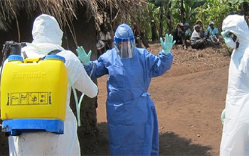 Credit and Larger Version |
October 16, 2014
The following is part ten in a series on the NSF-NIH-USDA Ecology and Evolution of Infectious Diseases (EEID) Program. See parts: one, two, three, four, five, six, seven, eight and nine.
Ebola. The word brings fear of an unseen and potentially lethal enemy. But there are ways to stop its spread, say infectious disease scientists.
Quick intervention is needed, according to the researchers, who recently published their findings in the journal Eurosurveillance.
Analyzing Ebola cases in Nigeria, a country with success in containing the disease, the scientists estimated the rate of fatality, transmission progression, proportion of health care workers infected, and the effect of control interventions on the size of the epidemic.
Rapid response needed
"Rapid control is necessary, as is demonstrated by the Nigerian success story," says Arizona State University (ASU) scientist Gerardo Chowell, senior author of the paper.
"This is critically important for countries in the West Africa region that are not yet affected by the Ebola epidemic, as well as for countries in other regions of the world that risk importation of the disease."
The research is funded by the U.S. National Science Foundation (NSF)-National Institutes of Health (NIH)-Department of Agriculture (USDA) Ecology and Evolution of Infectious Diseases (EEID) Program.
"Controlling a deadly disease like Ebola requires understanding how it's likely to spread, and knowing the ways of managing that spread that are most likely to be effective," says Sam Scheiner, NSF EEID program director.
"Being able to respond quickly needs a foundation of knowledge acquired over many years. The work of these scientists is testimony to long-term funding by the EEID program."
Control measures in Nigeria
The largest Ebola outbreak to date is ongoing in West Africa, with more than 8,000 reported cases and 4,000 deaths. However, just 20 Ebola cases have been reported in Nigeria, with no new cases since early September.
All the cases in Nigeria stem from a single traveler returning from Liberia in July.
The study used epidemic modeling and computer simulations to project the size of the outbreak in Nigeria if control interventions had been implemented during various time periods after the initial case, and estimated how many cases had been prevented by the actual early interventions.
"This timely work demonstrates how computational simulations, informed by data from health care officials and the complex social web of contacts and activities, can be used to develop both preparedness plans and response scenarios," says Sylvia Spengler, program director in NSF's Directorate for Computer and Information Science and Engineering, which also supported the research.
Control measures implemented in Nigeria included holding all people showing Ebola symptoms in an isolation ward if they had had contact with the initial case. If Ebola was confirmed through testing, people diagnosed with the disease were moved to a treatment center.
Asymptomatic individuals were separated from those showing symptoms; those who tested negative without symptoms were discharged.
Those who tested negative but showed symptoms--fever, vomiting, sore throat and diarrhea--were observed and discharged after 21 days if they were then free of symptoms, while being kept apart from people who had tested positive.
Brief window of opportunity
Ebola transmission is dramatically influenced by how rapidly control measures are put into place.
"Actions taken by health authorities to contain the spread of disease sometimes can, perversely, spread it," says NSF-funded scientist Charles Perrings, also of ASU.
"In the Nigeria case, people who tested negative but had some of the symptoms were not put alongside others who tested positive," says Perrings. "So they had no incentive to flee, and their isolation did nothing to increase infection rates. Elsewhere in the region isolation policies have had a different effect."
The researchers found that the projected effect of control interventions in Nigeria ranged from 15-106 cases when interventions are put in place on day 3; 20-178 cases when implemented on day 10; 23-282 cases on day 20; 60-666 cases on day 30; 39-1,599 cases on day 40; and 93-2,771 on day 50.
The person who was initially infected generated 12 secondary cases in the first generation of the disease; five secondary cases were generated from those 12 in the second generation; and two secondary cases in the third generation.
That leads to a rough estimate of the reproduction number according to disease generation declining from 12 during the first generation, to approximately 0.4 during the second and third disease generations.
A reproductive number above 1.0 indicates that the disease has the potential to spread.
Recent estimates of the reproduction number for the ongoing Ebola epidemic in Sierra Leone and Liberia range between 1.5 and 2 (two new cases for each single case), indicating that the outbreak has yet to be brought under control.
The effectiveness of the Nigerian response, scientists say, is illustrated by a dramatic decrease in the number of secondary cases over time.
The success story for Nigeria, they maintain, sets a hopeful example for other countries, including the United States.
Co-authors of the Eurosurveillance paper are Gerardo Chowell, Arizona State University; Folorunso Oludayo Fasina, University of Pretoria, South Africa; Aminu Shittu, Usmanu Danfodiyo University, Nigeria; David Lazarus, National Veterinary Research Institute, Plateau State, Nigeria; Oyewale Tomori, Nigerian Academy of Science, University of Lagos, Lagos, Nigeria; Lone Simonsen, George Washington University, Washington, D. C.; and Cecile Viboud, National Institutes of Health, Bethesda, Md.
| -- | Cheryl Dybas, NSF (703) 292-7734 cdybas@nsf.gov |
| -- | Julie Newberg, ASU (480) 727-3116 julie.newberg@asu.edu |
Related Programs Ecology and Evolution of Infectious Disease
Related WebsitesNSF Special Report: Ecology and Evolution of Infectious Diseases: http://www.nsf.gov/news/special_reports/ecoinf/NSF Grant: US-UK Collab: Risks of Animal and Plant Infectious Diseases through Trade (RAPID Trade):
http://www.nsf.gov/awardsearch/showAward?AWD_ID=1414374&HistoricalAwards=false
NSF Grant: III: Small: Data Management for Real-Time Data Driven Epidemic Spread Simulations: http://www.nsf.gov/awardsearch/showAward?AWD_ID=1318788&HistoricalAwards=false
NSF News: Outbreak: Ecology and Evolution of Infectious Disease grants support research on disease transmission:
http://www.nsf.gov/news/news_summ.jsp?cntn_id=129280
Particles of the Ebola virus have found their way to several African countries--and beyond.
Credit and Larger Version

Global health security depends on how fast an infection is recognized and brought under control.
Credit and Larger Version
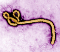
Ebola, as seen under a transmission electron microscope.
Credit and Larger Version
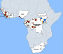
Outbreak distribution map of Ebola in Africa, since its first known incidence.
Credit and Larger Version
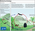
How does Ebola begin? To find answers, look to the ecology of infectious diseases.
Credit and Larger Versión
The National Science Foundation (NSF)
Guillermo Gonzalo Sánchez Achutegui
ayabaca@gmail.com
ayabaca@hotmail.com
ayabaca@yahoo.com


