lunes, 24 de febrero de 2014

NASA : Global Precipitation Measurement Mission Launch Site at JAXA's Tanegashima Space Center


Global Precipitation Measurement Mission Launch Site at JAXA's Tanegashima Space Center
The launch pads at the Japan Aerospace Exploration Agency’s (JAXA) Tanegashima Space Center on Tanegashima Island, Japan are seen on Friday, Feb. 21, 2014, a week ahead of the planned launch of an H-IIA rocket carrying the Global Precipitation Measurement (GPM) Core Observatory. GPM is an international mission led by NASA and JAXA to measure rain and snowfall over most of the globe multiple times a day. To get that worldwide view of precipitation, multiple satellites will be contributing observations for a global data set, all unified by the advanced measurements of GPM's Core Observatory, built at NASA's Goddard Space Flight Center in Greenbelt, Md.
Launch of the GPM Core Observatory from Tanegashima Space Center is scheduled for Thursday, Feb. 27 during a window beginning at 1:07 p.m. EST (3:07 a.m. on Friday, Feb. 28 Japan time).
Image Credit: NASA/Bill Ingalls
NASA
Guillermo Gonzalo Sánchez Achutegui

martes, 18 de febrero de 2014

NASA : Orion Underway Recovery Testing Begins off the Coast of California

 
Preparations are underway to load the test version of Orion on a U.S. Navy ship in San Diego, California.
Preparations are underway to load a test version of the Orion crew module on a U.S. Navy ship in San Diego, California, for an underway recovery test in the Pacific Ocean.
Image Credit: NASA
 
By Linda Herridge
NASA's John F. Kennedy Space Center
About a hundred miles off the coast of San Diego, in the Pacific Ocean, a U.S. Navy ship’s well deck filled with water as underway recovery operations began Feb. 18 on a test version of NASA's Orion crew module to prepare for its first mission, Exploration Flight Test-1, in September. Orion was undocked from its cradle and allowed to float out to sea.
Building on the knowledge gained from previous Orion recovery tests performed in calm waters near NASA's Langley Research Center in Virginia, the agency's Ground Systems Development and Operations (GSDO) Program began the next phase, seeking turbulent water off the west coast in which to practice recovering the Orion crew module, one parachute and a forward bay cover, which keeps Orion's parachutes safe until being jettisoned, just before the parachutes are needed.
“This is an end-to-end test that takes us to the edge of our safe zone,” said Mike Generale, the Orion recovery operations manager and test director at NASA's Kennedy Space Center in Florida. “It will help us see how successful our processes and hardware are to recover Orion in higher sea swells.”
During the recovery test, controllers at Johnson Space Center in Houston simulated the launch and splash down of the Orion capsule. An F-18 jet flew from 13,000 feet into a dive to simulate Orion’s descent through the atmosphere and splashdown, as Johnson confirmed tracking and cleared the air space. Helicopters were stationed in the air to observe the “Orion capsule” during descent, as they would be during an actual retrieval mission.
The ship circled around to the floating test vehicle, and an integrated team of U.S. Navy amphibious specialists, engineers and technicians from Kennedy, Johnson and Lockheed Martin Space Operations practiced retrieving Orion, the forward bay cover and parachute.
A sea anchor and recovery winch was attached to Orion. The recovery winch attachments were secured between Orion’s two main windows, near the heat shield.
For the underway recovery test, even though there are no propellants or coolant on the capsule, the small boat teams examined Orion for leaks, just as they will following Exploration Flight Test-1. Then, two rigid-hull inflatable boats and two smaller Zodiac boats were used to help guide Orion into the Navy ship’s flooded well deck and secure it in a specially designed cradle. Water was drained from the well deck, leaving Orion secure and dry.
Two more rigid-hull inflatable boats were used to secure and reposition the recovered forward bay cover and parachute to the port side of the Navy ship where a crane lifted them on the ship’s main deck.
Generale said the underway recovery test allows GSDO to verify recovery operations and procedures, demonstrates capabilities and incorporates partnership efforts with the U.S. Navy and Lockheed Martin.
“The next steps will be to incorporate lessons learned and, if needed, modify Orion recovery hardware,” Generale said.
The underway recovery test will continue through Feb. 21.
For more information about Orion,
NASA
Guillermo Gonzalo Sánchez Achutegui
 

NASA : IGR J11014-6103: Runaway Pulsar Firing an Extraordinary Jet


IGR J11014-6103: Runaway Pulsar Firing an Extraordinary Jet
An extraordinary jet trailing behind a runaway pulsar is seen in this composite image that contains data from NASA's Chandra X-ray Observatory (purple), radio data from the Australia Compact Telescope Array (green), and optical data from the 2MASS survey (red, green, and blue). The pulsar - a spinning neutron star - and its tail are found in the lower right of this image. The tail stretches for 37 light years , making it the longest jet ever seen from an object in the Milky Way galaxy, as described in our press release.
The pulsar, originally discovered by ESA's INTEGRAL satellite, is called IGR J1104-6103 and is moving away from the center of the supernova remnant where it was born at a speed between 2.5 million and 5 million miles per hour. This supersonic pace makes IGR J1104-6103 one of the fastest moving pulsars ever observed.
A massive star ran out of fuel and collapsed to form the pulsar along with the supernova remnant, the debris field seen as the large purple structure in the upper left of the image. The supernova remnant (known as SNR MSH 11-61A) is elongated along the top-right to bottom left direction, roughly in line with the tail's direction. These features and the high speed of the pulsar suggest that jets could have played an important role in the supernova explosion that formed IGR J1104-6103.
In addition to its exceptional length, the tail behind IGR J1104-6103 has other interesting characteristics. For example, there is a distinct corkscrew pattern in the jet. This pattern suggests that the pulsar is wobbling like a top as it spins, while shooting off the jet of particles.
Another interesting feature of this image is a structure called a pulsar wind nebula (PWN), a cocoon of high-energy particles that enshrouds the pulsar and produces a comet-like tail behind it. Astronomers had seen the PWN in previous observations, but the new Chandra and ATCA data show that the PWN is almost perpendicular to the direction of the jet. This is intriguing because usually the pulsar's direction of motion, its jet, and its PWN are aligned with one another.
One possibility requires an extremely fast rotation speed for the iron core of the star that exploded as the supernova. A problem with this scenario is that such fast speeds are not commonly expected to be achievable.
A paper, led by Lucia Pavan of the University of Geneva in Switzerland, describing these results appears in the February 18th issue of the journal Astronomy & Astrophysics and is also available online. Other authors include Pol Bordas (University of Tuebingen in Germany), Gerd Puehlhofer (Univ. of Tuebingen), Miroslav Filipovic (University of Western Sydney in Australia), A. De Horta (Univ. of Western Sydney), A. O'Brien (Univ. of Western Sydney), M. Balbo (Univ. of Geneva), R. Walter (Univ. of Geneva), E. Bozzo (Univ. of Geneva), C. Ferrigno (Univ. of Geneva), E. Crawford (Univ. of Western Sydney), and L. Stella (INAF).
Image credit: X-ray: NASA/CXC/ISDC/L.Pavan et al, Radio: CSIRO/ATNF/ATCA Optical: 2MASS/UMass/IPAC-Caltech/NASA/NSF
NASA
Guillermo Gonzalo Sánchez Achutegui

domingo, 16 de febrero de 2014

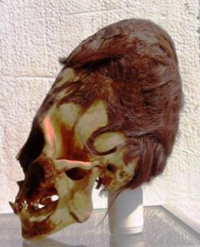
CIENCIA: Nos siguen soprendiendo los descubrimientos de la Cultura Paracas tales como la formación de sus cráaneos

Los cráneos Paracas revelan datos sobre una nueva criatura humana


Paracas es una península desértica situada dentro de la provincia de Pisco, en la Región Ica, en la costa sur del Perú. Es aquí donde el arqueólogo peruano, Julio Tello, hizo un descubrimiento increíble en 1928, un grande y elaborado cementerio que contenía tumbas llenas de los restos de individuos con los cráneos alargados más grandes del mundo. Estos han llegado a ser conocidos como los "Cráneos Paracas". En total, Tello encontró más de 300 de estos cráneos alargados que, se cree, datan de unos 3.000 años.
Un reciente análisis de ADN llevado a cabo por el experto Brien Foerster, en uno de los cráneos, ha arrojado información preliminar sobre estos enigmáticos cráneos.


Es bien conocido que la mayoría de los casos de alargamiento son el resultado de la deformación craneal por aplanamiento de la cabeza; en la que el cráneo se deforma intencionalmente mediante la aplicación de fuerza durante un largo período de tiempo. Sin embargo, mientras que esta deformación cambia la forma del cráneo, no altera su volumen, peso u otras características que son propias de un cráneo humano normal.
Los cráneos Paracas, sin embargo, son diferentes. El volumen craneal es hasta un 25 por ciento más grande y un 60 por ciento más pesados que los cráneos humanos convencionales, lo que significa que no podían haber sido deformados intencionalmente a través del aplanamiento u otra técnica. También contienen sólo una placa parietal, en lugar de dos. El hecho de que las características de los cráneos "no son el resultado de la deformación craneana intencional” significa que la causa de su alargamiento es un misterio, y lo ha sido durante décadas.
El doctor Juan Navarro, director del museo local, llamado el Museo de Historia de Paracas, que alberga una colección de 35 de los cráneos, permitió la toma de muestras de 5 de ellos. Se tomaron muestras de cabello, incluyendo las raíces, un diente, hueso del cráneo y de la piel; proceso que fue cuidadosamente documentado a través de fotos y video. Las muestras de los tres cráneos fueron enviados para su estudio genético, sin proporcionar a la genetista mayores detalles sobre esta, a fin de no crear ninguna idea preconcebida.


Brien Foerster, autor de más de diez libros y una autoridad en el estudio de este antiguo pueblo de cabezas alargadas de América del Sur, recibió los resultados del análisis de ADN e hizo revelaciones preliminares sorprendentes.
El hallazgos del genetista indica que los cráneos Paracas poseen ADNmt (ADN mitocondrial) con mutaciones desconocidas en cualquier ser humano, primate, o animal conocido hasta ahora. Los pocos fragmentos que se pudieron secuenciar hasta el momento, indican que si estas mutaciones aparecen en todas las muestras se trataría de una nueva criatura humana, muy distante del Homo Sapiens, los neandertales y los homínidos de Denisova.
Las implicaciones son, por supuesto, enormes, manifestó Foerster; quién, además, tiene la sospecha de que estos individuos, inclusive, no caben en el árbol evolutivo conocido. De manera que si los habitantes de Paracas fueron tan biológicamente diferentes, no habrían sido capaces de cruzarse con humanos.
Sin embargo, hay que esperar la conclusión de todas las fases del proceso de análisis. Este es solo el resultado de la fase uno de las muchas que se realizarán. Las próximas pruebas implicarán, también, la replicación de la prueba inicial, el cual se llevará a cabo con otros cráneos, para que los resultados puedan ser comparados con el fin de ver si hay algunas características específicas de los Paracas.
- Información de Ciencia Peruana
Guillermo Gonzalo Sánchez Achutegui
ayabaca@gmail.com
ayabaca@hotmail.com
ayabaca@yahoo.com

miércoles, 12 de febrero de 2014

NASA : NASA Awards Information Technology Contract

Largest Solar System Moon Detailed in Geologic Map

Youtube Override:
Animation of a rotating globe of Jupiter's moon Ganymede, with a geologic map superimposed over a global color mosaic. The 37-second animation begins as a global color mosaic image of the moon then quickly fades in the geologic map.
Image Credit:
USGS Astrogeology Science Ctr/Wheaton/ASU/NASA/JPL-Caltech
Ganymede global geologic map
To present the best information in a single view of Jupiter's moon Ganymede, a global image mosaic was assembled, incorporating the best available imagery from NASA's Voyager 1 and 2 spacecraft and NASA's Galileo spacecraft.
Image Credit:
USGS Astrogeology Science Center/Wheaton/NASA/JPL-Caltech

More than 400 years after its discovery by astronomer Galileo Galilei, the largest moon in the solar system – Jupiter's moon Ganymede – has finally claimed a spot on the map.
A group of scientists led by Geoffrey Collins of Wheaton College has produced the first global geologic map of Ganymede, Jupiter’s seventh moon. The map combines the best images obtained during flybys conducted by NASA's Voyager 1 and 2 spacecraft (1979) and Galileo orbiter (1995 to 2003) and is now published by the U. S. Geological Survey as a global map. It technically illustrates the varied geologic character of Ganymede’s surface and is the first global, geologic map of this icy, outer-planet moon.
“This map illustrates the incredible variety of geological features on Ganymede and helps to make order from the apparent chaos of its complex surface,” said Robert Pappalardo of NASA’s Jet Propulsion Laboratory in Pasadena, Calif. “This map is helping planetary scientists to decipher the evolution of this icy world and will aid in upcoming spacecraft observations.”
The European Space Agency's Jupiter Icy Moons Explorer mission is slated to be orbiting Ganymede around 2032. NASA is contributing a U.S.-led instrument and hardware for two European-led instruments for the mission.
Since its discovery in January 1610, Ganymede has been the focus of repeated observation, first by Earth-based telescopes, and later by the flyby missions and spacecraft orbiting Jupiter. These studies depict a complex, icy world whose surface is characterized by the striking contrast between its two major terrain types: the dark, very old, highly cratered regions, and the lighter, somewhat younger (but still very old) regions marked with an extensive array of grooves and ridges.
According to the scientists who have constructed this map, three major geologic periods have been identified for Ganymede that involve the dominance of impact cratering, then tectonic upheaval, followed by a decline in geologic activity. The map, which illustrates surface features, such as furrows, grooves and impact craters, allows scientists to decipher distinct geologic time periods for an object in the outer solar system for the first time.
“The highly detailed, colorful map confirmed a number of outstanding scientific hypotheses regarding Ganymede’s geologic history, and also disproved others,” said Baerbel Lucchitta, scientist emeritus at the U.S. Geological Survey in Flagstaff, Ariz., who has been involved with geologic mapping of Ganymede since 1980. “For example, the more detailed Galileo images showed that cryovolcanism, or the creation of volcanoes that erupt water and ice, is very rare on Ganymede.”
The Ganymede global geologic map will enable researchers to compare the geologic characters of other icy satellite moons, because almost any type of feature that is found on other icy satellites has a similar feature somewhere on Ganymede.
“The surface of Ganymede is more than half as large as all the land area on Earth, so there is a wide diversity of locations to choose from,” Collins said. Ganymede also shows features that are ancient alongside much more recently formed features, adding historical diversity in addition to geographic diversity.”
Amateur astronomers can observe Ganymede (with binoculars) in the evening sky this month, as Jupiter is in opposition and easily visible.
The project was funded by NASA through its Outer Planets Research and Planetary Geology and Geophysics Programs. NASA's Jet Propulsion Laboratory is managed by the California Institute of Technology, Pasadena.
NASA
Guillermo Gonzalo Sánchez Achutegui

NASA : Set of NanoRacks CubeSats Deployed From International Space Station


Set of NanoRacks CubeSats Deployed From International Space Station
ISS038-E-045009 (11 Feb. 2014) --- The Small Satellite Orbital Deployer (SSOD), in the grasp of the Kibo laboratory robotic arm, is photographed by an Expedition 38 crew member on the International Space Station as it deploys a set of NanoRacks CubeSats. The CubeSats program contains a variety of experiments such as Earth observations and advanced electronics testing. Station solar array panels, Earth’s horizon and the blackness of space provide the backdrop for the scene.
Image Credit: NASA
NASA
Guillermo Gonzalo Sánchez Achutegui
ayabaca@gmail.com
ayabaca@hotmail.com
ayabaca@yahoo.com

martes, 11 de febrero de 2014

NASA : Landsat 8's First Year


Landsat 8's First Year
On Feb. 11, 2013, the Landsat 8 satellite rocketed into a sunny California morning onboard a powerful Atlas V and began its life in orbit. In the year since launch, scientists have been working to understand the information the satellite has been sending back. Some have been calibrating the data—checking it against ground observations and matching it to the rest of the 42-year-long Landsat record. At the same time, the broader science community has been learning to use the new data.
The map above—one of the first complete views of the United States from Landsat 8—is an example of how scientists are testing Landsat 8 data. David Roy, a co-leader of the USGS-NASA Landsat science team and researcher at South Dakota State University, made the map with observations taken during August 2013 by the satellite’s Operational Land Imager.
The strips in the image above are a result of the way Landsat 8 operates. Like its predecessors, Landsat 8 collects data in 185-kilometer (115-mile) wide strips called swaths or paths. Each orbit follows a predetermined ground track so that the same path is imaged each time an orbit is repeated. It takes 233 paths and 16 days to cover all of the land on Earth. This means that every land surface has the potential to be imaged once every 16 days, giving Roy two or three opportunities to get a cloud-free view of each pixel in the United States in a month.
Image Credit: NASA/David Roy
NASA
Guillermo Gonzalo Sánchez Achutegui
ayabaca@gmail.com
ayabaca@hotmail.com
ayabaca@yahoo.com

miércoles, 5 de febrero de 2014

NASA : NASA-Sponsored 'Disk Detective' Lets Public Search for New Planetary Nurseries

NASA is inviting the public to help astronomers discover embryonic planetary systems hidden among data from the agency's Wide-field Infrared Survey Explorer (WISE) mission through a new website, DiskDetective.org.
Disk Detective is NASA's largest crowdsourcing project whose primary goal is to produce publishable scientific results. It exemplifies a new commitment to crowdsourcing and open data by the United States government.
Youtube Override:
Take a tour of DiskDetective.org with Goddard astrophysicist Marc Kuchner, the project's principal investigator.
Image Credit: NASA's Goddard Space Flight Center
Feature Link:

"Through Disk Detective, volunteers will help the astronomical community discover new planetary nurseries that will become future targets for NASA's Hubble Space Telescope and its successor, the James Webb Space Telescope," said James Garvin, the chief scientist for NASA Goddard's Sciences and Exploration Directorate.
WISE was designed to survey the entire sky at infrared wavelengths. From a perch in Earth orbit, the spacecraft completed two scans of the entire sky between 2010 and 2011. It took detailed measurements on more than 745 million objects, representing the most comprehensive survey of the sky at mid-infrared wavelengths currently available.

Herbig-Haro 30
Herbig-Haro 30 is the prototype of a gas-rich young stellar object disk. The dark disk spans 40 billion miles in this image, cutting the bright nebula in two and blocking the central star from direct view. Volunteers can help astronomers find more disks like this through DiskDetective.org.
Image Credit: NASA/ESA/C. Burrows (STScI)
 
debris disk around the bright star Fomalhaut
Debris disks, such as this one around the bright star Fomalhaut, tend to be older than 5 million years, possess little or no gas, and contain belts of rocky or icy debris that resemble the asteroid and Kuiper belts found in our own solar system. The radial streaks are scattered starlight.
Image Credit: NASA/ESA/UC Berkeley/Goddard/LLNL/JPL
Marc Kuchner (left) and James Garvin
Marc Kuchner, the principal investigator for DiskDetective.org (left) and James Garvin, the chief scientist for NASA Goddard's Sciences and Exploration Directorate, discuss the crowdsourcing project in front of the hyperwall at Goddard's Science Visualization Lab.
Image Credit:
NASA's Goddard Space Flight Center/David Friedlander

Astronomers have used computers to search this haystack of data for planet-forming environments and narrowed the field to about a half-million sources that shine brightly in the infrared, indicating they may be "needles": dust-rich disks that are absorbing their star's light and reradiating it as heat.
"Planets form and grow within disks of gas, dust and icy grains that surround young stars, but many details about the process still elude us," said Marc Kuchner, an astrophysicist at NASA's Goddard Space Flight Center in Greenbelt, Md. "We need more examples of planet-forming habitats to better understand how planets grow and mature."
But galaxies, interstellar dust clouds, and asteroids also glow in the infrared, which stymies automated efforts to identify planetary habitats. There may be thousands of nascent solar systems in the WISE data, but the only way to know for sure is to inspect each source by eye, which poses a monumental challenge.
Public participation in scientific research is a type of crowdsourcing known as citizen science. It allows the public to make critical contributions to the fields of science, technology, engineering and mathematics by collecting, analyzing and sharing a wide range of data. NASA uses citizen science to engage the public in problem-solving.
Kuchner recognized the spotting of planetary nurseries as a perfect opportunity for crowdsourcing. He arranged for NASA to team up with the Zooniverse, a collaboration of scientists, software developers and educators who collectively develop and manage citizen science projects on the Internet. The result of their combined effort is Disk Detective.
Disk Detective incorporates images from WISE and other sky surveys in brief animations the website calls flip books. Volunteers view a flip book and classify the object based on simple criteria, such as whether the image is round or includes multiple objects. By collecting this information, astronomers will be able to assess which sources should be explored in greater detail, for example, to search for planets outside our solar system.
"Disk Detective's simple and engaging interface allows volunteers from all over the world to participate in cutting-edge astronomy research that wouldn't even be possible without their efforts," said Laura Whyte, director of citizen science at Adler Planetarium in Chicago, Ill., a founding partner of the Zooniverse collaboration.
The project aims to find two types of developing planetary environments. The first, known as a young stellar object disk, typically is less than 5 million years old, contains large quantities of gas, and often is found in or near young star clusters. For comparison, our own solar system is 4.6 billion years old. The second planetary environment, known as a debris disk, tends to be older than 5 million years, possesses little or no gas, and contains belts of rocky or icy debris that resemble the asteroid and Kuiper belts found in our own solar system. Vega and Fomalhaut, two of the brightest stars in the sky, host debris disks.
WISE was shut down in 2011 after its primary mission was completed. But in September 2013, it was reactivated, renamed Near-Earth Object Wide-field Infrared Survey Explorer (NEOWISE), and given a new mission, which is to assist NASA's efforts to identify the population of potentially hazardous near-Earth objects (NEOs). NEOWISE also can assist in characterizing previously detected asteroids that could be considered potential targets for future exploration missions.
NASA's Jet Propulsion Laboratory (JPL) in Pasadena, Calif., manages and operates WISE for NASA's Science Mission Directorate. The WISE mission was selected competitively under NASA's Explorers Program managed by the agency's Goddard Space Flight Center. The science instrument was built by the Space Dynamics Laboratory in Logan, Utah. The spacecraft was built by Ball Aerospace & Technologies Corp. in Boulder, Colo. Science operations and data processing take place at the Infrared Processing and Analysis Center at the California Institute of Technology, which manages JPL for NASA.
For more information about Disk Detective, please visit:
For more information about NASA's WISE mission, visit:
NASA
Guillermo Gonzalo Sánchez Achutegui