Mostrando entradas con la etiqueta NASA's Jet Propulsion Laboratory (JPL). Mostrar todas las entradas

domingo, 8 de junio de 2014

NASA : NASA Beams "Hello, World!" Video from Space via Laser


NASA Beams Video From Space via Laser

06.06.14 - NASA successfully beamed a high-definition video 260 miles from the International Space Station to Earth Thursday using a new laser communications instrument. Transmission of "Hello, World!" as a video message was the first 175-megabit communication for the Optical Payload for Lasercomm Science (OPA ...

Asteroid Discovered by NASA to Pass Earth Safely


06.06.14 - A newfound asteroid will safely pass Earth on June 8 from a distance of about 777,000 miles (1.25 million km), more than three times farther away than our moon. Designated 2014 HQ124, the asteroid was discovered April 23, 2014, by NASA's NEOWISE mission, a space telescope adapted for scouting the sk ...
  • Progress Ready to Undock From ISS Monday Morning

    06.06.14 - Expedition 40 is preparing to take out the trash when a resupply craft undocks Monday morning. The ISS Progress 53 (53P) cargo craft has been filled with trash and discarded gear. It will undock from the aft end of the Zvezda service module Monday at 9:30 a.m. EDT. The crew is also counting down to ...
  • NASA Helps 'Angry Birds Space' Find Asteroids!

    06.05.14 - After a couple of years and hundreds of millions of downloads, the space-based struggle between birds and pigs moves beyond the International Space Station and Mars, and deeper into the final frontier. The latest update from Rovio Entertainment sends Angry Birds Space into NASA’s next target for fut ...
  • NASA's Orion Spacecraft is Ready to Feel the Heat

    06.05.14 - NASA and Lockheed Martin engineers have installed the largest heat shield ever constructed on the crew module of the agency's Orion spacecraft. The work marks a major milestone on the path toward the spacecraft's first launch in December. Orion’s flight test, or Exploration Flight Test-1, will provi ...
  • New Suspect Identified in Supernova Explosion

    06.04.14 - Supernovas are often thought of as tremendous explosions that mark the ends of massive stars' lives, but not all supernovas occur in this fashion. A common supernova class, Type Ia, involves the detonation of white dwarfs -- small, dense stars that are already dead. New results from NASA's Spitzer S ...
  • Hubble Unveils Most Colorful View of Universe Captured

    06.03.14 - Astronomers using NASA's Hubble Space Telescope have assembled a comprehensive picture of the evolving universe – among the most colorful deep space images ever captured by the 24-year-old telescope. Researchers say the image, in new study called the Ultraviolet Coverage of the Hubble Ultra Deep Fie ...
  • Black Hole ‘Batteries’ Keep Blazars Going and Going

    06.03.14 - Astronomers studying two classes of black-hole-powered galaxies monitored by NASA's Fermi Gamma-ray Space Telescope have found evidence that they represent different sides of the same cosmic coin. By unraveling how these objects, called blazars, are distributed throughout the universe, the scientist ...
  • Like Apollo 10, EFT-1 Prepares for Future Missions

    06.03.14 - NASA recently marked the 45th anniversary of Apollo 10, the mission that served as the "dress rehearsal" for the first lunar landing two months later. The agency now is preparing to launch its first human-rated spacecraft capable of not only a trip to the moon, but beyond. Performance during re-ent ...
  • How NASA Builds a Space Laser

    06.03.14 - To build a satellite that will measure all the bumps and dips of our dynamic Earth, engineers started with a black box, built of a composite honeycomb material to make it as light as possible. The structure was precisely manufactured with an opening to allow lasers to beam to Earth, and other window ...
NASA successfully beamed a high-definition video 260 miles from the International Space Station to Earth Thursday using a new laser communications instrument.
Transmission of "Hello, World!" as a video message was the first 175-megabit communication for the Optical Payload for Lasercomm Science (OPALS), a technology demonstration that allows NASA to test methods for communication with future spacecraft using higher bandwidth than radio waves.
"The International Space Station is a test bed for a host of technologies that are helping us increase our knowledge of how we operate in space and enable us to explore even farther into the solar system," said Sam Scimemi, International Space Station division director at NASA Headquarters in Washington. "Using the space station to investigate ways we can improve communication rates with spacecraft beyond low-Earth orbit is another example of how the orbital complex serves as a stepping stone to human deep space exploration."
Optical communication tools like OPALS use focused laser energy to reach data rates between 10 and 1,000 times higher than current space communications, which rely on radio portions of the electromagnetic spectrum.
Because the space station orbits Earth at 17,500 mph, transmitting data from the space station to Earth requires extremely precise targeting. The process can be equated to a person aiming a laser pointer at the end of a human hair 30 feet away and keeping it there while walking.
To achieve this extreme precision during Thursday’s demonstration, OPALS locked onto a laser beacon emitted by the Optical Communications Telescope Laboratory ground station at the Table Mountain Observatory in Wrightwood, California, and began to modulate the beam from its 2.5-watt, 1,550-nanometer laser to transmit the video. The entire transmission lasted 148 seconds and reached a maximum data transmission rate of 50 megabits per second. It took OPALS 3.5 seconds to transmit each copy of the "Hello World!" video message, which would have taken more than 10 minutes using traditional downlink methods.
"It's incredible to see this magnificent beam of light arriving from our tiny payload on the space station," said Matt Abrahamson, OPALS mission manager at NASA's Jet Propulsion Laboratory (JPL) in Pasadena, California. "We look forward to experimenting with OPALS over the coming months in hopes that our findings will lead to optical communications capabilities for future deep space exploration missions."
The OPALS Project Office is based at JPL, where the instrument was built.  OPALS arrived to the space station April 20 aboard SpaceX's Dragon cargo spacecraft and is slated to run for a prime mission of 90 days.
View the "Hello, World!" video transmission and animation of the transmission between OPALS and the ground station, at:
For more information about OPALS, visit:
For more information about the International Space Station, visit:
 
NASA
Guillermo Gonzalo Sánchez Achutegui

domingo, 9 de marzo de 2014

NASA: NASA Radar Demonstrates Ability to Foresee Sinkholes


Aerial photo of a 25-acre sinkhole that formed unexpectedly near Bayou Corne, La., in Aug. 2012.
Image Credit:
On Wings of Care, New Orleans, La.
Analyses by NASA's UAVSAR after the Bayou Corne, La., sinkhole formed show it detected precursory ground movement of up to 10.2 inches (260 millimeters) more than a month before the sinkhole collapsed. Colors represent surface displacement (one full color wrap equals 4.7 inches (120 millimeters).
Image Credit: NASA/JPL-Caltech
Sinkhole map
Sinkholes are common hazards worldwide and are found in all regions of the United States. This map shows parts of the United States where certain rock types are susceptible to dissolving in water, leading to the formation of underground cavities that can result in sinkholes.
Image Credit:
U.S. Geological Survey
New analyses of NASA airborne radar data collected in 2012 reveal the radar detected indications of a huge sinkhole before it collapsed and forced evacuations near Bayou Corne, La. that year.

The findings suggest such radar data, if collected routinely from airborne systems or satellites, could at least in some cases foresee sinkholes before they happen, decreasing danger to people and property.
Sinkholes are depressions in the ground formed when Earth surface layers collapse into caverns below. They usually form without warning. The data were collected as part of an ongoing NASA campaign to monitor sinking of the ground along the Louisiana Gulf Coast.
Researchers Cathleen Jones and Ron Blom of NASA's Jet Propulsion Laboratory (JPL) in Pasadena, Calif., analyzed interferometric synthetic aperture radar (InSAR) imagery of the area acquired during flights of the agency's Uninhabited Airborne Vehicle Synthetic Aperture Radar (UAVSAR), which uses a C-20A jet, in June 2011 and July 2012. InSAR detects and measures very subtle deformations in Earth's surface.
Their analyses showed the ground surface layer deformed significantly at least a month before the collapse, moving mostly horizontally up to 10.2 inches (260 millimeters) toward where the sinkhole would later form. These precursory surface movements covered a much larger area -- about 1,640 by 1,640 feet, (500 by 500 meters) -- than that of the initial sinkhole, which measured about 2 acres (1 hectare).
Results of the study are published in the February issue of the journal Geology.
"While horizontal surface deformations had not previously been considered a signature of sinkholes, the new study shows they can precede sinkhole formation well in advance," said Jones. "This kind of movement may be more common than previously thought, particularly in areas with loose soil near the surface."
The Bayou Corne sinkhole formed unexpectedly Aug. 3, 2012, after weeks of minor earthquakes and bubbling natural gas that provoked community concern. It was caused by the collapse of a sidewall of an underground storage cavity connected to a nearby well operated by Texas Brine Company and owned by Occidental Petroleum. On-site investigation revealed the storage cavity, located more than 3,000 feet (914 meters) underground, had been mined closer to the edge of the subterranean Napoleonville salt dome than thought. The sinkhole, which filled with slurry --a fluid mixture of water and pulverized solids-- has gradually expanded and now measures about 25 acres (10.1 hectares) and is at least 750 feet (229 meters) deep. It is still growing.
"Our work shows radar remote sensing could offer a monitoring technique for identifying at least some sinkholes before their surface collapse, and could be of particular use to the petroleum industry for monitoring operations in salt domes," said Blom. "Salt domes are dome-shaped structures in sedimentary rocks that form where large masses of salt are forced upward. By measuring strain on Earth's surface, this capability can reduce risks and provide quantitative information that can be used to predict a sinkhole's size and growth rate."
Typically, sinkholes have no natural external surface drainage, and they form through natural processes and human activities. They occur in regions of "karst" terrain where the rock below the surface can be dissolved by groundwater, most commonly in areas with limestone or other carbonate rocks, gypsum, or salt beds. When the rocks dissolve, they form spaces and caverns underground. Sinkholes vary in size from a few feet across to hundreds of acres, and some can be very deep. They are common hazards worldwide and are found in all regions of the United States, with Florida, Missouri, Texas, Alabama, Kentucky, Tennessee and Pennsylvania reporting the most sinkhole damage. While sinkhole deaths are rare, in February 2013 a man in Tampa, Fla., was killed when his house was swallowed by a sinkhole.
The human-produced Bayou Corne sinkhole occurred in an area not prone to sinkholes. The Gulf Coast of Louisiana and eastern Texas sits on an ancient ocean floor with salt layers that form domes as the lower-density salt rises. The Napoleonville salt dome underneath Bayou Corne extends to within 690 feet (210 meters) of the surface. Various companies mine caverns in the dome by dissolving the salt to obtain brine and subsequently store fuels and salt water in the caverns.
Jones and Blom say continued UAVSAR monitoring of the area as recently as October 2013 has shown a widening area of deformation, with the potential to affect other nearby storage cavities located near the salt dome's outer wall. Because the Bayou Corne sinkhole is now filled with water, it is harder to measure deformation of the area using InSAR. However, if the deformation extends far past the sinkhole boundaries, InSAR could continue to track surface movement caused by changes below the surface.
Continued growth of the sinkhole threatens the community and Highway 70, so there is a pressing need for reliable estimates of how fast it may expand and how big it may eventually get.
"This kind of data could be of great value in determining the direction in which the sinkhole is likely to expand," said Jones. "At Bayou Corne, it appears that material is continuing to flow into the huge cavern that is undergoing collapse."
Blom says there are no immediate plans to fly UAVSAR over sinkhole-prone areas.
"You could spend a lot of time flying and processing data without capturing a sinkhole," he said. "Our discovery at Bayou Corne was really serendipitous. But it does demonstrate one of the expected benefits of an InSAR satellite that would image wide areas frequently.
"Every year, unexpected ground motions from sinkholes, landslides and levee failures cost millions of dollars and many lives," said Jones. "When there is small movement prior to a catastrophic collapse, such subtle precursory clues can be detected by InSAR."
NASA monitors Earth's vital signs from land, air and space with a fleet of satellites and ambitious airborne and ground-based observation campaigns. NASA develops new ways to observe and study Earth's interconnected natural systems with long-term data records and computer analysis tools to better see how our planet is changing. The agency shares this unique knowledge with the global community and works with institutions in the United States and around the world that contribute to understanding and protecting our home planet.
For more information about UAVSAR, visit:
For more information about NASA's Earth science activities in 2014, visit:
For information on the latest NASA Earth science findings, visit:
NASA
Guillermo Gonzalo Sánchez Achutegui

miércoles, 12 de febrero de 2014

NASA : NASA Awards Information Technology Contract

Largest Solar System Moon Detailed in Geologic Map

Youtube Override:
Animation of a rotating globe of Jupiter's moon Ganymede, with a geologic map superimposed over a global color mosaic. The 37-second animation begins as a global color mosaic image of the moon then quickly fades in the geologic map.
Image Credit:
USGS Astrogeology Science Ctr/Wheaton/ASU/NASA/JPL-Caltech
Ganymede global geologic map
To present the best information in a single view of Jupiter's moon Ganymede, a global image mosaic was assembled, incorporating the best available imagery from NASA's Voyager 1 and 2 spacecraft and NASA's Galileo spacecraft.
Image Credit:
USGS Astrogeology Science Center/Wheaton/NASA/JPL-Caltech

More than 400 years after its discovery by astronomer Galileo Galilei, the largest moon in the solar system – Jupiter's moon Ganymede – has finally claimed a spot on the map.
A group of scientists led by Geoffrey Collins of Wheaton College has produced the first global geologic map of Ganymede, Jupiter’s seventh moon. The map combines the best images obtained during flybys conducted by NASA's Voyager 1 and 2 spacecraft (1979) and Galileo orbiter (1995 to 2003) and is now published by the U. S. Geological Survey as a global map. It technically illustrates the varied geologic character of Ganymede’s surface and is the first global, geologic map of this icy, outer-planet moon.
“This map illustrates the incredible variety of geological features on Ganymede and helps to make order from the apparent chaos of its complex surface,” said Robert Pappalardo of NASA’s Jet Propulsion Laboratory in Pasadena, Calif. “This map is helping planetary scientists to decipher the evolution of this icy world and will aid in upcoming spacecraft observations.”
The European Space Agency's Jupiter Icy Moons Explorer mission is slated to be orbiting Ganymede around 2032. NASA is contributing a U.S.-led instrument and hardware for two European-led instruments for the mission.
Since its discovery in January 1610, Ganymede has been the focus of repeated observation, first by Earth-based telescopes, and later by the flyby missions and spacecraft orbiting Jupiter. These studies depict a complex, icy world whose surface is characterized by the striking contrast between its two major terrain types: the dark, very old, highly cratered regions, and the lighter, somewhat younger (but still very old) regions marked with an extensive array of grooves and ridges.
According to the scientists who have constructed this map, three major geologic periods have been identified for Ganymede that involve the dominance of impact cratering, then tectonic upheaval, followed by a decline in geologic activity. The map, which illustrates surface features, such as furrows, grooves and impact craters, allows scientists to decipher distinct geologic time periods for an object in the outer solar system for the first time.
“The highly detailed, colorful map confirmed a number of outstanding scientific hypotheses regarding Ganymede’s geologic history, and also disproved others,” said Baerbel Lucchitta, scientist emeritus at the U.S. Geological Survey in Flagstaff, Ariz., who has been involved with geologic mapping of Ganymede since 1980. “For example, the more detailed Galileo images showed that cryovolcanism, or the creation of volcanoes that erupt water and ice, is very rare on Ganymede.”
The Ganymede global geologic map will enable researchers to compare the geologic characters of other icy satellite moons, because almost any type of feature that is found on other icy satellites has a similar feature somewhere on Ganymede.
“The surface of Ganymede is more than half as large as all the land area on Earth, so there is a wide diversity of locations to choose from,” Collins said. Ganymede also shows features that are ancient alongside much more recently formed features, adding historical diversity in addition to geographic diversity.”
Amateur astronomers can observe Ganymede (with binoculars) in the evening sky this month, as Jupiter is in opposition and easily visible.
The project was funded by NASA through its Outer Planets Research and Planetary Geology and Geophysics Programs. NASA's Jet Propulsion Laboratory is managed by the California Institute of Technology, Pasadena.
NASA
Guillermo Gonzalo Sánchez Achutegui

miércoles, 5 de febrero de 2014

NASA : NASA-Sponsored 'Disk Detective' Lets Public Search for New Planetary Nurseries

NASA is inviting the public to help astronomers discover embryonic planetary systems hidden among data from the agency's Wide-field Infrared Survey Explorer (WISE) mission through a new website, DiskDetective.org.
Disk Detective is NASA's largest crowdsourcing project whose primary goal is to produce publishable scientific results. It exemplifies a new commitment to crowdsourcing and open data by the United States government.
Youtube Override:
Take a tour of DiskDetective.org with Goddard astrophysicist Marc Kuchner, the project's principal investigator.
Image Credit: NASA's Goddard Space Flight Center
Feature Link:

"Through Disk Detective, volunteers will help the astronomical community discover new planetary nurseries that will become future targets for NASA's Hubble Space Telescope and its successor, the James Webb Space Telescope," said James Garvin, the chief scientist for NASA Goddard's Sciences and Exploration Directorate.
WISE was designed to survey the entire sky at infrared wavelengths. From a perch in Earth orbit, the spacecraft completed two scans of the entire sky between 2010 and 2011. It took detailed measurements on more than 745 million objects, representing the most comprehensive survey of the sky at mid-infrared wavelengths currently available.

Herbig-Haro 30
Herbig-Haro 30 is the prototype of a gas-rich young stellar object disk. The dark disk spans 40 billion miles in this image, cutting the bright nebula in two and blocking the central star from direct view. Volunteers can help astronomers find more disks like this through DiskDetective.org.
Image Credit: NASA/ESA/C. Burrows (STScI)
 
debris disk around the bright star Fomalhaut
Debris disks, such as this one around the bright star Fomalhaut, tend to be older than 5 million years, possess little or no gas, and contain belts of rocky or icy debris that resemble the asteroid and Kuiper belts found in our own solar system. The radial streaks are scattered starlight.
Image Credit: NASA/ESA/UC Berkeley/Goddard/LLNL/JPL
Marc Kuchner (left) and James Garvin
Marc Kuchner, the principal investigator for DiskDetective.org (left) and James Garvin, the chief scientist for NASA Goddard's Sciences and Exploration Directorate, discuss the crowdsourcing project in front of the hyperwall at Goddard's Science Visualization Lab.
Image Credit:
NASA's Goddard Space Flight Center/David Friedlander

Astronomers have used computers to search this haystack of data for planet-forming environments and narrowed the field to about a half-million sources that shine brightly in the infrared, indicating they may be "needles": dust-rich disks that are absorbing their star's light and reradiating it as heat.
"Planets form and grow within disks of gas, dust and icy grains that surround young stars, but many details about the process still elude us," said Marc Kuchner, an astrophysicist at NASA's Goddard Space Flight Center in Greenbelt, Md. "We need more examples of planet-forming habitats to better understand how planets grow and mature."
But galaxies, interstellar dust clouds, and asteroids also glow in the infrared, which stymies automated efforts to identify planetary habitats. There may be thousands of nascent solar systems in the WISE data, but the only way to know for sure is to inspect each source by eye, which poses a monumental challenge.
Public participation in scientific research is a type of crowdsourcing known as citizen science. It allows the public to make critical contributions to the fields of science, technology, engineering and mathematics by collecting, analyzing and sharing a wide range of data. NASA uses citizen science to engage the public in problem-solving.
Kuchner recognized the spotting of planetary nurseries as a perfect opportunity for crowdsourcing. He arranged for NASA to team up with the Zooniverse, a collaboration of scientists, software developers and educators who collectively develop and manage citizen science projects on the Internet. The result of their combined effort is Disk Detective.
Disk Detective incorporates images from WISE and other sky surveys in brief animations the website calls flip books. Volunteers view a flip book and classify the object based on simple criteria, such as whether the image is round or includes multiple objects. By collecting this information, astronomers will be able to assess which sources should be explored in greater detail, for example, to search for planets outside our solar system.
"Disk Detective's simple and engaging interface allows volunteers from all over the world to participate in cutting-edge astronomy research that wouldn't even be possible without their efforts," said Laura Whyte, director of citizen science at Adler Planetarium in Chicago, Ill., a founding partner of the Zooniverse collaboration.
The project aims to find two types of developing planetary environments. The first, known as a young stellar object disk, typically is less than 5 million years old, contains large quantities of gas, and often is found in or near young star clusters. For comparison, our own solar system is 4.6 billion years old. The second planetary environment, known as a debris disk, tends to be older than 5 million years, possesses little or no gas, and contains belts of rocky or icy debris that resemble the asteroid and Kuiper belts found in our own solar system. Vega and Fomalhaut, two of the brightest stars in the sky, host debris disks.
WISE was shut down in 2011 after its primary mission was completed. But in September 2013, it was reactivated, renamed Near-Earth Object Wide-field Infrared Survey Explorer (NEOWISE), and given a new mission, which is to assist NASA's efforts to identify the population of potentially hazardous near-Earth objects (NEOs). NEOWISE also can assist in characterizing previously detected asteroids that could be considered potential targets for future exploration missions.
NASA's Jet Propulsion Laboratory (JPL) in Pasadena, Calif., manages and operates WISE for NASA's Science Mission Directorate. The WISE mission was selected competitively under NASA's Explorers Program managed by the agency's Goddard Space Flight Center. The science instrument was built by the Space Dynamics Laboratory in Logan, Utah. The spacecraft was built by Ball Aerospace & Technologies Corp. in Boulder, Colo. Science operations and data processing take place at the Infrared Processing and Analysis Center at the California Institute of Technology, which manages JPL for NASA.
For more information about Disk Detective, please visit:
For more information about NASA's WISE mission, visit:
NASA
Guillermo Gonzalo Sánchez Achutegui
 

jueves, 23 de enero de 2014

NASA : Herschel Telescope Detects Water on Dwarf Planet

 
 Dwarf planet Ceres is located in the main asteroid belt, between the orbits of Mars and Jupiter, as illustrated in this artist's conception. Observations by the Herschel space observatory between 2011 and 2013 find that the dwarf planet has a thin water vapor atmosphere.
Dwarf planet Ceres is located in the main asteroid belt, between the orbits of Mars and Jupiter, as illustrated in this artist's conception. Observations by the Herschel space observatory between 2011 and 2013 find that the dwarf planet has a thin water vapor atmosphere.
Image Credit: ESA/ATG medialab
Image Token:
Scientists using the Herschel space observatory have made the first definitive detection of water vapor on the largest and roundest object in the asteroid belt, Ceres.
Plumes of water vapor are thought to shoot up periodically from Ceres when portions of its icy surface warm slightly. Ceres is classified as a dwarf planet, a solar system body bigger than an asteroid and smaller than a planet.
Herschel is a European Space Agency (ESA) mission with important NASA contributions.
"This is the first time water vapor has been unequivocally detected on Ceres or any other object in the asteroid belt and provides proof that Ceres has an icy surface and an atmosphere," said Michael Küppers of ESA in Spain, lead author of a paper in the journal Nature.
The results come at the right time for NASA's Dawn mission, which is on its way to Ceres now after spending more than a year orbiting the large asteroid Vesta. Dawn is scheduled to arrive at Ceres in the spring of 2015, where it will take the closest look ever at its surface.
"We've got a spacecraft on the way to Ceres, so we don't have to wait long before getting more context on this intriguing result, right from the source itself," said Carol Raymond, the deputy principal investigator for Dawn at NASA's Jet Propulsion Laboratory (JPL) in Pasadena, Calif. "Dawn will map the geology and chemistry of the surface in high-resolution, revealing the processes that drive the outgassing activity."
For the last century, Ceres was known as the largest asteroid in our solar system. But in 2006, the International Astronomical Union, the governing organization responsible for naming planetary objects, reclassified Ceres as a dwarf planet because of its large size. It is roughly 590 miles (950 kilometers) in diameter. When it first was spotted in 1801, astronomers thought it was a planet orbiting between Mars and Jupiter. Later, other cosmic bodies with similar orbits were found, marking the discovery of our solar system's main belt of asteroids.
Scientists believe Ceres contains rock in its interior with a thick mantle of ice that, if melted, would amount to more fresh water than is present on all of Earth. The materials making up Ceres likely date from the first few million years of our solar system's existence and accumulated before the planets formed.
Until now, ice had been theorized to exist on Ceres but had not been detected conclusively. It took Herschel's far-infrared vision to see, finally, a clear spectral signature of the water vapor. But Herschel did not see water vapor every time it looked. While the telescope spied water vapor four different times, on one occasion there was no signature.
Here is what scientists think is happening: when Ceres swings through the part of its orbit that is closer to the sun, a portion of its icy surface becomes warm enough to cause water vapor to escape in plumes at a rate of about 6 kilograms (13 pounds) per second. When Ceres is in the colder part of its orbit, no water escapes.
The strength of the signal also varied over hours, weeks and months, because of the water vapor plumes rotating in and out of Herschel's views as the object spun on its axis. This enabled the scientists to localize the source of water to two darker spots on the surface of Ceres, previously seen by NASA's Hubble Space Telescope and ground-based telescopes. The dark spots might be more likely to outgas because dark material warms faster than light material. When the Dawn spacecraft arrives at Ceres, it will be able to investigate these features.
The results are somewhat unexpected because comets, the icier cousins of asteroids, are known typically to sprout jets and plumes, while objects in the asteroid belt are not.
"The lines are becoming more and more blurred between comets and asteroids," said Seungwon Lee of JPL, who helped with the water vapor models along with Paul von Allmen, also of JPL. "We knew before about main belt asteroids that show comet-like activity, but this is the first detection of water vapor in an asteroid-like object."
The research is part of the Measurements of 11 Asteroids and Comets Using Herschel (MACH-11) program, which used Herschel to look at small bodies that have been or will be visited by spacecraft, including the targets of NASA's previous Deep Impact mission and upcoming Origins Spectral Interpretation Resource Identification Security Regolith Explorer (OSIRIS-Rex). Laurence O' Rourke of the European Space Agency is the principal investigator of the MACH-11 program.
 
More information about Herschel is online at:
More information about NASA's role in Herschel is available at:
For more information about NASA's Dawn mission, visit:
NASA
Guillermo Gonzalo Sánchez Achutegui

domingo, 8 de diciembre de 2013

NASA : NASA Initiative Helps Launch Student-Built Satellites

Thinking Inside the Box, Launching into Space
NASA CubeSats heading into orbit
The NROL-39 GEMSat mission lifted off from California's Vandenberg Air Force Base on Dec. 5, 2013, aboard a United Launch Alliance Atlas V rocket.
Image Credit: P. Corkery/ULA
Image Token:
Artist's concept of CubeSat
Artist's concept of the Intelligent Payload Experiment (IPEX) and M-Cubed/COVE-2, two NASA Earth-orbiting cube satellites ("CubeSats") that were launched as part of the NROL-39 GEMSat mission from California's Vandenberg Air Force Base on Dec. 5, 2013.
Image Credit: NASA/JPL-Caltech
Image Token:
Two tiny, cube-shaped research satellites hitched a ride to Earth orbit to validate new hardware and software technologies for future NASA Earth-observing instruments.
The cube satellites, or “CubeSats,” which typically have a volume of exactly 33.814 ounces (1 liter), were launched on a United Launch Alliance Atlas V rocket at 11:14 p.m. PST last night (Dec. 5) from California's Vandenberg Air Force Base as part of the NROL-39 GEMSat mission. Led by NASA's Jet Propulsion Laboratory, Pasadena, Calif., and developed with university and industry partners, these two CubeSats will help enable near-real-time processing capabilities relevant to future climate science measurements.
One of the CubeSats that launched was developed in collaboration with California Polytechnic State University, San Luis Obispo, and is called the Intelligent Payload Experiment, or IPEX. It enables imagery to be transmitted more rapidly from satellite missions back to Earth. By using new software and algorithms, the spacecraft can sift through the data, looking only for the most important images that the scientists urgently need on the ground. This method is designed to speed delivery time of critical data products from days to minutes.
“IPEX will demonstrate software that will enable future NASA missions to recognize science events such as flooding, volcanism and wildfires, and respond by sending alerts and autonomously acquiring follow-up imagery,” said Steve Chien of JPL, principal investigator for the IPEX mission.
The other CubeSat launched is the Michigan Multipurpose Mini-satellite/CubeSat On-board processing Validation Experiment, or M-Cubed/COVE.
M-Cubed, developed in partnership with the University of Michigan, Ann Arbor, will image Earth. The COVE payload will use these data to validate an instrument image data processing algorithm that will greatly reduce the science data transmission rate required for on-orbit operations.
“The COVE payload will advance processor and algorithm technology designed for use in a future science instrument to characterize properties of aerosols and clouds, which will help our understanding of global climate change,” said Paula Pingree of JPL, principal investigator of the MCubed/COVE-2 mission.
These technology validation missions are sponsored by NASA’s Earth Science Technology Office. They are designed to satisfy their science objectives within six months, but will remain in Earth orbit for many years.
The California Institute of Technology in Pasadena manages JPL for NASA.
For additional information on NASA's CubeSat Launch Initiative program, visit:
David Israel 818-354-4797
Jet Propulsion Laboratory, Pasadena, Calif.
david.israel@jpl.nasa.gov
Joshua Buck 202-358-1100
NASA Headquarters, Washington
jbuck@nasa.gov
NASA
Guillermo Gonzalo Sánchez Achutegui

domingo, 22 de septiembre de 2013

NASA - NASA Launches Study of New Global Land Imaging System

NASA's Deep Space Comet Hunter Mission Comes to an End
 
Artist's concept of NASA's Deep Impact spacecraft
Artist's concept of NASA's Deep Impact spacecraft,
Image Credit: NASA/JPL-Caltech
Image Token:
Feature Link:

PASADENA, Calif. - After almost 9 years in space that included an unprecedented July 4th impact and subsequent flyby of a comet, an additional comet flyby, and the return of approximately 500,000 images of celestial objects, NASA's Deep Impact mission has ended.
The project team at NASA's Jet Propulsion Laboratory in Pasadena, Calif., has reluctantly pronounced the mission at an end after being unable to communicate with the spacecraft for over a month. The last communication with the probe was Aug. 8. Deep Impact was history's most traveled comet research mission, going about 4.7 billion miles (7.58 billion kilometers).
"Deep Impact has been a fantastic, long-lasting spacecraft that has produced far more data than we had planned," said Mike A'Hearn, the Deep Impact principal investigator at the University of Maryland in College Park. "It has revolutionized our understanding of comets and their activity."
Deep Impact successfully completed its original bold mission of six months in 2005 to investigate both the surface and interior composition of a comet, and a subsequent extended mission of another comet flyby and observations of planets around other stars that lasted from July 2007 to December 2010. Since then, the spacecraft has been continually used as a space-borne planetary observatory to capture images and other scientific data on several targets of opportunity with its telescopes and instrumentation.
Launched in January 2005, the spacecraft first traveled about 268 million miles (431 million kilometers) to the vicinity of comet Tempel 1. On July 3, 2005, the spacecraft deployed an impactor into the path of comet to essentially be run over by its nucleus on July 4. This caused material from below the comet’s surface to be blasted out into space where it could be examined by the telescopes and instrumentation of the flyby spacecraft. Sixteen days after that comet encounter, the Deep Impact team placed the spacecraft on a trajectory to fly back past Earth in late December 2007 to put it on course to encounter another comet, Hartley 2 in November 2010.
"Six months after launch, this spacecraft had already completed its planned mission to study comet Tempel 1," said Tim Larson, project manager of Deep Impact at JPL. "But the science team kept finding interesting things to do, and through the ingenuity of our mission team and navigators and support of NASA’s Discovery Program, this spacecraft kept it up for more than eight years, producing amazing results all along the way."
The spacecraft's extended mission culminated in the successful flyby of comet Hartley 2 on Nov. 4, 2010. Along the way, it also observed six different stars to confirm the motion of planets orbiting them, and took images and data of Earth, the moon and Mars. These data helped to confirm the existence of water on the moon, and attempted to confirm the methane signature in the atmosphere of Mars. One sequence of images is a breathtaking view of the moon transiting across the face of Earth.
In January 2012, Deep Impact performed imaging and accessed the composition of distant comet C/2009 P1 (Garradd). It took images of comet ISON this year and collected early images of ISON in June.
After losing contact with the spacecraft last month, mission controllers spent several weeks trying to uplink commands to reactivate its onboard systems. Although the exact cause of the loss is not known, analysis has uncovered a potential problem with computer time tagging that could have led to loss of control for Deep Impact's orientation. That would then affect the positioning of its radio antennas, making communication difficult, as well as its solar arrays, which would in turn prevent the spacecraft from getting power and allow cold temperatures to ruin onboard equipment, essentially freezing its battery and propulsion systems.
“Despite this unexpected final curtain call, Deep Impact already achieved much more than ever was envisioned," said Lindley Johnson, the Discovery Program Executive at NASA Headquarters, and the Program Executive for the mission since a year before it launched. "Deep Impact has completely overturned what we thought we knew about comets and also provided a treasure trove of additional planetary science that will be the source data of research for years to come.”
The mission is part of the Discovery Program managed at NASA's Marshall Space Flight Center in Huntsville, Ala. JPL manages the Deep Impact mission for NASA's Science Mission Directorate in Washington. Ball Aerospace & Technologies Corp. of Boulder, Colo., built the spacecraft. The California Institute of Technology in Pasadena manages JPL for NASA.
To find out more about Deep Impact's scientific results, visit:
For more information about Deep Impact, visit:
NASA
Guillermo Gonzalo Sánchez Achutegui

domingo, 11 de agosto de 2013

NASA - NASA Administrator Tours Earth Missions Under Construction in California

NASA Administrator Charles Bolden will visit the agency's Jet Propulsion Laboratory (JPL) in Pasadena, Calif., Tuesday, Aug. 13, to see progress on two Earth-observing missions currently undergoing preparation for launch in 2014.
Media are invited to accompany Bolden and JPL Director Charles Elachi on the tour at 1:30 p.m. PDT. Bolden will meet with the spacecraft teams, give some brief comments to media and answer questions.
Journalists who want to participate must arrange access through Elena Mejia of JPL Media Relations by 3 p.m. Monday, Aug. 12, by sending an email to elena.mejia@jpl.nasa.gov.
Media who have responded and would like to enter the clean room where the two spacecraft are located must arrive at JPL no later than 12:15 p.m. Aug. 13 to don special gear and have any recording equipment cleaned. Media entering the clean room must wear flat, close-toed shoes and long pants.
Media who do not want to enter the clean room should arrive by 12:45 p.m. to view the event from an enclosed overhead gallery, where an audio feed will be available. Contact Mejia if you have any questions regarding the technical setup and allowable equipment in the clean room.
The spacecraft Bolden will see are the Soil Moisture Active Passive (SMAP) mission, scheduled to launch in October 2014, and the International Space Station (ISS)-RapidScat instrument, which is set for launch to the orbiting laboratory in April 2014.
These missions will add to NASA’s suite of space and airborne research that contribute to scientists' understanding of weather and climate and efforts to improve life on Earth and protect our planet.
SMAP will produce global maps scientists can use to track water availability around our planet and guide policy decisions. It will improve the accuracy of short-term weather forecasts and long-term projections of climate change and provide vital early-warning information on agricultural crop yields.
ISS-RapidScat is a scatterometer that will be mounted on the exterior of the International Space Station to collect information on the speed and direction of winds near the ocean surface in Earth’s low and mid-latitudes. The instrument also will be used to calibrate other ocean winds satellites. The data it generates will help improve weather forecasts, including tracking of storms and hurricanes, and our understanding of how interactions between Earth’s ocean and atmosphere influence our climate.
JPL manages SMAP for NASA’s Science Mission Directorate in Washington. ISS-RapidScat is a joint partnership of JPL and NASA's International Space Station Program Office at the agency's Johnson Space Center in Houston, with support from the agency's Science Mission Directorate in Washington.
For more information on NASA's Earth science program, visit:
 
'Like Butter': Study Explains Surprising Acceleration of Greenland's Inland Ice
Surface meltwater draining through cracks in an ice sheet can warm the sheet from the inside, softening the ice and letting it flow faster, a new NASA-funded study finds.
During the last decade, researchers have captured compelling evidence of accelerating ice flow at terminal regions, or “snouts,” of Greenland glaciers as they flow into the ocean along the western coast. Now, the new research shows that the interior regions are also flowing much faster than they were in the winter of 2000-2001, and the study authors propose a reason for the speedup.
“Through satellite observations, we determined that an inland region of the Sermeq Avannarleq Glacier, 40 to 60 miles from the coast, is flowing about 1.5 times faster than it was about a decade ago,” said Thomas Phillips, lead author of the new paper and a research associate at the time of the study with the Cooperative Institute for Research in Environmental Sciences at the University of Colorado, Boulder.
The researchers used ice-sheet-wide velocity maps for Greenland from a NASA program called Making Earth System Data Records for Use in Research Environments. Studying the velocity maps, the researchers saw that in 2000-2001 the inland segment of the Sermeq Avannarleq Glacier was flowing at about 130 feet (40 meters) per year. In 2007-2008, that speed was closer to 200 feet (60 meters) per year.
Youtube Override:

This animation shows how ice is naturally transported from interior topographic divides on Greenland to its coast via glaciers. The colors represent the speed of ice flow, with areas in red and purple flowing the fastest at rates of kilometers per year. The vectors indicate the direction of flow.
Image Token:
Feature Link:
“At first, we couldn’t explain this rapid interior acceleration,” Phillips said. “We knew it wasn’t related to what was going on at the glacier’s terminus. The speedup had to be due to changes within the ice itself.”
To shed light on the observed acceleration, Phillips and his team developed a new model to investigate the effects of meltwater on the ice sheet’s physical properties. The team found that percolating meltwater carries heat from the sun and warms the ice sheet, which then—like a warm stick of butter—softens, deforms and flows faster.
Previous studies estimated that it would take centuries to millennia for new climates to increase the temperature deep within ice sheets. But when the influence of meltwater is considered, warming can occur within decades and, thus, produce rapid accelerations. The paper has been accepted for publication in the Journal of Geophysical Research: Earth Surface, a journal of the American Geophysical Union.
The researchers were tipped off to this mechanism by the massive amount of meltwater they observed on the ice sheet’s surface during their summer field campaigns, and they wondered if it was affecting the ice sheet. During the last several decades, atmospheric warming above the Greenland Ice Sheet has caused an expanding area of the surface to melt during the summer, creating pools of water that gush down cracks in the ice. The meltwater eventually funnels to the interior and bed of the ice sheet.
“The sun melts ice into water at the surface, and that water then flows into the ice sheet carrying a tremendous amount of latent energy,” said William Colgan, a coauthor and adjunct research associate with the University of Colorado’s Cooperative Institute for Research in Environmental Sciences. “The latent energy then heats the ice.”
The new model shows that this speeds up ice flow in two major ways: One, the retained meltwater warms the bed of the ice sheet and preconditions it to accommodate a basal water layer, making it easier for the ice sheet to slide by lubrication. Two, warmer ice is also softer (less viscous), which makes it flow more readily.
“Basically, the gravitational force driving the ice sheet flow hasn’t changed over time, but with the ice sheet becoming warmer and softer, that same gravitational force now makes the ice flow faster,” Colgan said.
This transformation from stiff to soft only requires a little bit of extra heat from meltwater. “The model shows that a slight warming of the ice near the ice sheet bed—only a couple of degrees Celsius—is sufficient to explain the widespread acceleration,” Colgan said.
The findings have important ramifications for ice sheets and glaciers everywhere. “It could imply that ice sheets can discharge ice into the ocean far more rapidly than currently estimated,” Phillips said. “It also means that the glaciers are not finished accelerating and may continue to accelerate for a while. As the area experiencing melt expands inland, the acceleration may be observed farther inland.”
The study’s results suggest that to understand future sea-level rise, scientists need to account for a previously overlooked factor — meltwater’s latent energy — and its potential role in making glaciers and ice sheets flow faster into the world’s oceans. In 2007, the Intergovernmental Panel on Climate Change wrote that one of the most significant challenges in predicting sea-level rise was “limited” understanding of the processes controlling ice flow. The panel’s next assessment is due out in 2014.
“Traditionally, latent energy has been considered a relatively unimportant factor, but most glaciers are now receiving far more meltwater than they used to and are increasing in temperature faster than previously imagined,” Colgan said. “The chunk of butter known as the Greenland Ice Sheet may be softening a lot faster than we previously thought possible.”
The study was funded through a NASA ROSES grant, NASA’s Greenland Climate Network and the National Science Foundation. Other coauthors on the paper were CIRES Director Waleed Abdalati, who is also former chief scientist for NASA; former CIRES Director Konrad Steffen; and CU-Boulder engineering professor Harihar Rajaram.
Adapted by NASA/Maria-José Viñas Garcia
Based on press release by CIRES/Katy Human and AGU/Peter Weiss
NASA
Guillermo Gonzalo Sánchez Achutegui

martes, 15 de enero de 2013

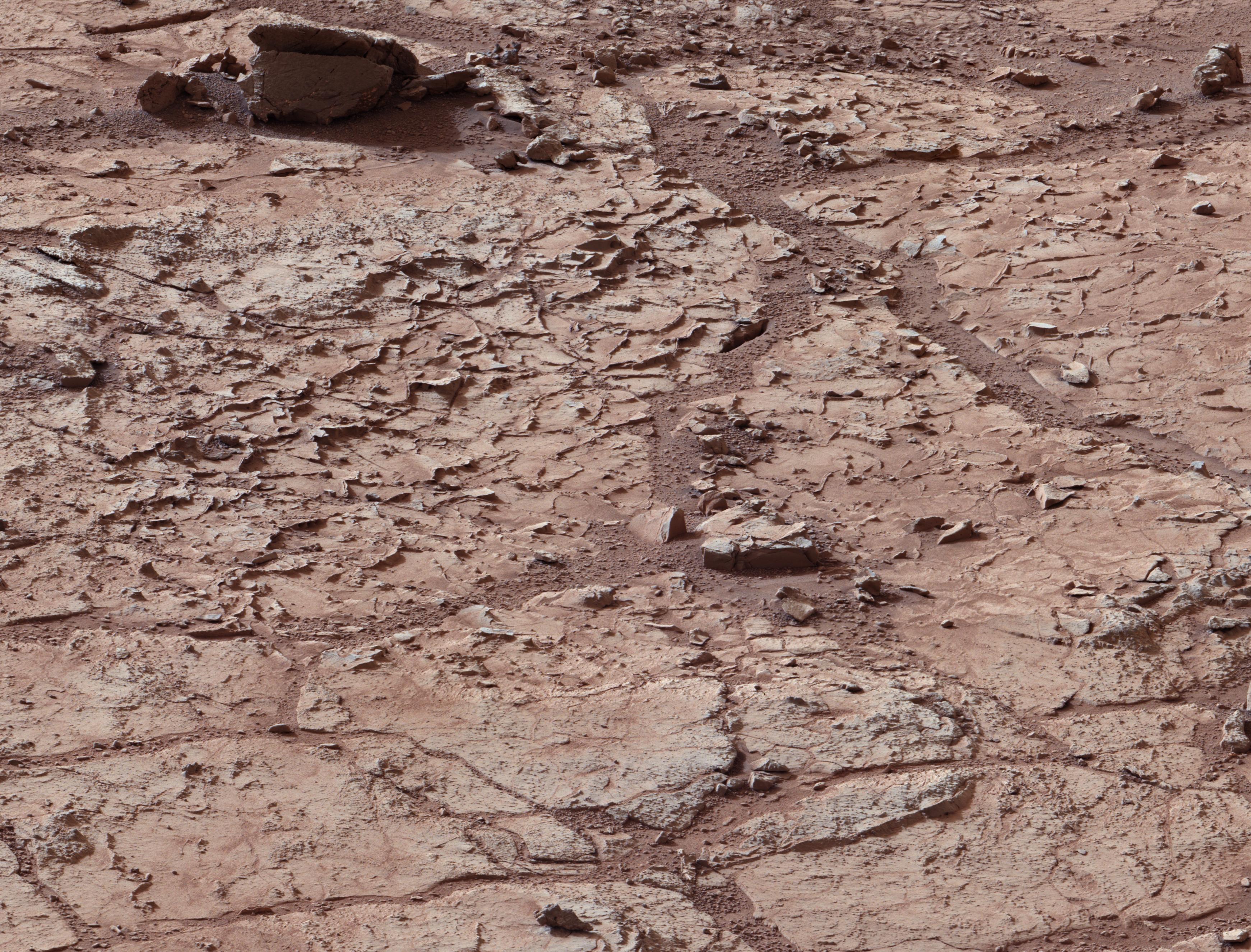
NASA - NASA Mars Rover Preparing to Drill Into First Martian Rock


http://photojournal.jpl.nasa.gov/jpegMod/PIA16567_modest.jpg

Full-Res TIFF: PIA16567.tif (27.71 MB)
Full-Res JPEG: PIA16567.jpg (1.787 MB)  

NASA Mars Rover Preparing to Drill Into First Martian Rock 
PASADENA, Calif. -- NASA's Mars rover Curiosity is driving toward a flat rock with pale veins that may hold clues to a wet history on the Red Planet. If the rock meets rover engineers' approval when Curiosity rolls up to it in coming days, it will become the first to be drilled for a sample during the Mars Science Laboratory mission.

The size of a car, Curiosity is inside Mars' Gale Crater investigating whether the planet ever offered an environment favorable for microbial life. Curiosity landed in the crater five months ago to begin its two-year prime mission.

"Drilling into a rock to collect a sample will be this mission's most challenging activity since the landing. It has never been done on Mars," said Mars Science Laboratory project manager Richard Cook of NASA's Jet Propulsion Laboratory (JPL) in Pasadena, Calif. "The drill hardware interacts energetically wiGale Craterth Martian material we don't control. We won't be surprised if some steps in the process don't go exactly as planned the first time through."

Curiosity first will gather powdered samples from inside the rock and use those to scrub the drill. Then the rover will drill and ingest more samples from this rock, which it will analyze for information about its mineral and chemical composition.

The chosen rock is in an area where Curiosity's Mast Camera (Mastcam) and other cameras have revealed diverse unexpected features, including veins, nodules, cross-bedded layering, a lustrous pebble embedded in sandstone, and possibly some holes in the ground.
The rock chosen for drilling is called "John Klein" in tribute to former Mars Science Laboratory deputy project manager John W. Klein, who died in 2011.

"John's leadership skill played a crucial role in making Curiosity a reality," said Cook.

The target is on flat-lying bedrock within a shallow depression called "Yellowknife Bay." The terrain in this area differs from that of the landing site, a dry streambed about a third of a mile (about 500 meters) to the west. Curiosity's science team decided to look there for a first drilling target because orbital observations showed fractured ground that cools more slowly each night than nearby terrain types do.

"The orbital signal drew us here, but what we found when we arrived has been a great surprise," said Mars Science Laboratory project scientist John Grotzinger, of the California Institute of Technology in Pasadena. "This area had a different type of wet environment than the streambed where we landed, maybe a few different types of wet environments."

One line of evidence comes from inspection of light-toned veins with Curiosity's laser-pulsing Chemistry and Camera (ChemCam) instrument, which found elevated levels of calcium, sulfur and hydrogen.

"These veins are likely composed of hydrated calcium sulfate, such as bassinite or gypsum," said ChemCam team member Nicolas Mangold of the Laboratoire de Planetologie et Geodynamique de Nantes in France. "On Earth, forming veins like these requires water circulating in fractures."

Researchers have used the rover's Mars Hand Lens Imager (MAHLI) to examine sedimentary rocks in the area. Some are sandstone, with grains up to about peppercorn size. One grain has an interesting gleam and bud-like shape that have brought it Internet buzz as a "Martian flower." Other rocks nearby are siltstone, with grains finer than powdered sugar. These differ significantly from pebbly conglomerate rocks in the landing area.

"All of these are sedimentary rocks, telling us Mars had environments actively depositing material here," said MAHLI deputy principal investigator Aileen Yingst of the Planetary Science Institute in Tucson, Ariz. "The different grain sizes tell us about different transport conditions."

JPL manages the Mars Science Laboratory Project for NASA's Science Mission Directorate in Washington.
To see an image of the rock, visit:

For more information about the mission, visit:

Follow the mission on Facebook and Twitter at:
NASA
ayabaca@gmail.com
ayabaca@hotmail.com
ayabaca@yagoo.com