Mostrando entradas con la etiqueta the Persian Gulf. Mostrar todas las entradas

domingo, 28 de octubre de 2012

ESA - Observing the Earth - Earth from Space: Persian coast


Download:
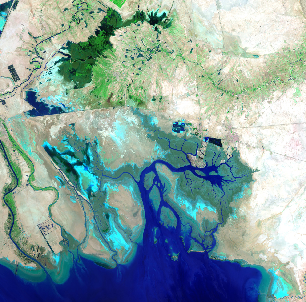
 This image acquired over the Middle East shows the northern end of the Persian Gulf, along with the border of Iran and Iraq and the mouth of the Shatt al-Arab river. In the lower-left corner, we can see the Shatt al-Arab where it creates part of the border with Iraq. The lines cutting through the middle of the image are roads, as well as the Trans-Iranian Railway. The centre of the image is dominated by the marshes and mudflats of the Shadegan wildlife refuge, Iran's largest wetland.
This image was acquired on 26 July 2012 by the Enhanced Thematic Mapper on Landsat 7. 
Credits: USGS/ESA
This image acquired over the Middle East shows the northern end of the Persian Gulf, along with the border of Iran and Iraq and the mouth of the Shatt al-Arab river.

The main part of the image covers Iran’s southern Khuzestan Province on the Persian Gulf.

The lines cutting through the middle of the image are roads, as well as the Trans-Iranian Railway.
In the upper-left corner, we can see part of the Karun River. It is the country’s only navigable river, originating in the Zagros mountains and running its 720 km course southwest and into the Shatt al-Arab river.
In addition to the Karun, the Shatt al-Arab also carries water from the Tigris and Euphrates to the Persian Gulf.
In the lower-left corner, we can see the Shatt al-Arab where it creates part of the border with Iraq. The marshy Faw Peninsula (part of which is visible to the extreme left) is the site of a number of important Iraqi oil installations.
The Persian Gulf and its coastal areas are the world’s largest single source of crude oil, with related industries dominating the region.
The centre of the image is dominated by the marshes and mudflats of the Shadegan wildlife refuge. It is the largest wetland in Iran, and plays a significant role in the natural ecology of the area.
The area provides a wintering habitat for a wide variety of migratory birds, and is the most important site in the world for a rare species of aquatic bird – the marbled duck.
The northern part of the wetland is a vital freshwater habitat for many endangered species.
This image was acquired on 26 July 2012 by the Enhanced Thematic Mapper on Landsat 7. Landsat 7 imagery accounts for the largest parts of Earth’s surface displayed on web mapping services such as Google Earth and Google Maps.  

The Image of the Week is featured on ESA Web-TV, broadcast online every Friday at 10:00 CEST.
ESA
Guillermo Gonzalo Sánchez Achutegui
ayabaca@gmail.com
ayabaca@hotmail.com
ayabaca@yahoo.com

domingo, 14 de octubre de 2012

ESA- Observing the Earth.- Earth from Space: Downtown Dubai


Download:
 HI-RES JPEG (Size: 1115 kb)  HI-RES TIFF (Size: 47 448 kb)
This image acquired on 4 January 2012 by the Pleiades satellite shows part of Dubai in the United Arab Emirates. The light blue area near the centre of the image is the man-made Burj Khalifa Lake. Next to the lake sits a skyscraper that is the tallest man-made structure in the world. Its long shadow is cast to the north (to the right in this image). The large, dark area is where the saltwater Dubai Creek is being extended as part of the construction of the Business Bay development. 
Credits: CNES 2012/Astrium Services/Spot Image.
This image from the Pleiades satellite shows part of Dubai in the United Arab Emirates.

Located south east of the Persian Gulf on the Arabian Peninsula, Dubai lies within the Arabian Desert. The city is a major business hub, and its revenues come from tourism, real estate and financial services.
The light blue area near the centre of the image is the man-made Burj Khalifa Lake. Next to the lake sits a skyscraper that is the tallest man-made structure in the world. Its long shadow is cast to the north (to the right in this image).
Zooming in on the lake, we can see the curves and circles of the Dubai Fountain. The choreographed system shoots water 73 m into the air while accompanied by music.
The building, lake and fountain are part of a development called Downtown Dubai. Covering an area of 2 sq km, the mixed-use complex is estimated to cost US$20 billion.
Another notable structure of Downtown Dubai is the Dubai Mall, which appears as a vast grey structure in this image. It is the world’s largest shopping mall, and is also houses an aquarium and ice rink.
The large, dark area is where the saltwater Dubai Creek is being extended as part of the construction of the Business Bay development. The area is expected to have over 200 buildings for commercial and residential use.
In the upper left portion of the image, we can see Safa Park. It contains three lakes, over 200 species of birds and nearly 17 000 different types of vegetation.
The image was acquired by France’s Pleiades satellite on 4 January.  

The Image of the Week is featured on ESA Web-TV, broadcast online every Friday at 10:00 CEST. 
ESA
Guillermo Gonzalo Sánchez Achutegui
ayabaca@gmail.com
ayabaca@hotmail.com
ayabaca@yahoo.com