Mostrando entradas con la etiqueta European Space Agency(ESA). Mostrar todas las entradas

miércoles, 4 de junio de 2014

NASA : UN PÚLSAR EN LA SUPERNOVA

Un Púlsar en el Interior de la Burbuja de una Supernova

 
 Las estrellas masivas mueren de forma dramática, explotando como espectaculares supernovas que liberan una gran cantidad de masa y energía. Estas explosiones arrastran todo el material de sus alrededores, creando una gran burbuja que se va expandiendo en el medio interestelar. En el corazón de estas burbujas se encuentra una pequeña y densa estrella de neutrones o un agujero negro, los restos de lo que en su día fue una brillante estrella.
Las burbujas formadas por las explosiones de supernova sólo brillan durante unas pocas decenas de miles de años antes de disolverse por completo, por lo que no es fácil detectar una estrella de neutrones o un agujero negro que todavía esté rodeado por su onda expansiva. Esta imagen nos muestra un buen ejemplo de este fenómeno, desvelando una estrella de neutrones en rotación y fuertemente magnetizada – lo que se conoce como un púlsar –  envuelta en su sudario cósmico, los restos de la explosión en la que se formó. 
Este púlsar, conocido como SXP 1062, se encuentra a las afueras de la Pequeña Nube de Magallanes, una de las galaxias satélite de nuestra Vía Láctea, y está devorando el material de la estrella que lo acompaña, lo que provoca potentes emisiones de rayos X. En el futuro esta región presentará un aspecto todavía más dramático, ya que SXP 1062 está acompañado por una estrella masiva que también terminará sus días explotando como una supernova.
Un Púlsar en el Interior de la Burbuja de una Supernova
Un Púlsar en el Interior de la Burbuja de una Supernova. Image Credit: ESA
 
La mayoría de los púlsares presentan un periodo de rotación increíblemente rápido, dando varias vueltas completas cada segundo. Sin embargo, al estudiar la nube de expansión que rodea a SXP 1062, los astrónomos han descubierto que este púlsar está girando demasiado lento. De hecho, es uno de los púlsares más lentos de los que se tiene constancia. 
Si bien la causa de este extraño comportamiento sigue siendo un misterio, la principal hipótesis sugiere que la rotación del púlsar podría estar frenada por su potente campo magnético. 
El resplandor azul en el centro de la burbuja representa las emisiones en rayos X del propio púlsar y del gas caliente que ocupa el interior de la onda expansiva. Los objetos azules que se pueden ver al fondo de la imagen son otras fuentes de rayos X situadas fuera de la galaxia. 
Esta imagen es una combinación de los datos recogidos por el telescopio espacial XMM-Newton de la ESA en la banda de los rayos X (en azul) y de las observaciones realizadas desde el Observatorio Interamericano del Cerro Tololo, en Chile. Al tomar las fotografías desde tierra se utilizaron unos filtros especiales que permiten revelar el brillo del oxígeno (representado en color verde) y el del hidrógeno (en color rojo). La composición nos muestra una región con una extensión de unos 457 años luz. 
NASA
Guillermo Gonzalo Sánchez Achutegui
ayabaca@gmail.com
ayabaca@Hotmail.com
ayabaca@yahoo.com

domingo, 9 de marzo de 2014

ESA : Margarita Island, Venezuela


Situated in the southern Caribbean Sea about 20 km off of mainland Venezuela’s coast, the island comprises two peninsulas linked by a long, narrow strip of land – called an isthmus.
The eastern part of the island is home to most of the island’s residents, while the Macanao peninsula to the west is dominated by a central mountain range.
Between the peninsulas and cut off from the open sea by the isthmus lies the La Restinga lagoon, a national park that appears as a dark green and blue area in this image.
Recognised as a wetland of international importance by the Ramsar Convention, the area features picturesque mangroves and is an important feeding ground for birds such as herons and flamingos. The shallow waters are home to red snappers, sardines and swordfish – among other types of fish – and oysters grow on the mangrove roots.
Japan's ALOS satellite captured this image on 26 June 2010 with its AVNIR-2 Advanced Visible and Near Infrared Radiometer.
ALOS was supported as a Third Party Mission, which means that ESA used its multi-mission ground systems to acquire, process, distribute and archive data from the satellite to its user community.
In April 2011 the satellite abruptly lost power while mapping Japan’s tsunami-hit coastline.
This image is featured on the Earth from Space video programme.
ESA
Guillermo Gonzalo Sánchez Achutegui
ayabaca@gmail.com
ayabaca@hotmail.com
ayabaca@yahoo.com

ESA : Catching signals from a speeding satellite


Catching signals from a speeding satellite

Upgraded station in Spain
7 March 2014
Soaring high above Earth as they speed through space, satellites are difficult targets to track. Now a new approach developed in Europe is helping ground stations to acquire signals faster and more accurately than ever before.
During launch, a satellite is flung into orbit with tremendous force, attaining speeds of over 28 000 km/h – about 40 times faster than a commercial airliner.
A critical moment is when the satellite separates from its rocket and starts transmitting radio signals. A receiving station on the ground has to be ready and waiting, pointed at precisely the right spot in the sky to catch the transmission, which is a highly focused and narrow beam. And it’s moving fast.
“Traditionally, even the best stations – like ESA’s 15 m and 35 m-diameter dishes – are only sensitive across an arc of just a few degrees,” says Magdalena Martinez de Mendijur, a systems engineer at ESA’s Operations Centre in Germany.
“If the antenna is not pointed perfectly, or if the satellite zips by out of its ‘field of view’ before acquisition, the signal could be missed altogether.”

A cutting-edge difference

SARAS – a Spanish acronym for ‘Fast Acquisition of Satellites and Launchers’ – is a circular array of eight small radio-frequency sensors mounted around the rim of an existing dish antenna.
New antenna array
That’s where SARAS – a Spanish acronym for ‘Fast Acquisition of Satellites and Launchers’ – is making a cutting-edge difference.
The system mounts a circular array of eight small radio-frequency sensors around the rim of an existing dish antenna.
“The signals received by these eight are combined, and the system can estimate the direction of arrival of the incoming radio beam, and the entire dish can be repointed directly at the satellite with great precision and accuracy, even when the incoming signal is weak or distorted,” says Magdalena.
It was fitted to the 15 m dish at ESA’s Space Astronomy Centre in Spain in 2013. Since then, it has been extensively tested, catching signals from missions including CryoSat-2, XMM, GOCE and Swarm.

ESA partners with European industry

“This new approach more than doubles the size of the dish’s window and we can acquire signals from a new satellite in less than 12 seconds,” says Klaus Juergen Schulz, responsible for ground station engineering.
“A future version should improve this to just two seconds.”
SARAS for faster satellite tracking
The technology was developed by Spanish company Isdefe, partly supported by ESA’s General Support Technology Programme, which converts promising engineering concepts into mature products.
The system has been patented in Spain and is being patented in Europe, and will be developed into a full commercial product.
“This is an excellent example of how technology research supported through ESA funding and technical and managerial supervision can be developed by European industry into world-class products and services,” says Juan Miro, Head of ESA’s Ground Systems Engineering department.

Related articles
Deep-space stations gain made-in-Europe hearing boost18 July 2013 Picking up ultra-weak signals from spacecraft exploring deep in our Solar System requires cooling a detector to within a few degrees of absolute zero. Thanks to ESA’s support, the technology is now available in Europe for the first time.
ESA
Guillermo Gonzalo Sánchez Achutegui

domingo, 22 de diciembre de 2013

ESA : Let’s get three dimensional


ESA astronaut Thomas Reiter using ERB-1 on ISS in 2006, in 3D
20 December 2013
Almost a million people have watched the YouTube video of ESA’s 3D camera being used in space. Here on Earth, the same camera technology is equally successful.
“3D brings a human and immersive feel to images that nothing else can match,” says Max Collon from Dutch Cosine Research and its subsidiary 3D-ONE.
Cosine developed the ERB-1 and ERB-2 Erasmus Recording Binoculars for ESA and then drew on it to build a line of high-end 3D cameras now being sold worldwide.

Use red/blue stereo glasses to watch
Install the camera over an operating table and hundreds of medical students can follow every step in real time, depth and full HD from anywhere in the world. Place one over a conveyer belt and you can instantly monitor product irregularities by measuring exact sizes and shapes.
ERB-2 camera
ERB-2 high-res 3D camera
“What we do is use the 3D technology we developed with ESA for their ERB cameras and customise it to meet the specific need of our different customers,” adds Max, which was supported by ESA via its Technology Transfer Programme to spin-off the space technology.
 
Space live in 3D
While 3D grabbed the public’s attention in the film Avatarin 2009, depicting life on a fictional planet and space station, it had already been used aboard the real International Space Station three years earlier.
ESA astronaut Thomas Reiter reported in 3D from the orbital outpost in 2006 using the camera’s predecessor, thanks to some forward-thinking by ESA engineers and Cosine’s specialists.
“We wanted our astronauts to shoot films in 3D to promote the Space Station,” says Massimo Sabbatini, Head of ESA’s Erasmus Centre, and the camera’s instigator.
“And they have done so many times since 2006, first with ERB-1, and since 2009 with our high-res ERB-2. Just visit the ESA 3D channel on YouTube.”

Space tech started business

“The design and development of ERB were the catalyst for our spin-off company 3D-ONE, now producing cost-efficient high-end 3D cameras for the commercial non-space market.”
Put on your 3D glasses for this 3D virtual tour of the International Space Station.
Following the first camera’s trial on the Station, Cosine was supported by ESA’s Business Incubation Centre in Noordwijk, the Netherlands, to develop a business plan for commercial spin-offs. The plan pointed to a camera with higher resolution and more capabilities.
“This was back in 2005, before 3D filming was really initiated. We could see that the ERB technology had huge potential on Earth,” adds Max.

ESA started 3D in space

 
ESA is always pushing for novel technology to take space exploration even further. In this case, it was a development back in 2001 for a planetary rover and the wish to report from the Station in 3D that began it all.
“In our research to develop and use stereo vision for rover navigation and telepresence for space missions we saw the potential of using the same equipment for the production of quality 3D video,” explains Gianfran
The International Space Station
co Visentin from ESA’s Automation and Robotics Laboratory.
“We made initially a 3D camera for the rover, to be used in Gianfranco’s lab,” recalls Cosine’s CEO Marco Beijersbergen, “and the people of ESA’s Erasmus Centre saw the potential of having a 3D camera for the Space Station. So we started developing ERB.”
Virtual Reality Theatre
Erasmus Centre's Virtual Reality Theatre
Massimo Sabbatini remembers, “We thought it would be great to promote the Space Station by showing 3D videos in our Virtual Reality Theatre. Visitors could then ‘move’ around the outside of the Station and inside its many modules, taking advantage of the advanced sense of presence offered by our 3D visualisation tools.”
“Despite the commercial and profitable nature of the business, the technology we use has its roots in space, with ESA sowing the first seeds,” emphasises Max.
“But we use more commercial units and customise to different needs in areas as diverse as forensics, medicine, surveillance and quality monitoring.”
More spin-off with ESA support
“In addition to the record-breaking space success confirming the concepts and the 3D technology, we saw great commercial potential for advancing the cameras,” adds Max.
ESA Business Incubation Centres

“That is why in 2011 we again went to ESA’s incubation centre in Noordwijk with the proposal to add hyperspectral imaging, which also has its roots in space programmes, for Earth observation.”
Hyperspectral imaging separates light into its fine component colours that reveal the composition of objects.
Having recently completed its incubation, 3D-ONE is now a steady business producing large volumes of 3D and hyperspectral units for non-space clients.
Cameras destined for space are subjected to many constraints, including mass and power, thermal stability, the necessity to focus, zoom, record, process and store data all within one integrated unit.
Terrestrial conditions are more forgiving, but Max emphasises, “3D-ONE’s customers soon realise that the technology that can perform in space also offers more capabilities.”
3D space tech for police camera

By adding the unique hyperspectral capability gleaned from space, the possibilities multiply. Max says, “For example, a police officer at a crime scene does not have to wait for a lab to tell him how old traces of blood are. Hyperspectral technology can determine its age immediately, by colour alone.”
“The success of 3D-ONE has once again proven the potential of our technology and the worth of our business incubation to support the transfer of leading-edge space technologies to create more businesses with new jobs in Europe,” notes Niels Eldering of ESA’s Technology Transfer Programme Office, which each year helps more than 75 new start-ups at its eight incubation centres to spin off space technology.
“3D-ONE is a prime example of space heritage providing a competitive advantage.”
ESA
Guillermo Gonzalo Sánchez Achutegui
ayabaca@gmail.com
ayabaca@hotmail.com
ayabaca@yahoo.com

domingo, 15 de diciembre de 2013

ESA : Flinders Ranges, South Australia

Flinders Ranges, South Australia
This image from Japan’s ALOS satellite shows part of the Flinders Ranges in South Australia, about 500 km north of Adelaide.
The area pictured is between Flinders Ranges National Park to the south, Vulkathunha-Gammon Ranges National Park to the north and Lake Frome due east (none of which is pictured).
The curving structures that dominate this image are part of a larger geosyncline – a subsiding linear trough in Earth’s crust – that includes the Flinders Ranges. The geosyncline consists of sedimentary rocks in a basin that were folded about 500 million years ago and have been eroded to the current landscape. In this image, the different colours show the different layers of rock.
Some of the oldest fossilised animal life have been found in parts of the Flinders Ranges.
Running up the middle of this image is a long, narrow gorge – typical of the ranges.
Along the right side of the image, the terrain is flat with a long, straight road running north–south. Numerous creeks appear like veins across the entire image.
The Flinders Ranges is one of Australia’s most seismically active regions, with numerous small earthquakes recorded every year.
Japan’s Advanced Land Observation Satellite captured this image on 3 January 2009. ALOS was supported as a Third Party Mission, which means that ESA used its multi-mission ground systems to acquire, process, distribute and archive data from the satellite to its user community.
This image is featured on the Earth from Space video programme.


TAGS

Open/Close

ESA
Guillermo Gonzalo Sánchez Achutegui
ayabaca@gmail.com
ayabaca@hotmail.com
ayabaca@yahoo.com

ESA: Crab Nebula


Crab Nebula  DOWNLOAD HI.RES    JPG    (2.94 MB)
Crab Nebula
Across the Universe, every ending is a new beginning. When a massive star dies, exploding as a spectacular supernova, huge amounts of matter and energy are ejected into surrounding space, and the remnant of the explosion itself remains a hub of fierce activity for thousands of years.
One of the most iconic supernova remnants is the Crab Nebula. A wispy and filamentary cloud of gas and dust, it originated with a supernova explosion that was seen by Chinese astronomers in the year 1054. A spinning neutron star – or pulsar – remains at its centre, releasing streams of highly energetic particles into the nebula.
This composite image combines a new infrared view of the Crab Nebula, obtained with ESA’s Herschel Space Observatory, with an optical image from the archives of the NASA/ESA Hubble Space Telescope.
Herschel’s observations are shown in red and reveal the glow from cosmic dust present in the nebula. Hubble’s view, in blue, traces oxygen and sulphur gas in the nebula.
A team of astronomers studying the nebula with Herschel has revealed that this supernova remnant contains much more dust than they had expected – about a quarter of the mass of the Sun.
The new observations also revealed the presence of molecules containing argon, the first time a noble gas-based molecule has been found in space.
Argon is produced in the nuclear reactions that take place during supernova explosions, and astronomers had already detected this element in the Crab Nebula. However, it is surprising that argon bonded with other elements, forming molecules that survived in the hostile environment of a supernova remnant, with hot gas still expanding at high speeds after the explosion.
Read more about this discovery:
Credits: ESA/Herschel/PACS/MESS Key Programme Supernova Remnant Team; NASA, ESA and Allison Loll/Jeff Hester (Arizona State University)
ESA
Guillermo Gonzalo Sánchez Achutegui
ayabaca@gmail.com
ayabaca@hotmail.com
ayabaca@yahoo.com

domingo, 1 de diciembre de 2013

ESA : Las estaciones de seguimiento de la ESA ayudarán a la misión lunar china

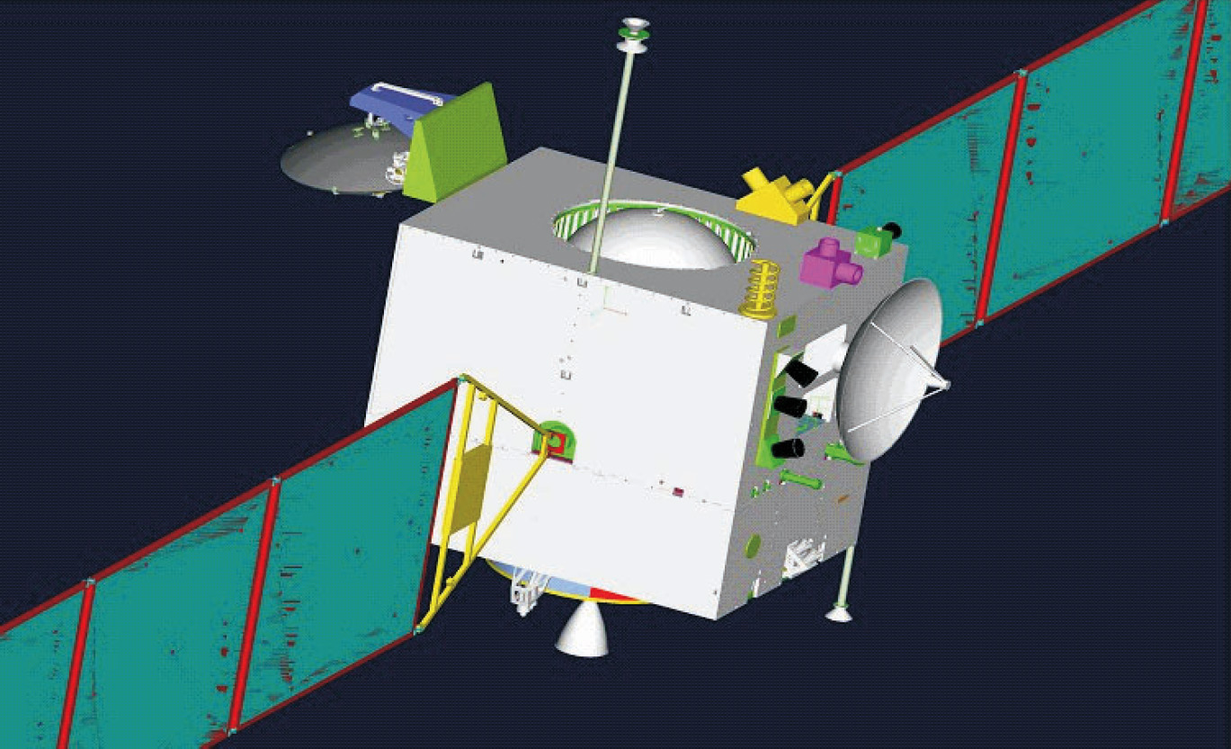
Full resolution(1,369 × 833 pixels, file size: 312 KB, MIME type: image/jpeg)
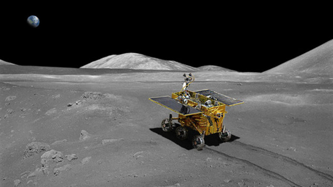
Chang'e 3 is a lunar exploration mission operated by China National Space Administration, incorporating a robotic lander and a rover. Chang'e 3 was successfully launched on 1 December 2013 as part of the second phase of the Chinese Lunar Exploration Program.[4][7][8] It will be China's first lunar rover, and the first spacecraft in 37 years to make a soft landing on the Moon, since the Soviet Luna 24 mission in 1976.[9] It is named after Chang'e, the goddess of the Moon in Chinese mythology, and is a follow-up to the Chang'e 1 and Chang'e 2 lunar orbiters. The lunar probe is also called the Yutu, or Jade Rabbit, a name selected in an online poll that comes from a Chinese myth about a white rabbit that lives on the Moon.[10]
Wikipedia.

Las estaciones de seguimiento de la ESA ayudarán a la misión lunar china
Ariane 5 flight V188 rises above ESA's Estrack station in Kourou, French Guyana
Kourou tracking station
29 noviembre 2013
La red de estaciones de seguimiento de la ESA entrará en acción poco después del lanzamiento de la misión chinaChang’E-3, proporcionando un apoyo crucial durante su viaje de cinco días hacia la Luna.
La misiónChang’E-3, bautizada con el nombre de la diosa de la Luna en la mitología china, despegará el próximo día 1 de diciembre desde la base de lanzamiento Xichang LC-2, en la provincia china de Sichuan, y está formada por una plataforma estacionaria y por un vehículo de exploración lunar de seis ruedas.
La misión aterrizará en la Bahía del Arco Iris (Sinus Iridum) el día 14 de diciembre, en el primer alunizaje suave desde la misión rusa Luna 24, en 1976.

La ESA aportará su experiencia en seguimiento

Instantes después del despegue, la antena de 15 metros de la ESA en Kourou, Guayana Francesa, empezará a prestar apoyo de telecomunicaciones, recibiendo las señales de la misión y enviando comandos en coordinación con el centro de control de la misión en China.
Shortly after China’s Chang’e-3 spacecraft departs Earth to land on the Moon, ESA’s network of tracking stations will swing into action, providing crucial support for the vessel’s five-day lunar cruise.
Chinese Moon rover
La ESA seguirá la misión durante todo el viaje a la Luna. Durante la fase de descenso y después del aterrizaje, utilizará sus estaciones de espacio profundo para proporcionar servicios de localización ultra-precisos.
El apoyo europeo a la misión se coordinará desde el Centro de Control de Estrack, en el Centro Europeo de Operaciones Espaciales de la ESA (ESOC) en Darmstadt, Alemania.
“Estamos orgullosos de que la experiencia de nuestros equipos de dinámica del vuelo y de estaciones de seguimiento, y la sofisticada tecnología de nuestra red global Estrack, puedan ayudar a China a llevar a la Luna una misión de gran relevancia científica”, comenta Thomas Reiter, Director de Vuelos Tripulados y Operaciones de la ESA.
“Una cooperación internacional como ésta es fundamental para las futuras misiones de exploración, tripuladas o robóticas, de los planetas, lunas y asteroides, para el beneficio de todos”.

Siguiendo el progreso de la misión lunar

El lanzamiento deChang’E-3 está programado para el día 1 de diciembre a las 18:00 UTC. La estación de seguimiento de Kourou recibirá sus primeras señales alrededor de las 18:44 UTC.
ESA's Estrack tracking station control room at ESOC, the European Space Operations Centre, Darmstadt
Tracking network control room
Kourou seguirá a la nave hasta que entre en órbita lunar el día 6 de diciembre, y durante su descenso a la superficie de la Luna, previsto para el mediodía del día 14, en coordinación con las estaciones de seguimiento chinas.
El alunizaje y las operaciones en superficie se controlarán desde dos estaciones chinas: Kashi y Jiamusi.
“En cuanto la nave se encuentre sobre la superficie lunar, utilizaremos nuestras antenas de espacio profundo de 35 metros de diámetro en Cebreros, España, y Nueva Norcia, Australia, para determinar su posición utilizando la técnica ‘delta-DOR’, explica Erik Soerensen, responsable del apoyo de seguimiento a misiones externas en el ESOC.
“La técnica ‘delta-DOR’ permite determinar la posición de la nave con una precisión extrema, lo que ayudará a nuestros compañeros chinos a evaluar con precisión el lugar del alunizaje”.

Las estaciones de Cebreros y Nueva Norcia seguirán el alunizaje en directo

Las estaciones de Cebreros y Nueva Norcia grabarán las señales enviadas porChang’E-3 durante la fase de alunizaje, ayudando a la agencia espacial china a reconstruir y analizar la trayectoria de la nave.
Un equipo de ingenieros chinos se desplazará a Darmstadt para ayudar con las tareas de apoyo a esta misión.
“Las dos agencias estamos utilizando unos estándares técnicos internacionales que hacen posible que nuestras estaciones y el ESOC se puedan comunicar con las naves y sistemas de tierra chinos”, aclara Soerensen.
“Aunque aquí en el ESOC seamos un equipo muy internacional, muy pocos hablan mandarín, por lo que la presencia de nuestros compañeros chinos será de gran utilidad si surge cualquier imprevisto"
 

Chang’e 3: The Chinese Rover Mission


The proposed Chang’e 3 rover mission, scheduled for launch in December 2013. Image Credit: Glen Nagle.
The proposed Chang’e 3 rover, scheduled for launch in December 2013. Image Credit: Glen Nagle.
Currently scheduled for launch in December 2013 from the Xichang Satellite Launch Center in Sichuan province, the Chang’e 3 mission aims to land a Chinese rover on the Moon. If the mission is successful, it will be the first soft landing on the Moon since the Russian Luna 24 mission in 1976. Overseen by the China National Space Administration, the Chang’e program is following a step-wise approach to lunar exploration that could lead to the first taikonaut stepping onto the Moon by 2025.
landingsites_600_sn
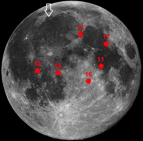
The white arrow shows the proposed Chang’e 3 landing site in comparison to the Apollo landing sites. Image Credit: NASA (amended by the author).
The previous Chang’e 1 and 2 lunar orbiting missions, launched in 2007 and 2010, represented the first phase of the Chang’e program. Chang’e 3, to be followed by Chang’e 4, represent the second phase of the program, both involving rovers. The third phase, with Chang’e 5, will be a sample-return mission and is currently scheduled for 2017. After that, it is anticipated that a new program will commence, which might culminate in a manned landing.
Chang’e is the name of a Chinese goddess who ascended to the Moon after consuming an immortality pill and there befriended a jade rabbit who was already a lunar resident. The elements of this legend were relayed by NASA to the Apollo 11 crew ahead of the first Moon landing in 1969. Michael Collins famously responded “Okay. We’ll keep a close eye out for the bunny girl.”
The Chang’e 3 lander will set down in Sinus Iridum, which is an extension of Mare Ibrium and roughly opposite the Apollo 15 landing site near Hadley Rille.
Chang'e-3
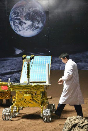
A scale model of the Chang’e 3 rover.
Image Credit: Unknown (sourced from http://www.ecns.cn)
After landing, a solar-powered rover will roll off the lander and commence its mission, which is expected to last for at least three months, although presumably that will include a lot of down-time while the two-week-long lunar nights prevail.
The Chang’e 3 lander itself will continue to operate as a stationary science platform. It will be powered by a radioisotope thermoelectric generator and hence will be largely unaffected by the presence or absence of direct sunlight. The lander will operate a number of science instruments, including an optical telescope and a “soil probe” to conduct analyses of lunar regolith.
The Chang’e 3 rover will have a mass of 120 kilograms, including a 20 kg science payload. It is reported that it will explore widely over an area within a 5 kilometer radius of the lander. This sounds a little ambitious considering that the Spirit and Opportunity rovers traveled just 2 to 3 kilometers over their first year of operation, but the Chang’e 3 rover will have more advanced technology and more solar energy to draw upon.
The rover will also have autonomous hazard avoidance and navigation capacity, but with a radio delay of only 1.3 seconds from Earth, it will be mostly under the direct control of an Earth-based driver.
The rover’s science payload will include an alpha particle X-ray spectrometer, which has been standard issue on all the NASA Mars rovers to date, to enable geochemical analyses. The rover will also have a radar device on its underside, to investigate the structure and depth of the lunar regolith as well as the underlying structure of the lunar crust.
AmericaSpace.
Guillermo Gonzalo Sánchez Achutegui
ayabaca@gmail.com
ayabaca@hotmail.com
ayabaca@yahoo.com

domingo, 24 de noviembre de 2013

ESA : Swarm constellation deploys booms

 
Swarm boom deployment

Swarm constellation deploys booms

23 November 2013
Following yesterday’s successful launch, another critical milestone has been passed. The three Swarm satellites have each deployed their four-metre long boom.
Carrying instruments essential to the mission, the boom trails at the back of the satellite.
The long booms were folded in the rocket fairing during launch.
During deployment, the booms swings gently back and forth before locking into position. Now deployed, each satellite measures just over nine metres in length.
 
Since magnetic cleanliness is of paramount importance to the mission, each satellite’s sensitive scalar magnetometer is housed at the end of the boom.
This is to avoid any magnetic disturbance that the electrical units on the satellite body could cause.
The optical bench holding the vector field magnetometer and the three startrackers are mounted half-way alon
Swarm instruments (side view)
g the boom.
The constellation was launched yesterday at 12:02 GMT (13:02 CET) on a single Rocket launcher from the Plesetsk Cosmodrome in northern Russia.
Swarm liftoff

All three satellites are controlled by ESA teams at the European Space Operation Centre in Darmstadt, Germany.
Engineers are working around the clock during the critical launch and early orbit phase to ensure the satellites are healthy and to switch on and configure vital systems. This phase lasts for about four days.
Related articles:
Swarm ready for launch22 November 2013
Swarm ready for launch22 November 2013 With the rocket fully fuelled and its electrical checks done, Swarm is set to liftoff today at 12:02 GMT from Plesetsk in northern Russia.
Swarm launch timeline21 November 2013
ESA
Guillermo Gonzalo Sánchez Achutegui